Maranhão, Brazil
Brazil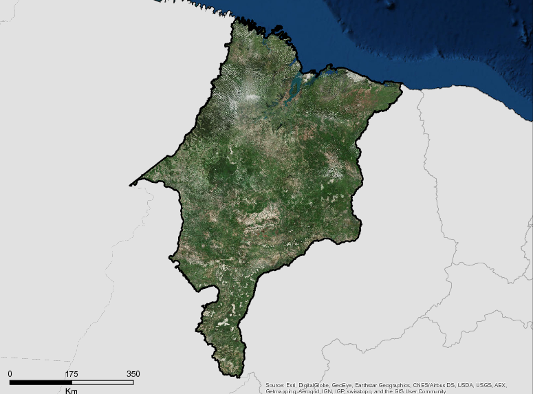
Description
The State of Maranhão has surface areas of the order of 331 thousand km², being the eighth largest state in Brazil and the second in the Northeast in territorial extension. The State has 217 municipalities and two Metropolitan Regions: Greater São Luis and Southwest Maranhense. The Maranhão portion of Amazonia Legal covers an area equivalent to 80% of the territorial area of the State, about 264,000 km². In this area are located 188 municipalities of Maranhão.
The State has five geographical meso-regions, subdivided into 21 geographic microregions, where 217 municipalities are located. The municipal boundaries were established based on IBGE Resolution No. 05 of October 10, 2002.
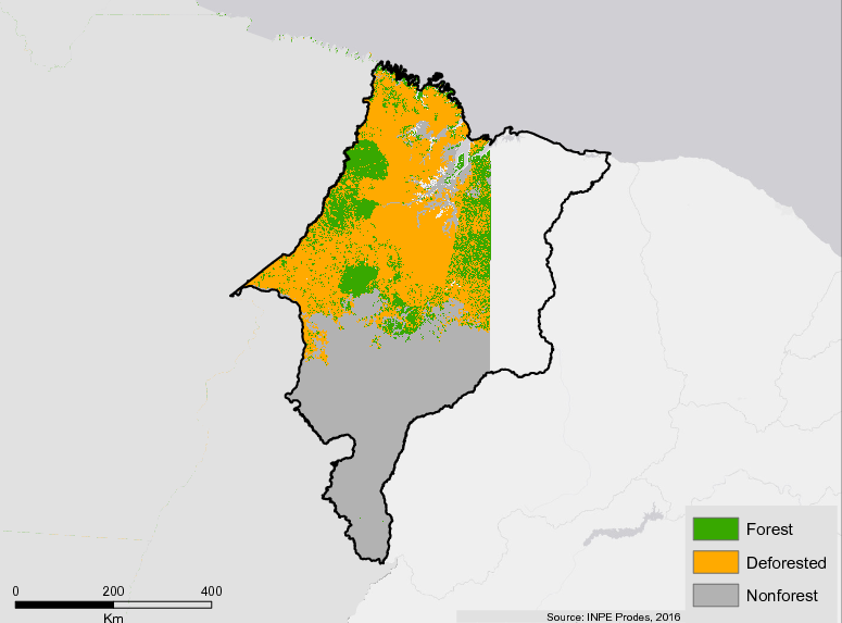
Deforestation is concentrated in an area called the ‘Deforestation Arc’ , passing through Tocantins, part of Pará and Mato Grosso, the entire state of Rondônia, the south of the Amazonas arriving at Acre. According to the Forest Code, the region delimited by the Legal Amazon rules on the use of rural property, as properties within the Legal Amazon are obliged to maintain 80% of the area as legal reserve in the Amazon Biome and 35% in the Cerrado biome. Those located properties outside the limits of the Legal Amazon need to conserve 20% of the property as reservation. The territory of Maranhão consists of the biomes Amazônia, Cerrado and Caatinga bomes, which gives it great biological and environmental diversity.
Additional information can be found on the GCF Impact Platform.
Summary
Demographics
Urban vs. Rural Population
| Category | % | |
|---|---|---|
| Urban | 63.00 | |
| Rural | 36.00 |
Ethnic Groups
| Group | % | |
|---|---|---|
| Multi-ethnic | 66.52 | |
| White | 22.13 | |
| Black | 9.69 | |
| Other | 1.13 | |
| Indigenous | 0.54 |
Economy
GDP Breakdown
| Category | % | |
|---|---|---|
| Services | 69.60 | |
| 19.00 | ||
| Agriculture, Forestry | 11.40 |
Forest Status
Major Vegetation Types
| Category | km² | |
|---|---|---|
| Other Land Uses | 141,510 | |
| Pastureland | 56,202 | |
| Forest | 33,946 | |
| Secondary Vegetation | 30,014 | |
| Agriculture | 530 |
Drivers of Deforestation
Large-scale livestock, Large-scale agriculture, Smallholder Agriculture
Deforestation Rates
Notes
| a. | Due to different methodological approaches and base years, Forest Status data fields may differ slightly. Data sources for each field are listed below. |
Sources
| 1. | IBGE link |
| 2. | IBGE link |
| 3. | Plano Estadual do Maranhão link |
| 4. | Instituto Maranhense de Estudos Socioeconômicos e Cartográficos link |
| 5. | IBGE link |
| 6. | Instituto Maranhense de Estudos Socioeconômicos e Cartográficos link |
| 7. | IBGE link |
| 8. | Prodes link |
| 9. | TerraClass 2014 |
Overview of Forest Monitoring and Measurement Systems
Forest monitoring systems are a fundamental component of Brazil’s REDD + efforts, since they provide key information for the planning of public policies. Maranhao uses systems based on remote sensing, using information collected by satellites. Brazil has systems that allows monitoring of forest cover over time, identifying where deforestation is occurring, analyzing the dynamics of land use, and others.
In addition, monitoring systems allow for the elaboration of historical series for REDD + activities and periodically generate data for results to be measured from the reference levels of forest emissions based on the historical series.
The main developer of monitoring systems in the country is the National Institute of Space Research (INPE), linked to the Ministry of Science, Technology, Innovation and Communications. INPE has the PRODES project, which carries out satellite monitoring of shallow-deforestation in the Legal Amazon and has been producing annual deforestation rates in the region since 1988, which are used by the Brazilian government to establish public policies. The annual rates are estimated from the deforestation increments identified in each satellite image that covers the Legal Amazon.
In this way, the state of Maranhão uses this system to monitor deforestation in the state’s forests and then make emission reduction estimates for deforestation.
Reference Levels and Targets
Deforestation Rates
Sources
| 1. | Based on Conservative Technical Committee of the Amazon Fund Emission Factors |
| 2. | Rio Branco Declaration based on national FREL 2010-2015 |
| 3. | Prodes link |
Laws, Policies & Strategies
Policies and Strategies
Plan for Prevention and Control of Deforestation (PPCD) – Maranhao’s PPCD was formalized in 2011 through Decree 27.317. For each planning and execution period, the Plan indicate areas of intervention priorities, centered on four thematic areas: Regularization and Land Planning, Monitoring and Control, Promoting Sustainable Activities, and Governance, Information Management and Transparency.
Laws and Regulations
Law 10.595, 24/5/2017 – Creates the “Maranhão Verde” Programme, aimed at promoting and developing projects to support conservation and environmental recovery.
Law 10.444, 05/05/2016 – Establishes the State Policy for Technical Assistance and Rural Extension for Agriculture Family and Agrarian Reform – PEATER / MA and the State Assistance Technical Program and Rural Extension for Family Agriculture and Agrarian Reform – PROATER / MA in the State of Maranhão
Law 10316, 17/09/2015 – Establishes the Ecological-Economic Macrozoneamento of the State of Maranhão and makes other provisions.
Law 10276, 07/07/2015– Institutes the Program for Environmental Adequacy of Property and Rural Activity and adopts other measures.
Law 9,412, 13/07/2011 – Regulates Environmental Compensation within the State of Maranhão.
Law 9,413, 13/07/2011 – establishes the System State of Nature Conservation Units of Maranhão and makes other provisions
Law 5.405, 1992 – establishes the Code of Protection of the Environment and State System of Environment and the appropriate use of resources in the State of Maranhão.
Institutional Framework
Secretary of Environment (SEMA) – Plans and coordinated the implementation of policies related to the promotion, organization, regulation, control and control of actions related to the exploration and preservation of the environment and natural resources.
SEMA has three Secretariats (Sustainable Development, Licensing, Environmental Resources) and nine Superintendents (Water Resources, Environmental Licenses, Biodiversity and Protected Areas, Forest Resources, Waste Management, Green Economy, Environmental Education, Surveillance, Planning and Monitoring)
Secretary of Agriculture, Livestock and Fisheries- SAGRIMA – promotes the sustainable development of agribusiness productive chains, through programmed actions aimed at increasing the production and productivity of grains, vegetable and animal protein and fiber, productive infrastructure, agricultural protection and defense, fishing and aquaculture, and establishing mechanisms to guide the decisions of economic agents, producers, traders, importers and others, in the alternative allocation of resources, and to develop and correct market failures.
Secretary of State for Family Agriculture (SAF) – SAF aims to promote the development of family agriculture, combat rural poverty, facilitate access to credit and technical assistance instruments, promote social inclusion in land management and reorganization processes, promote land regularization, provide technical assistance and rural extension, expand opportunities for professional training and generation of work and income, and improve the quality of life of farmers and their families and to stimulate sustainable rural development in the State of Maranhão.
Zoning & Spatial Planning
The Brazilian Federal Government, through the Ecological-Economic Zoning (ZEE), requires states to regulate areas for economic and conservation activities within their territory. In Maranhao, the ZEE is coordinated by the State Secretariat for Planning and Budget(Seplan) and is used as a planning tool to be institutionalized to guide the State’s Sustainable Strategic Planning. SEPLAN and Emprapa have coordinated to develop a ZEE Macro in 2014 on a 1: 1,000,000 scale. After the public consultation, the plan was approved by the state assembly state through Law No. 10,316 of September 17, 2015. The plan was validated by the federal government.
Maranhão completed the 1:1,000,000 (MACROZEE / MA) ZEEin 2014, a process that represents only one step to achieve the ZEE on a scale compatible with the desired 1: 250,000 scale. This instrument, submitted at the beginning of 2015 to the State Legislative Assembly, was institutionalized through Law 10,316 of September 17, 2015.
Subsequently, the MacroZEE was submitted to the Coordinating Committee of the EEZ – CCZEE – of the Ministry of Environment for recognition by the Federal Government on November 25, 2015, thus complying with the provisions of Forestry Code Law 12.651, dated May 25, 2012.
Looking ahead, the Government of Maranhão intends to elaborate the more detailed ZEE as an instrument to guide in the formulation of public policies related to socioeconomic and environmental development in order to guide efficient territorial planning. The refined ZEE will also serve as a tool to guide investment decisions by the private sector. For this purpose, the elaboration of the State’s Ecological-Economic Zoning (ZEE / MA) in the 1: 250,000 scale was included in the 2016-2019 Pluriannual Plan, with budgetary resources secured in 2016. By governmental decision, the elaboration of the Ecological-Economic Zoning of the State of Maranhão on this scale, will take place in stages, beginning with the area of the Amazon Biome of the State of Maranhão.
Engagement & Participation with Indigenous Peoples and Local Communities
The Alto Turiaçú, Awa, Carú and Araribóia indigenous lands combine with the gurupí Biological Reserve to form one of the most pristine sections of the Amazonian forest, in its primary state, in the State of Maranhão. Protection of these regions is a priority to maintain the standing forest and combat illegal practices. Initially, through Decree No. 31,794 of May 23, 2016, the Government of Maranhão established the State Committee for articulating public policies for the indigenous peoples of the State of Maranhão, with a view towards advancing various public policies, including the need for a guarantee protection. Subsequently, through DECREE No. 33,928, OF MARCH 22, 2018, the commission was restructured to follow the process of implementation of the public policies created in the previous decree.
Regarding production systems of local communities, the Government of Maranhão works together with indigenous peoples through various activities being carried out by the Family Agriculture System (SAF System). In 2017, 281 indigenous families received aid totaling R $600 thousand in projects for the development of family agriculture. In the State’s Family Agriculture Procurement Program (Procaf), a modality was created exclusively for indigenous peoples, with R $ 500 thousand reserved for the acquisition of food from indigenous production through the presentation of projects – both individuals and collective organizations indigenous peoples.
Partnerships and Ongoing Initiatives
Amazonia SAR
- Description
-
Amazonia SAR implements a deforestation detection system utilizing orbital imaging radar to monitor 950,000 km2 per year (23% of the Amazon biome). Of the total land monitored, 764,000 km2 is comprised of areas under the greatest pressure of deforestation, 144,000 km2 is in the state of Amapá, and an additional 5% of isolated points in the Amazon biome will be monitored due to specific demand.
- Partners
- Federal Government/Defense Ministry – Operations and Management Center of the Amazonian Protection System (CENSIPAM)
- Funding Amount
- $20,783,439.87
- Initiative Type
- Protected Areas Initiative
- Initiative Status
- Contracted
Babaçu Plantations LPS
- Description
-
Babaçu Plantations LPS enriches babassu palm tree plantations in the Amazon biome within the state of Maranhão by supporting conservation and sustainable management, as well as recovering damaged areas using agroforestry systems in three municipalities: Lago do Junco, Lago da Pedra and Bacabal in the Médio Mearim region. The initiative benefits settlement populations, quilombolas, traditional communities, and family farmers in the region.
- Partners
- Association of Settlement Areas in the state of Maranhão (ASSEMA)
- Funding Amount
- $2,363,754.25
- Initiative Type
- Sustainable Production Initiative
- Initiative Status
- Contracted
Banco do Brasil Foundation – Amazon Fund
- Description
-
The Amazon Fund provides support to projects related to developing sustainable production in conjunction with conservation in the Amazon Biome. Beneficiaries of The Amazon Fund’s supported projects include: traditional communities (indigenous peoples, quilombolas, rubber tappers, riverside populations, family farmers, subsistence agriculturists), rural workers involved in settlement projects, low-income populations at risk of social exclusion, collective undertakings, solidarity economies, non-profit institutions governed under private law, and public administration entities.
- Partners
- Fundação Banco do Brasil (FBB)
- Funding Amount
- $7,550,588.95
- Initiative Type
- Sustainable Production
- Initiative Status
- Contracted
Banco do Brasil Foundation – Amazon Fund / Phase 2
- Description
-
Phase II of The Amazon Fund supports projects that facilitate the development of productive activities promoting the conservation and sustainable use of the Amazon Biome; the initiative benefits traditional communities (indigenous peoples, quilombolas, rubber tappers, riverside populations, family farmers, subsistence agriculturists), rural workers involved in settlement projects, and low-income populations at risk of social exclusion.
- Partners
- Banco do Brasil Foundation (FBB)
- Funding Amount
- $4,979,666.36
- Initiative Type
- Protected Areas Initiative
- Initiative Status
- Contracted
Consolidating Territorial and Environmental Management in Indigenous Lands
- Description
-
Supports the implementation and development of the Territorial and Environmental Management Plan (PGTA) across five Indigenous Territories (TI) in the states of Amazonas, Maranhão, and Pará—covering 9,375,076 hectares of land and 19,531 TI inhabitants.
- Partners
- Indigenous Work Center (CTI)
- Funding Amount
- $3,688,281.11
- Initiative Type
- Financial Initiative
- Initiative Status
- Contracted
Empowering Environmental Monitoring and Control in Order to Combat Illegal Deforestation in the Brazilian Amazon
- Description
-
Empowers environmental monitoring and control in order to combat illegal deforestation in the Brazilian Amazon over a period of 15 months in regions under the greatest deforestation pressure; utilizes trucks and helicopters to enforce actions in the field.
- Partners
- Brazilian Institute of Environment and Natural Resources (Ibama)
- Funding Amount
- $17,662,033.20
- Initiative Type
- Protected Areas Initiative
- Initiative Status
- Contracted
Environmental Management Qualification Program
- Description
-
Supports the strengthening of environmental management in the 529 municipalities across nine states in the Legal Amazon through (i) offering training and technical support (ii) disseminating knowledge and information through networks (iii) fostering innovation and promoting liaison with other government levels and general society within the framework of environmental public policies.
- Partners
- Brazilian Institute of Municipal Administration (IBAM)
- Funding Amount
- $9,019,941.79
- Initiative Type
- Protected Areas Initiative
- Initiative Status
- Contracted
Environmental Monitoring of Brazilian Biomes
- Description
-
Environmental Monitoring of Brazilian Biomes achieves three objectives: (i) Development and enactment of deforestation monitoring systems for the Atlantic Forest, Caatinga, Pampa, and Pantanal biomes (ii) Calculation of CO2 emissions for deforested areas and creation of a proposed Forest Reference Emission Level (FREL) for each biome, to be provided to the United Nations Framework Convention on Climate Change (UNFCCC) (iii) Platform development for analysis and visualization of vast geospatial data to benefit the entire national territory through platform development.
- Partners
- Space Science, Applications and Technology Foundation (FUNCATE) and National Institute of Space Research (INPE)
- Funding Amount
- $15,911,139.52
- Initiative Type
- Protected Areas Initiative, Financial Initiative
- Initiative Status
- Contracted
Environmental Monitoring via Satellite in the Amazon Biome
- Description
-
Supports the development of studies on land use and land coverage in the Amazon biome; expands and improves environmental monitoring by satellites, as performed by the National Institute of Space Research (INPE).
- Partners
- National Institute of Space Research (INPE)/Science, Applications and Space Technology Foundation (FUNCATE)
- Funding Amount
- $27,783,399.45
- Initiative Type
- Protected Areas Initiative
- Initiative Status
- Contracted
Environmental Operations Company
- Description
-
Structures the Environmental Operations Company of the National Public Security Agency (FNSP) both physically and operationally to perform environmental operations in the Amazon Biome.
- Partners
- Federal Government/Ministry of Justice – National Public Security Force (FNSP)
- Funding Amount
- $11,796,765.00
- Initiative Type
- Protected Areas Initiative
- Initiative Status
- Contracted
Ethnic-environmental protection for isolated or recently contacted indigenous people in the Amazon
- Description
-
This protection initiative provides support and protection to isolated indigenous peoples and those recently contacted throughout the entire Amazon biome in order to establish physical limits and protect natural resources in settled areas within the territories of these groups and surrounding areas. The project aims to help reduce deforestation in the Amazon.
- Partners
- Center for Indigenous Work (CTI)
- Funding Amount
- $7,514,829.72
- Initiative Type
- Protected Areas Initiative
- Initiative Status
- Contracted
FIP CAR PROJECT
- Description
-
Brief description: Its objective is to contribute to the increase of environmental regularity among the rural properties of the Cerrado, increasing the conformity of the properties with the Federal Law. Greater regularity means less deforestation, less degraded areas, and more reclaimed areas.
The specific objectives of the Project are:
(1) to improve the capacity of the MMA and 9 state environmental agencies to receive, analyze and approve records of the Rural Environmental Registry and to connect the data to the Rural Environmental Cadastre System (SICAR);
(2) support, in the municipalities covered by the Project, real estate records in the CAR.
The project includes eleven environmental agencies from the following federal units: Goiás, Bahia, Maranhão, Minas Gerais, Mato Grosso do Sul, Mato Grosso, Paraná, Piauí, São Paulo, Tocantins and the Federal District.
- Partners
- Ministry of Environment, through the Brazilian Forest Service (SFB), Government of the State of Maranhão through SEMA
- Funding Amount
- US $ 49,980,000.00
- Initiative Type
- Refundable external financing Non-refundable national funding
- Initiative Status
- Early in Hiring
Forest Information to support public and private sectors in management initiatives
- Description
-
Breve descrição: The objective of the Technical Cooperation (TC) is to implement the National Forest Inventory (NFI) in Cerrado biome and consolidate the National Forest Information System (NFIS) as policy instruments, capable of producing timely and quality information for decision makers in the public and private sectors. The project will contribute to the promotion of sustainable programs aimed at mitigating greenhouse gas (GHG) emissions in the Cerrado. It also aims at promoting partnerships with States and other institutions in the region to promote information exchange and dissemination. The project is part of Brazil’s Investment Plan (IP) for the Forest Investment Program (FIP), which seeks to promote the sustainable use of land and the improvement of forest management in the Cerrado Biome, thus helping to reduce pressure on remaining forests, decreasing greenhouse gas (GHG) emissions and increasing carbon sequestration. It finances the generation and dissemination of forest information to support public and private sectors in management initiatives aimed at the conservation and enhancement of forest resources in the Cerrado biome.
- Partners
- Climate Investment Fund – Forest Investment Program with 26 partners
- Funding Amount
- USD 24,450,000
- Initiative Type
- Financiamento externo não reembolsável Assistência Técnica
- Initiative Status
- Executed from June 2014 – June 2018 (48 months)
GCF States
- Description
-
Brief description: In order to develop its Jurisdictional System for REDD + in the State of Maranhão, through the GCF, with the opportunity of the UNDP edict – window A, it sought a partnership with IPAM to carry out this project, which began in October 2018.
- Partners
- SEMA Maranhão and IPAM
- Funding Amount
- U $ 400 thousand
- Initiative Type
- Non-refundable external financing
- Initiative Status
- Running
GREEN MARANHÃO PROGRAM
- Description
-
Brief description: The Maranhão Verde Program, instituted by Law 10,595, dated May 24, 2017 and regulated by Decree No. 32,969, of June 5, 2017, is designed to promote and develop projects aimed at supporting conservation and environmental recovery, involving the participation of selected beneficiary families, who will receive the Maranhão Verde Grant.
Maranhão Verde seeks to generate environmental and social benefits, promoting citizenship, improving living conditions and raising the income of the population living in extreme poverty. The beneficiary families of this Program should develop activities for conservation and recovery of natural resources in previously defined areas, which may be: conservation units, territories occupied by riparian, extractive and traditional communities, as well as other areas defined as priority by act of Power Executive. The Program also aims to promote the environmental, social, educational, technical and professional training of the beneficiary population.
Initially it will be implanted in the Mirador State Park Area and each Family will receive R $ 300.00 bimonthly.
- Partners
- Leader: SECRETARY OF STATE OF THE ENVIRONMENT AND NATURAL RESOURCES-SEMA-MA, Partners: OSCIPS
- Funding Amount
- R $ 4.300.000
- Initiative Type
- State’s budget
- Initiative Status
- Running
More sustainability in the field
- Description
-
Supports the implementation of the Rural Environmental Registry (CAR) in the state of Maranhão to benefit the owners and settlers of rural family properties with up to four fiscal modules that develop agrosilvopastoral activities (including settlements, agrarian reform projects, and traditional communities making collective use of their territory).
- Partners
- State of Maranhão
- Funding Amount
- $12,191,589.46
- Initiative Type
- Land Titling and Registration
- Initiative Status
- Contracted
Multisectoral Commitment of the Soy Moratorium
- Description
-
In the areas in the Amazonian biome of the State of Maranhão, grain producers are included in the multisectoral commitment of the Soy Moratorium. This commitment results from the fulfillment of requirements that guarantee a production free of deforestation, whether legal or illegal. The commitment is managed by a group (Soybean Working Group) composed of civil society actors, traders, federal government and financial institutions. The moratorium applies to the entire Amazon biome.
- Partners
- Food & Beverage Outlets
- Initiative Type
- Sustainable Supply Chain
- Initiative Status
- Implementation
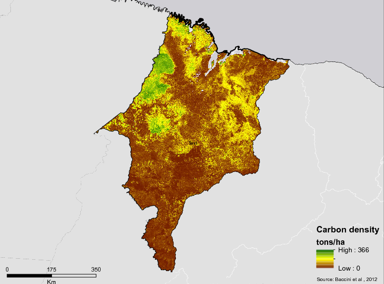
National Forest Inventory – The Amazon
- Description
-
Implements the Forest Inventory in the Amazon Biome to produce information on forest resources, carbon stocks, and territory use by regional populations.
- Partners
- Federal Government/Brazilian Forest Service (SFB)
- Funding Amount
- $31,999,485.00
- Initiative Type
- Protected Areas Initiative
- Initiative Status
- Contracted
Partnerships with the indigenous of the State
- Description
-
It should also be noted that the IPAM has been maintaining partnerships in the last two years with the indigenous people of the State, in particular with those occupying the Araribóia Indigenous Land (Guajajara People). More specifically, IPAM maintains climate change training activities in collaboration with COCALITI (Coordination of Caciques and Leaders of the Araribóia Indigenous Land) with COAPIMA (Coordination of Organizations and Joints of the Indigenous Peoples of Maranhão). In 2016 and 2017, IPAM promoted specific workshops on climate change and territorial and environmental monitoring with indigenous peoples. At the time, the application “Alerta Clima Indígena” was presented to the indigenous people. The application aims to send information about fire and deforestation to the Indigenous Lands and also to support the territorial monitoring, thus helping in the management of the territory and consequently in the maintenance of the forest areas.
- Partners
- IPAM, OCALITI (Coordination of Caciques and Leaders of the Araribóia Indigenous Land) with COAPIMA (Coordination of Organizations and Joints of the Indigenous Peoples of Maranhão
- Initiative Type
- Indigenous Peoples
Plan for Prevention and Control of Deforestation (PPCD-AP)
- Description
-
The Tactical-Operational Action Plan brings together actions for the containment of deforestation in the Legal Amazon and the feasibility of alternatives for protection and sustainable use of the forest. The State of Amazonas is in its third phase of the Plan (2018 to 2020).
After the launching of its 1st Phase (2008), the reduction in annual rates of deforestation was notable, with values close to 500 km² remaining for seven years, but from 2015 onwards it increased again, reaching 2016 to 1,129 km², increasing 176% compared to 2009. The 2nd Phase of the Plan (2012 to 2015) was not affirmed as a development strategy for the state, remaining with a sectorial character and parallel to the main economic policies. The State stayed for two years without updating its plan, resuming in 2017 the elaboration of its 3rd Phase, recognizing its strategic importance with efforts to contribute to the national goal of reducing deforestation, corroborating the scope of the reduction in 80% until the year 2020.
The Plan is divided into three axes ((i) monitoring, control and surveillance; (ii) territorial and territorial planning; and (iii) agroforestry production chains and sustainable practices), which comprise six macro actions. During the year 2018, mainly actions foreseen in the Plan related to the Axis 2 (Command and Environmental Control) were executed, referring to macro licensing and environmental fiscalization actions. As a result of the actions already carried out, there is the Amazonas Legal Program, which had its first edition in the municipality of Apuí, where the Rural Environmental Licensing and Licensing Unit (CAR) occurred with a historical result of more than 687 rural producers served, 472 applications for Environmental Operating License (LO), 120 records in the CAR.
Besides Amazonas Legal, there were also two enforcement actions in the south of the state. As a result it is possible to observe a reduction 14% 1 in the estimated deforestation rate for the year 2018 in relation to the high rate presented in the year 2016. The result of these actions will be most seen in 2019, as the annual rate of deforestation consolidated by Prodes has differentiated intervals, which always cover August to July of the following year.
- Partners
- Government of the State, ICMBIO, IBAMA, ALEMA, FUNAI, EMBRAPA, Municipal Governments, Federation of Farmers, Federation of Agriculture
- Funding Amount
- $100,000
- Initiative Type
- Planning Initiative
- Initiative Status
- Under Implementation
PPP-ECOS in the Amazon – Phase 2
- Description
-
Supports the structuring of sustainable productive chains through public calls within the Small Eco-social Projects Program (PPP-ECOS) to benefit populations of rural, traditional, and indigenous peoples, along with quilombolas, riverside populations, fishermen, and extractive communities in the states of Mato Grosso, Tocantins, and Maranhão within the limits of the Brazilian Amazon.
- Partners
- Society, Population and Nature Institute (ISPN)
- Funding Amount
- $5,460,127.11
- Initiative Type
- Sustainable Production Initiative
- Initiative Status
- Under implementation
Preserving the Babassu Forest
- Description
-
Supports the operation of the Babassu Fund to select and support socioenvironmental projects related to agro-extractive organizations in the states of Maranhão, Tocantins, and Pará; supports skill development, provides technical support, and strengthens associativism through public calls of projects approved by BNDES to benefit traditional communities of babassu coconut breakers.
- Partners
- Interstate Association of the Movement of Women Babassu Coconut Breakers – AMIQCB
- Funding Amount
- $2,777,933.43
- Initiative Type
- Sustainable Production Initiative
- Initiative Status
- Contracted
Prevfogo / IBAMA
- Description
-
The initiative supports the structure of the National Center to Prevent and Combat Forest Fires (PREVFOGO) programme both physically and operationally, along with training locals to monitor, prevent, and combat forest fires and unauthorized burns in the Amazon Biome through environmental education.
- Partners
- Brazilian Institute of the Environment and Renewable Natural Resources (IBAMA)
- Funding Amount
- $6,252,557.57
- Initiative Type
- Protected Areas Initiative
- Initiative Status
- Contracted
Profisc I-B
- Description
-
Profisc I-B is organized by the Federal Government to support the activities of Ibama for environmental monitoring and deforestation control in the Legal Amazon.
- Partners
- Brazilian Institute of Environment and Natural Resources (Ibama)
- Funding Amount
- $41,822,410.40
- Initiative Type
- Protected Areas Initiative, Financial Initiative
- Initiative Status
- Contracted
Project to Support National Strategies for Reducing Deforestation and Forest Fires in the Brazilian Cerrado.
- Description
-
Brief description: Implemented throughout the Cerrado Biome, especially Municipalities and Priority Conservation Units for the prevention and control of deforestation and forest fires with the objective of implementing integrated fire management and rural environmental registration in selected areas of the biome Thick. In the case of the State of Maranhão, it covered 23 Municipalities with 8,100 assisted families, of which 2,500 were Peoples and Traditional Communities (PCT’s) and 5,600 families of family farmers.
- Partners
- Trust Fund: Mitigation of Climate Change in the Brazilian Cerrado, No. 071814 Administrator: International Bank for Reconstruction and Development (Bird), of the World Bank Group Donor: Department of Environment, Food and Rural Affairs (Defra)
- Funding Amount
- US $ 15.3 million (for the whole of Brazil)
- Initiative Type
- Refundable or non-refundable mixed funding
- Initiative Status
- completed
Review of the Plan for the Prevention and Control of Deforestation and Burns PPCDQ – 2017-2020
- Description
-
The plan represents the guidelines that will guide the strategies, goals and actions of the State in the quadrennium 2017-2020 and its main objective is to reduce deforestation and the degradation of native vegetation, as well as to control forest fires, promoting the maintenance of ecosystem services.
- Partners
- Leader : BNDES / Amazon Fund, Partners: Government of Acre
- Funding Amount
- R $ 328,317.00
- Initiative Type
- Non-refundable National Financing
- Initiative Status
- Running
Small Eco-Social Projects in the Amazon
- Description
-
Small Eco-Social Projects in the Amazon supports four public calls-for-submission for selecting and funding low-cost socioenvironmental projects focusing on family farmers and traditional communities living in the Amazon Biome across the states of Maranhão, Mato Grosso , and Tocantins.
- Partners
- Society, Population and Nature Institute (ISPN)
- Funding Amount
- $6,456,480.19
- Initiative Type
- Financial Initiative
- Initiative Status
- Contracted