Rondônia, Brazil
Brazil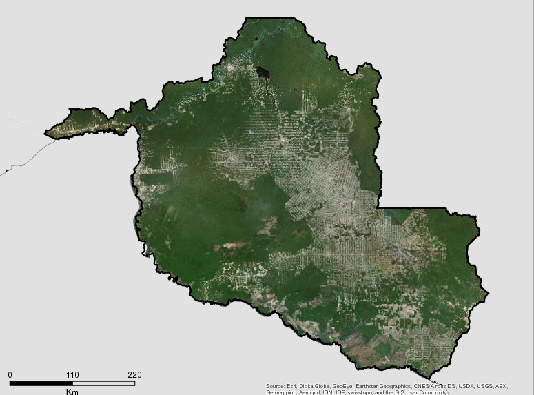
Description
The Government of Rondônia is increasingly committed to prevention and control of deforestation, understanding that the current agricultural land-use allocations of the State has already reached the limits established in the Socio-Economic and Ecologic Zoning. Rondonia seeks to develop urgent measures to promote actions that reduce pressure on protected areas, including indigenous lands and conservation units, and begin the process of restoring the altered areas of Legal Reserves and Permanent Protection of rural properties.
Rondônia was occupied as a result of the integration policy military government, which intensified in the 1970s and 1980s, implementation of the Integrated Colonization Projects (ICP) and the Directed Settlement Projects (PAD), under the responsibility of the National Agrarian Reform – INCRA. This policy had two objectives: first enable the “modernization of agriculture” in the center-south of the country, mainly for the expansion of soybeans in Paraná, and for beef cattle Minas Gerais and Espírito Santo, expelling thousands of sharecroppers, squatters, lessees, rural workers and small producers who migrated to the agricultural frontier in the Amazon, with Rondônia being an option to life. The second objective was to reduce tensions in the field and maintain social movement of rural workers under state control, hiding misery in the Amazon or in the favelas that widened in the outskirts of big cities. In almost forty years of occupation the population of Rondônia increased from 130,000 inhabitants in 1970 to almost 1,500,000 inhabitants currently.
Additional information can be found on the GCF Impact Platform.
Summary
Demographics
Urban vs. Rural Population
| Category | % | |
|---|---|---|
| Urban | 73.50 | |
| Rural | 26.50 |
Ethnic Groups
| Group | % | |
|---|---|---|
| Multi-ethnic | 58.00 | |
| White | 34.00 | |
| Black | 7.00 | |
| Indigenous | 1.00 |
Economy
GDP Breakdown
| Category | % | |
|---|---|---|
| Services | 64.10 | |
| Agriculture, Forestry | 23.50 | |
| 18.30 |
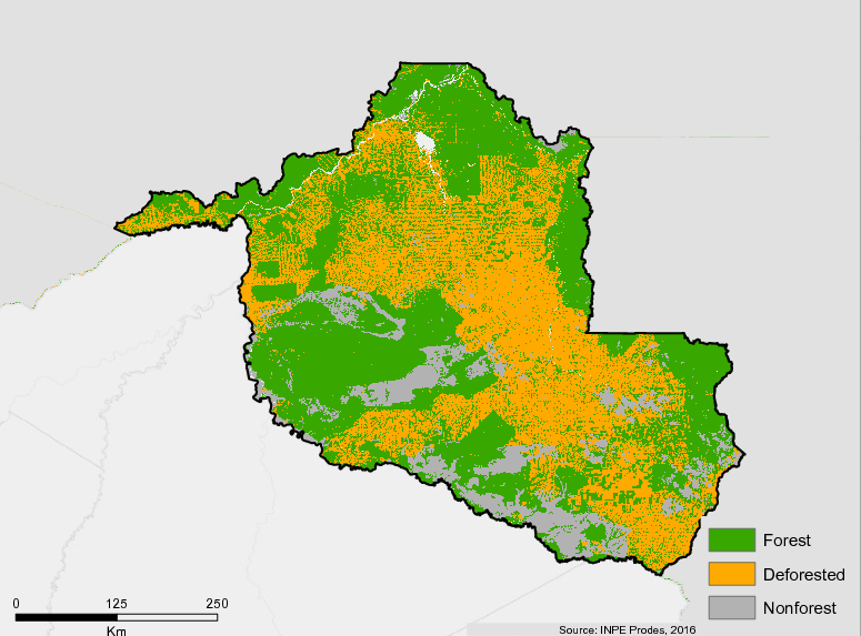
Forest Status
Major Vegetation Types
| Category | km² | |
|---|---|---|
| Forest | 123,029 | |
| Pastureland | 62,242 | |
| Other Land Uses | 41,642 | |
| Agriculture | 36,066 | |
| Secondary Vegetation | 15,472 |
Forest Management
| Category | km² | |
|---|---|---|
| Protected | 46,915 | |
| Unprotected | 117 |
Drivers of Deforestation
Activities related to extensive livestock and agriculture. Infrastructure works and colonization processes undertaken by the Brazilian Government since the 1970s.
Deforestation Rates
Notes
| a. | Due to different methodological approaches and base years, Forest Status data fields may differ slightly. Data sources for each field are listed below. |
Sources
| 1. | IBGE link |
| 2. | IBGE link |
| 3. | IBGE link |
| 4. | |
| 5. | |
| 6. | IBGE link |
| 7. | SEPLAN link |
| 8. | IBGE link |
| 9. | SEPLAN link |
| 10. | Prodes link |
| 11. | TerraClass 2014 |
Overview of Forest Monitoring and Measurement Systems
The forest monitoring systems developed by the federal government are a fundamental component of the country’s REDD + efforts, since they provide key information for the planning of public policies. The systems are based on remote sensing, using information collected by satellites. Brazil has systems that allow monitoring of forest cover over time, identifying where deforestation is occurring and analyzing the dynamics of land use change.
Having a robust national forest monitoring system that allows monitoring and reporting on REDD + activities is one of the requirements countries must meet to implement REDD +. It is worth mentioning that countries can adopt subnational systems as an interim measure, as Brazil has done with its biomes approach.
The monitoring systems allow the country to elaborate its historical series for REDD + activities and periodically generate data for results to be measured from the reference levels of forest emissions based on the historical series
The main developer of monitoring systems of the federal government is the National Institute of Space Research (INPE), linked to the Ministry of Science, Technology, Innovation and Communications. INPE still maintains partnerships for the development of systems with the Brazilian Ministry of Environment (MMA), the Brazilian Institute for the Environment and Renewable Natural Resources (IBAMA), the Brazilian Agricultural Research Corporation (EMBRAPA), linked to the Ministry of Agriculture , Livestock and Supply (MAPA), and Public universities.
The primary monitoring systems in operation are:
- PRODES– The PRODES project conducts satellite monitoring deforestation in the Legal Amazon and produces annual deforestation rates in the region, which provide information of great relevance for the formulation of Brazilian public policies. PRODES uses satellite images of the Landsat class (20 to 30 meters of spatial resolution), which allow mapping deforestation polygons larger than 6.25 hectares. PRODES data, which has a historical series beginning in 1988, were used in the elaboration of Brazilian submissions on REDD + for the Amazon biome.
- DETER– This system provides near real-time detection of changes in forest cover in the Legal Amazon. The changes in forest cover that DETER maps are forest clear cutting, forest degradation which leads to deforestation and forest fire scars. DETER maps may also include areas with logging activities. The information produced is fundamental to the effectiveness of the integrated control actions that combat deforestation in the region, guiding its planning. Its historical series began in 2004.
- DEGRAD– system, developed by INPE, to track forest degradation in the Legal Amazon. The system, which produced data for the period between 2007 and 2013, had the objective of mapping areas in the process of deforestation where the forest cover had not yet been totally removed. In the coming years, monitoring of degradation in the Legal Amazon will focus on fire degradation, based on the information produced by the Burning and Fire Monitoring Program.
- Fire and Fire Monitoring Program– The program monitors the occurrence of fires, with the purpose of providing daily information about fire sources to environmental protection institutions – through reports, graphs and statistics of fire outbreaks. With the information already available, INPE is developing a methodology to automate the calculation of burned area estimates.
- TerraClass– a survey that analyzes the areas identified as deforested to identify how such areas are occupied after removal of native vegetation. The project has already produced 5 surveys on the Legal Amazon (2004, 2008, 2010, 2012 and 2014) and a survey on the Cerrado biome (2013). TerraClass produces valuable information for the analysis and formulation of policies related to land use in the regions where it operates.
The year 2015 marks the beginning of a new phase for environmental monitoring in Brazil, with the creation of the Environmental Monitoring Program for the Brazilian Biomes . The Program aims to articulate and give greater coherence to ongoing monitoring efforts in the country, as well as to expand the monitoring of plant cover for all Brazilian biomes by 2018.
Reference Levels and Targets
Deforestation Rates
Sources
| 1. | Rio Branco Declaration based on national FREL 2010-2015 |
| 2. | Prodes link |
Laws, Policies & Strategies
Strategies and Policies
Plan of Prevention, Control, and Sustainable Alternatives to deforestation in Rondonia (PPCD) – Rondonia’s PPCD was passed in 2010 and was built around four thematic areas: (i) Territorial Planning and Land Regularization, (ii)Promotion for Sustainable Production, (iii) Command and Control Actions for the prevention of Deforestation and (iv) Training for the Decentralization of Environmental management.
Laws and Regulations
Complementary Law no 827, 07/15/2015 – Clarifies institutional roles and responsibilities, including those of the the Secretary of State for Environment and Development (SEDAM)
State Decree 17940, 2013 – Provides for the institution and implementation of the Environmental Regularization Program of the State of Rondônia – PRA / RO of properties and rural properties and provides other measures.
Decree State Law 1,144, 01/12/2012 – Provides for the State System of Nature Conservation Units of Rondônia – SEUC / RO and provides other measures
Decree 12.449, 2006- Introduces article in Decree n ° 7.903 of July 1, 1997, which regulated Law n ° 547 of December 30, 1993.
Decree 12.448, 2006 -Institutes the Register of Explorers and Consumers of Forest Products of the State of Rondônia – CEPROF-RO, the System of Marketing and Transport of Forest Products of the State of Rondônia SISFLORA-RO, its operational documents, and other measures.
Decree 12.447, 2006– Institutes the Forest Management of the State of Rondônia, and provides other measures
Decree 7903, 1997 -Regulates Law No. 547 of December 30, 1993, which provides for protection, recovery, control, inspection and improvement of the quality of the environment in the State of Rondônia.
State Law 547, 1993 -Provides for the creation of the State System of Environmental Development of Rondônia-SEDAR and its instruments, establishes measures to protect and improve the quality of the environment, defines the State Environmental Development Police, creates the Special Fund for Environmental Development-FEDARO and the Fund Special Reforestation Forest-FEREF.
Institutional Framework
The Secretary of State for Environmental Development (SEDAM) – was established on March 19, 1991 by Complementary Law No. 42 and reformed by Complementary Law No. 827 of July 15, 2015, with the primary function of formulating and implementing policies aimed at development environmental, rural and urban, monitoring and regulating activities related to the quality of life, the environment and natural resources, as well as promoting the management of the conservation units of the State of Rondônia.
SEDAM is also responsible for planning and carrying out activities related to the policy of rural environmental regularization, development, promotion, protection and environmental education, in partnership with IBAMA, the Environmental Police Battalion and the Secretariat of State for Public Security – SESDEC , which may cause harm to the environment, both for present and future generations.
SEDAM Cooridnator of Conservation Units (CUC) – responsible for coordinating the preparation and execution of studies, plans, programs, contracts, agreements and projects of Conservation Units – UCs and to promote the interactions between the units’ management. It is also responsible for proposing actions for the application of resources arising from environmental compensation in PAs; Establish procedures for the processing, application and management of resources derived from environmental compensation processes, destined to the Units; Establish operational and logistical mechanisms to maintain the integrity of PAs.
SEDAM Coordinator of Environmental Licensing (COLMAM) – Participate in the formulation of policies and guidelines for environmental sustainability, formulating plans, programs and projects for environmental licensing and monitoring, coordinating and supervising the development of polluting and potentially polluting activities, territorial planning activities and environmental monitoring.
SEDAM Coordinator of Environmental Protection (COPAM) – It is the responsibility of the Environmental Protection Coordination (COPAM) to participate in the formulation of policies and guidelines for environmental development, systematically evaluating complaints received about entrepreneurial activities harmful to the environment
SEDAM Coordinating Office of Rural Environmental Monitoring and Regulation (COMRAR) – Responsibility to coordinate and prepare plans, programs and projects concerning the monitoring and regularization of rural properties or possessions. Promoting the environmental regularization of rural properties and possessions in the State of Rondônia, strengthening their activities for those who fit the profile of small rural producers and jointly possess up to 04 (four) fiscal modules.
The Secretariat of State for Agriculture, Livestock and Land Settlement (SEAGRI) – responsible for participating in the formulation and implementation of policies and guidelines for the development of agriculture, fishing, forestry, agroindustrial and regularization and territorial planning of the State. Coordinates and monitors the implementation of projects to support agricultural, fishery, forestry, agroindustrial development and regularization and territorial planning of the State.
Zoning & Spatial Planning
Rondonia first passed it ecological and economic zoning (ZEE) in 1991 through Supplementary Law No. 52 of December 20, 1991. Since 1996 the ZEE in Rondoni has been guided by a State Commission for Socioeconomic and Ecological Zoning through decree nº 7.409, of March 28 1996.
In 2017 Rondonia is in the process of updating its Socio-Economic and Ecological Zoning plan which seeks to promote a balance between ecological, economic and social potentials and limitations for controlling current and future human activities by suggesting preventive and corrective measures that can be implemented and that ensure environmental quality. Revising its zoning plan will make Rondonia the first state in Brazil to create a revision legislation within the framework that governs zoning in the country (Decree 4,297 / 2002), according to the new Forest Code (Law 12.651 / 2012).
Engagement & Participation with Indigenous Peoples and Local Communities
Rondônia is home to the the Suruí Forest Carbon Project, which is the first REDD + indigenous project in the world to achieve international certifications and to sell carbon credits generated in its territory. The indigenous communities in Rondônia have an indigenous representative within SEDAM (Secretariat of State Environmental Development) that supports the articulation and promotion of specific public policies for Indigenous Peoples of the State.
Despite ongoing efforts, there is still a long way to go to ensure better governance and protection of indigenous populations and territories in Rondônia.
Partnerships and Ongoing Initiatives
Amazon Backyards
- Description
-
Amazon Backyards supports family farmers and Agrarian Reform settlements in the state of Rondônia within the municipalities of Machadinho D’Oeste, Cujubim and Itapuã do Oeste. The initiative assists family farmers and Agrarian Reform settlements in: (i) enrolling their rural properties in the Rural Environmental Registration, and (ii) implementing and conducting research on agroforestry systems (AFS) aimed at recovering altered or damaged legal forest reserves and permanent forest preservation areas
- Partners
- Center for Studies on Culture and the Environment in the Amazon (Rioterra)
- Funding Amount
- $4,032,464.95
- Initiative Type
- Protected Areas Initiative
- Initiative Status
- Contracted
Amazonia SAR
- Description
-
Amazonia SAR implements a deforestation detection system utilizing orbital imaging radar to monitor 950,000 km2 per year (23% of the Amazon biome). Of the total land monitored, 764,000 km2 is comprised of areas under the greatest pressure of deforestation, 144,000 km2 is in the state of Amapá, and an additional 5% of isolated points in the Amazon biome will be monitored due to specific demand.
- Partners
- Federal Government/Defense Ministry – Operations and Management Center of the Amazonian Protection System (CENSIPAM)
- Funding Amount
- $20,783,439.87
- Initiative Type
- Protected Areas Initiative
- Initiative Status
- Contracted
ARPA
- Description
-
Support the creation, implementation and management of conservation units in the Brazilian Amazon.
- Partners
- WWF, KFW and etc.
- Funding Amount
- R$ 5,000,000
- Initiative Type
- Non-refundable external financing
- Initiative Status
- Running
Banco do Brasil Foundation – Amazon Fund
- Description
-
The Amazon Fund provides support to projects related to developing sustainable production in conjunction with conservation in the Amazon Biome. Beneficiaries of The Amazon Fund’s supported projects include: traditional communities (indigenous peoples, quilombolas, rubber tappers, riverside populations, family farmers, subsistence agriculturists), rural workers involved in settlement projects, low-income populations at risk of social exclusion, collective undertakings, solidarity economies, non-profit institutions governed under private law, and public administration entities.
- Partners
- Fundação Banco do Brasil (FBB)
- Funding Amount
- $7,550,588.95
- Initiative Type
- Sustainable Production
- Initiative Status
- Contracted
Banco do Brasil Foundation – Amazon Fund / Phase 2
- Description
-
Phase II of The Amazon Fund supports projects that facilitate the development of productive activities promoting the conservation and sustainable use of the Amazon Biome; the initiative benefits traditional communities (indigenous peoples, quilombolas, rubber tappers, riverside populations, family farmers, subsistence agriculturists), rural workers involved in settlement projects, and low-income populations at risk of social exclusion.
- Partners
- Banco do Brasil Foundation (FBB)
- Funding Amount
- $4,979,666.36
- Initiative Type
- Protected Areas Initiative
- Initiative Status
- Contracted
Boletins de Desmatamento para o Corredor Tupi Monde
- Description
-
Análises periódicas das mudanças no uso da terra e desmatamento nas 7 Terras Indígenas que compõem o corredor Tupi Monde.
- Partners
- Idesam, Kanindé, Ecam e Associação Metareilá
Climate Governance Project Rondônia
- Description
-
Brief Description:
In Rondônia, $ 365,000 will be invested, through the Climate Governance project for Rondônia , which has the following objectives:
-
(i) Support the regulation and implementation of public policies and structuring instruments to reduce deforestation and promote the protection and sustainable use of forests;
-
(ii) Encourage private sector engagement, with a view to attracting investments for the implementation of sustainable production models and reduction of deforestation in the state;
-
(iii) To mobilize and strengthen the capacities of organized civil society to work on issues related to the reduction of deforestation and greenhouse gas emissions, including the reactivation of the State Forum on Climate Change.
-
- Partners
- Norad, UNDP, GCF, BVRio, IDESAM, Kanindé
- Funding Source
- Norad
- Funding Amount
- US $ 365,000
- Initiative Type
- Non-refundable external financing
- Initiative Status
- Running
Dissemination and Improvement of Sustainable Forest Management Techniques
- Description
-
Provides support to promote and expand sustainable forest management through training key players and workers, raising awareness, and applied research in the timber and forest sector of the states of Pará, Amazonas, and Rondônia. The initiative benefits not only workers in the timber and forest sector, but also operators of heavy machinery, forest communities, small rural producers, government agents, engineers, auditors, administrators, researchers, and forest students in both high school and higher education within the three states.
- Partners
- Tropical Forest Institute (IFT)
- Funding Amount
- $4,164,244.19
- Initiative Type
- Financial Initiative
- Initiative Status
- Concluded
Empowering Environmental Monitoring and Control in Order to Combat Illegal Deforestation in the Brazilian Amazon
- Description
-
Empowers environmental monitoring and control in order to combat illegal deforestation in the Brazilian Amazon over a period of 15 months in regions under the greatest deforestation pressure; utilizes trucks and helicopters to enforce actions in the field.
- Partners
- Brazilian Institute of Environment and Natural Resources (Ibama)
- Funding Amount
- $17,662,033.20
- Initiative Type
- Protected Areas Initiative
- Initiative Status
- Contracted
Environmental Management Qualification Program
- Description
-
Supports the strengthening of environmental management in the 529 municipalities across nine states in the Legal Amazon through (i) offering training and technical support (ii) disseminating knowledge and information through networks (iii) fostering innovation and promoting liaison with other government levels and general society within the framework of environmental public policies.
- Partners
- Brazilian Institute of Municipal Administration (IBAM)
- Funding Amount
- $9,019,941.79
- Initiative Type
- Protected Areas Initiative
- Initiative Status
- Contracted
Environmental Monitoring of Brazilian Biomes
- Description
-
Environmental Monitoring of Brazilian Biomes achieves three objectives: (i) Development and enactment of deforestation monitoring systems for the Atlantic Forest, Caatinga, Pampa, and Pantanal biomes (ii) Calculation of CO2 emissions for deforested areas and creation of a proposed Forest Reference Emission Level (FREL) for each biome, to be provided to the United Nations Framework Convention on Climate Change (UNFCCC) (iii) Platform development for analysis and visualization of vast geospatial data to benefit the entire national territory through platform development.
- Partners
- Space Science, Applications and Technology Foundation (FUNCATE) and National Institute of Space Research (INPE)
- Funding Amount
- $15,911,139.52
- Initiative Type
- Protected Areas Initiative, Financial Initiative
- Initiative Status
- Contracted
Environmental Monitoring via Satellite in the Amazon Biome
- Description
-
Supports the development of studies on land use and land coverage in the Amazon biome; expands and improves environmental monitoring by satellites, as performed by the National Institute of Space Research (INPE).
- Partners
- National Institute of Space Research (INPE)/Science, Applications and Space Technology Foundation (FUNCATE)
- Funding Amount
- $27,783,399.45
- Initiative Type
- Protected Areas Initiative
- Initiative Status
- Contracted
Environmental Operations Company
- Description
-
Structures the Environmental Operations Company of the National Public Security Agency (FNSP) both physically and operationally to perform environmental operations in the Amazon Biome.
- Partners
- Federal Government/Ministry of Justice – National Public Security Force (FNSP)
- Funding Amount
- $11,796,765.00
- Initiative Type
- Protected Areas Initiative
- Initiative Status
- Contracted
Ethnic-environmental protection for isolated or recently contacted indigenous people in the Amazon
- Description
-
This protection initiative provides support and protection to isolated indigenous peoples and those recently contacted throughout the entire Amazon biome in order to establish physical limits and protect natural resources in settled areas within the territories of these groups and surrounding areas. The project aims to help reduce deforestation in the Amazon.
- Partners
- Center for Indigenous Work (CTI)
- Funding Amount
- $7,514,829.72
- Initiative Type
- Protected Areas Initiative
- Initiative Status
- Contracted
GCF-Brasil: Governor’s Climate and Forest Task Force
- Description
-
Investimento internacional voltado a promover as agendas de clima e florestas nos Estados da Amazônia.
- Partners
- Idesam
Greener Rondônia
- Description
-
Greener Rondônia supports efforts towards monitoring, preventing, and combating deforestation resulting from forest fires and unauthorized burns in the state of Rondônia by training the Military Firefighters Aerial and Land Operations Base to be built by the State in the capital Porto Velho and purchasing materials and equipment to prepare the military along with four operational stations located in other municipalities throughout the state.
- Partners
- Firefighters in the state of Rondônia (CBMRO)
- Funding Amount
- $7,430,709.95
- Initiative Type
- Forest Monitoring and Enforcement
- Initiative Status
- Contracted
Materialize
- Description
-
Materialize builds a sustainable economic alternative to deforestation by strengthening the cupuassu and açaí berry production sector through the implementation of agroforestry systems. The initiative also increases and modernizes the production capacity of pulp processing units in traditional communities in the Ponta de Abunã river basin (municipalities of Porto Velho in the state of Rondônia and Acrelândia in the state of Acre) to benefit over 800 families associated with conglomerate entities and fruit processing plants.
- Partners
- Association of Small Agro-farmers in the RECA Project
- Funding Amount
- $2,411,118.40
- Initiative Type
- Sustainable Production Initiative
- Initiative Status
- Contracted
National Forest Inventory – The Amazon
- Description
-
Implements the Forest Inventory in the Amazon Biome to produce information on forest resources, carbon stocks, and territory use by regional populations.
- Partners
- Federal Government/Brazilian Forest Service (SFB)
- Funding Amount
- $31,999,485.00
- Initiative Type
- Protected Areas Initiative
- Initiative Status
- Contracted
Pact for the Forest
- Description
-
Pact for the Forest supports (i) the consolidation of the production chain of Brazil nuts, and (ii) the strengthening of productive activities related to açaí, cassava flour, and natural rubber in two indigenous lands and three extractive reserves in the state of Rondônia.
- Partners
- Elaboration and Development of Socioenvironmental Projects (Pacto das Águas)
- Funding Amount
- $2,348,558.47
- Initiative Type
- Sustainable Production Initiative
- Initiative Status
- Under implementation
PPCD
- Description
-
Brief Description:
The state government launched the Plan for Prevention, Control and Sustainable Alternatives to Deforestation – PPCD-RO in 2009, supported by the Ministry of the Environment – MMA, in an attempt to create guidelines for the control of deforestation in the state, structured under four thematic axes :
-
(i) land use planning and land titling;
-
(ii) Promotion of sustainable production;
-
(iii) Command and control actions for the prevention of deforestation; and
-
(iv) Development of activities for the decentralization of environmental management.
-
- Partners
- INPE / MMA
- Funding Amount
- 13 million.
- Initiative Type
- State’s budget
- Initiative Status
- In execution (we are monitored by INPE and SEDAM monitors the deforestation in the state CUs.
Prevfogo / IBAMA
- Description
-
The initiative supports the structure of the National Center to Prevent and Combat Forest Fires (PREVFOGO) programme both physically and operationally, along with training locals to monitor, prevent, and combat forest fires and unauthorized burns in the Amazon Biome through environmental education.
- Partners
- Brazilian Institute of the Environment and Renewable Natural Resources (IBAMA)
- Funding Amount
- $6,252,557.57
- Initiative Type
- Protected Areas Initiative
- Initiative Status
- Contracted
Profisc I-B
- Description
-
Profisc I-B is organized by the Federal Government to support the activities of Ibama for environmental monitoring and deforestation control in the Legal Amazon.
- Partners
- Brazilian Institute of Environment and Natural Resources (Ibama)
- Funding Amount
- $41,822,410.40
- Initiative Type
- Protected Areas Initiative, Financial Initiative
- Initiative Status
- Contracted
Project for Integrated Environmental Socioeconomic Development
- Description
-
Supports environmental management to prevent deforestation and forest degradation in the state of Rondônia through efforts to protect state conservation units, consolidate the Rural Environmental Registration (CAR), and strengthen municipal environmental management.
- Partners
- State of Rondônia/State Secretariat for Environmental Development
- Funding Amount
- $13,995,972.57
- Initiative Type
- Land Titling and Registration
- Initiative Status
- Contracted
Sowing Rondônia
- Description
-
Sowing Rondônia supports the environmental adequacy of rural properties in the state of Rondônia through (i) the elaboration and implementation of Projects for the Recovery of Degraded and/or Changed Areas in properties of up to four fiscal modules, (ii) rural extension, training, and institutional strengthening of family farmers’ associations, and (iii) landscape monitoring and evaluation within the municipalities of Ariquemes, Castanheiras, Cujubim, Itapuã do Oeste, Jaru, Ji-Paraná, Machadinho D`Oeste, Novo Horizonte, Ouro Preto, Presidente Médici, Rio Crespo and Rolim de Moura. Beneficiaries of the project include family farmers and their respective associations, managers and technicians of the state environmental agency, technical assistance and rural extensions, and other members of local society.
- Partners
- Center for Studies on Culture and the Environment in the Amazon – Rioterra
- Funding Amount
- $7,626,224.16
- Initiative Type
- Sustainable Livelihoods
- Initiative Status
- Contracted
Strengthening environmental management in the Amazon
- Description
-
(i) supports efforts to strengthen environmental management related to developing policies aimed at preventing and controlling deforestation within priority municipalities in the Amazon biome, (ii) supports studies to advance land-title diagnosis in the states of Amazonas, Mato Gross, Pará, and Rondônia in order to expand disclosure on the progress of ongoing efforts towards widespread land-title regularization in the state of Pará, and (iii) supports improvements to PA management in the Calha Norte region in the state of Pará. The initiative benefits population and civil servants residing in the municipalities on the Brazilian Ministry of the Environment’s list of priority cities to mitigate deforestation, as well as peoples living in protected areas of the Calha Norte region in the state of Pará.
- Partners
- Institute of People and the Environment of the Amazon (IMAZON)
- Funding Amount
- $3,194,485.79
- Initiative Type
- Protected Areas Initiative, Financial Initiative
- Initiative Status
- Contracted
Sustainable Indigenous Amazon Project
- Description
-
The project benefits indigenous communities in the TIs Igarapé Lourdes, Zoró, Rio Guaporé and Rio Negro Ocaia by helping to design and implement Territorial and Environmental Management Plans (PGTA).
- Partners
- Association in Defense of Ethno-environmental Kanindé
- Funding Amount
- $2,156,669.07
- Initiative Type
- Financial Initiative
- Initiative Status
- Contracted
Sustainable landscapes.
- Description
-
Support for the implementation of the CAR, Program for the Recovery of degraded areas-PRADA for conservation units, all of them in the RESEX of the municipality of Machadinho do D ‘Oeste. Of the 14 million Reais, 5 million have already been disbursed.
- Partners
- Leader: World Bank, Partners: GEF / FUNBIO / CI / MMA.
- Funding Amount
- R$ 14,000,000
- Initiative Type
- Non-refundable external financing
- Initiative Status
- Running.
Use of Social Technologies to Reduce Deforestation
- Description
-
Contributes to environmentally sustainable food security and income generation in riverine and agricultural households in communities influenced by hydroelectric projects in the states of Pará, Mato Grosso, Rondônia, and Tocantins by implementing family units of diverse agroecological food production to reduce pressure on natural resources.
- Partners
- Interstate Agricultural Development Association – ADAI
- Funding Amount
- $2,779,138.85
- Initiative Type
- Sustainable Production Initiative
- Initiative Status
- Contracted