Roraima, Brazil
Brazil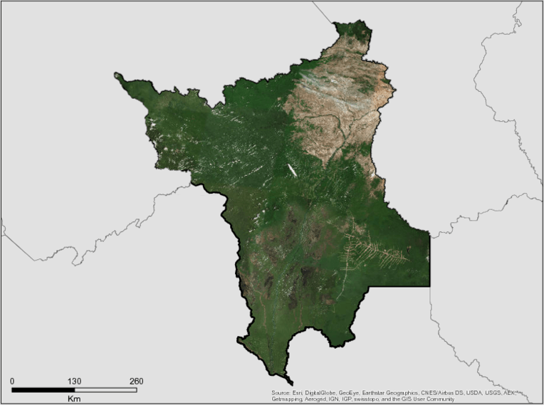
Description
Roraima is one of the two Brazilian states that was born from the Federal Constitution of 1988. The state is located north of the Brazilian Amazônia and covers roughly 225,000 km². It borders the Cooperative Republic of Guyana (formerly British Guiana) and the Bolivarian Republic of Venezuela, with the states of Amazonas and Pará. The whole state occupies around 2.6% of the Brazilian territory and 4.5% of the Brazilian territory. Legal Amazon.
The state of Roraima presents basically a vegetative composition in which the humid forests predominate, represented by the phytoecological units: Dense Ombrophylous Forest, Open Ombrophylous Forest, Seasonal Forest and Alluvial Ombrophylous Forest, and in the central and north-northeast , the savannah areas in their most diverse features.
The forests are predominantly of the rainy or ombrophilous type in the southern and seasonal part in the central and northern part of the state. They have a spectrum ranging from terra firme forests to those of periodically flooded floodplains. The alluvial forests are restricted to the floodplains of the main watercourses, as well as to some flooded areas of the southwest region, these interspersed with features of campinarana and pioneer formations.
The features of savannas, which dominate the central and north-northeast part of the state, are in tree, park and grassy forms. In the extreme north of Roraima one observes the feature characterized like esthetic, in the arboreal forms and park. At present, there is a high degree of anthropism in the environments dominated by the savannas, represented mainly by the occupation with pastures and crops, as well as altered abandoned areas.
In addition to the phytoecological units represented by the various forms of Campinarana and Pioneer Formations, areas of ecological tension or transition (contacts) can be evidenced in the State of Roraima between the two forest features, between savannas and forests, between campinarana and forests and between pioneer formations and forests.
Biodiversity, scenic waters and exotic beauties, richly scattered in varied and readily accessible environments, are important for social development. Its ethnic-cultural constitution is unique, in that more than 50% of the State is made up of indigenous lands and the whole lives in the same space, although enclosing diverse cultural elements.
Its exploitation can only be made via the environment, society and economy equation.
The Roraima Forest still represents the vulnerable point of the development of the young state. Illegal logging and the predominance of archaic production methods, such as the use of fire, are still vivid and priority issues for current environmental management.
Summary
Demographics
Urban vs. Rural Population
| Category | % | |
|---|---|---|
| Urban | 84.20 | |
| Rural | 15.80 |
Ethnic Groups
| Group | % | |
|---|---|---|
| Multi-ethnic | 68.80 | |
| White | 20.00 | |
| Black | 7.40 | |
| Indigenous | 3.80 |
Economy
GDP Breakdown
| Category | % | |
|---|---|---|
| Services | 87.50 | |
| 8.70 | ||
| Agriculture, Forestry | 3.80 |
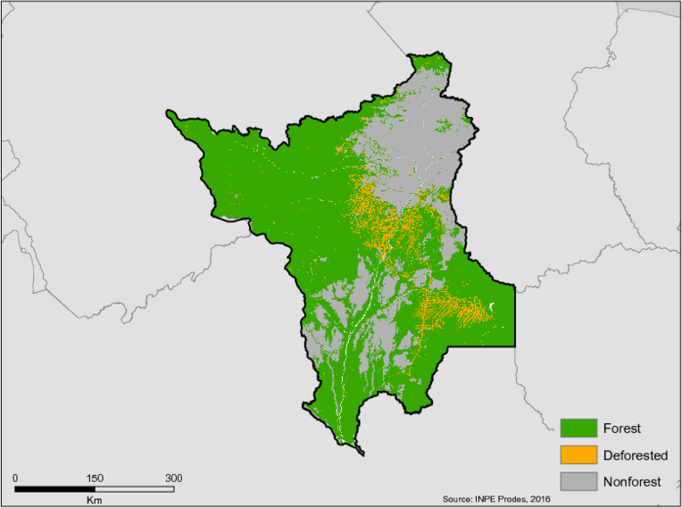
Forest Status
Major Vegetation Types
| Category | km² | |
|---|---|---|
| Forest | 151,690 | |
| Other Land Uses | 63,947 | |
| Pastureland | 4,890 | |
| Secondary Vegetation | 3,672 | |
| Agriculture | 15 |
Forest Management
| Category | km² | |
|---|---|---|
| Unprotected | 120,505 | |
| Protected | 31,185 |
Drivers of Deforestation
The deforestation in Roraima is driven primarily by agriculture and livestock expansion. Burning to clear areas often results in out of control forest fires which reaches large tracts of vegetation, causing forest degradation and at times acting as a pre-cursor to deforestation.
Logging is also a relevant factor that contributes to deforestation. Although most logging is licensed, there is still illegal logging in more remote areas, including in indigenous territories.
Deforestation Rates
Notes
| a. | Due to different methodological approaches and base years, Forest Status data fields may differ slightly. Data sources for each field are listed below. |
Sources
| 1. | https://cidades.ibge.gov.br/brasil/rr/panorama |
| 2. | IBGE |
| 3. | https://cidades.ibge.gov.br/brasil/rr/panorama |
| 4. | TerraClass 2014 |
| 5. | https://uc.socioambiental.org/uc/pesquisa/uf/RR |
Overview of Forest Monitoring and Measurement Systems
Roraima has an environmental monitoring and prevention division that monitors the licensed areas. The state is in the process of adapting a monitoring system offered free of charge by the state of Pará. Roraima must purchase the satellite images to activate full functionality of the system. FEMARH uses PRODES data to monitor forest cover.
The state is also conducting the rural environmental registry (CAR) and elaborating the PRA.
Reference Levels and Targets
Deforestation Rates
Sources
| 1. | Rio Branco Declaration based on national FREL 2010-2015 |
Laws, Policies & Strategies
Strategies and Policies:
Licensing Program: Provides a streamlined processes for environmental licensing including modules for granting water use, inspection and monitoring. The firs module for family agriculture was implemented in January 2018 with the expectation that by the end of the year all the modules will be in operation. FEMAR will assign the same program to the municipalities that wish to implement it.
Program Legal Title – Program for land regularization of the land to the State. A task force has been established to streamline processes.
Laws and Regulations:
Law no 976, 2014 – This Law provides for the policy of rural land regularization of occupation on lands in the state of Roraima, through right of use measures that allow the rational and economic use of rural public lands, assuring to all those who work there and producing the opportunity of access to property, in order to comply with the principles of social justice, agricultural development and social and environmental sustainability.
Law no 815, 2011 –The State Foundation of the Environment, Science and Technology of the State of Roraima – FEMACT-RR, created by State Law No. 001, art. 46, item III, item 2, of January 26, 1991, and regulated by the Delegated Law No. 004, of January 16, 2003, is transformed into a State Foundation for the Environment and Water Resources of Roraima – FEMARH-RR, Secretary of State for Planning and Development – SEPLAN. The Institute of Forest Development of the State of Roraima – IDEFER-RR, created by State Law No. 709, of March 30, 2009, is transformed into an Institute of Support for Science, Technology and Innovation of the State of Roraima – IACTI- RR, linked to SEPLAN. The activities of science, technology and research carried out by FEMACT-RR are now absorbed by IACTI-RR.
Complementary Law no 143, 2009 – This Complementary Law establishes the System of Planning and Territorial Planning of the State of Roraima as an instrument of State Policy for Sustainable Development, in the form established by the State Constitution. The Land Planning and Planning System of the State of Roraima, hereinafter referred to as SPOT / RR, is the main guiding instrument for planning land occupation and controlling the use of natural resources in the territory of the State of Roraima, to be followed in the implementation of plans, programs, projects, works and public and private activities.
Complementary Law no 144, 2009– establishes the System of Planning and Territorial Planning of the State of Roraima and provides other measures.
Law no 693, 2008 – Creates the Center for Geotechnology, Cartography and Territorial Planning – CGPTERR, as a Decentralized Administrative Unit of the Secretariat of State for Planning and Development – SEPLAN, and makes other provisions.
Law no 7, 1994 – Establishes the Code of Protection for the Environment for the Administration of Environmental Quality, Protection, Control and Development of the Environment and appropriate use of the Natural Resources of the State of Roraima.
Law no 30, 1992 – Creates the Institute of Lands and Colonization of Roraima and gives other measures.
Institutional Framework
The State Foundation for the Environment and Water Resources (FEMARH/RR) – created by State Law No. 815 of July 7, 2011, FEMARH aims to promote, elaborate, manage, coordinate and implement the policy of the environment and water resources of the State of Roraima, with the purpose of ensuring control, preservation, conservation and environmental recovery, aiming at sustainable socioeconomic development and improvement of the quality of life of the population.
Institute of Support to Science, Technology and Innovation (IACTI / RR) – IACTI / RR was also instituted by State Law nº 815 of July 7, 2011, to manage, coordinate and execute the policy of science, technology, innovation and forest management of the State of Roraima, with the purpose of stimulating, promoting and fostering scientific and technological development, with the realization and utilization of scientific research and Amazonian studies and their the sustainable socioeconomic development of the State and the improvement of the quality of life of the population.
Center for Geotechnology, Cartography and Territorial Planning (CGPTERR) – CGPTERR is a decentralized administrative unit that is part of the organizational structure of the State Secretariat for Development Planning – SEPLAN, created by State Law nº 693 of 31 December 2008, aims to coordinate and carry out the systematic mapping of the territory of the State of Roraima, supporting the planning and territorial planning activities of the State, and especially the planning, coordination, monitoring and evaluation of the execution of the work of the State. ecological-economic zoning, as well as territorial management in Roraima, among other duties provided for in the Law.
Institute of Land and Colonization of the State of Roraima (ITERAIMA) – ITERAIMA was created by State Law No. 030 of December 26, 1992, with the purpose to execute the land policy of the State, vested with powers to regularize public and vacant lands of the State or those transferred from the Union, by virtue of the law, or incorporated by any legal means to the State Patrimony, as well as the regulation of urban and rural areas, state ownership and possession .
Zoning & Spatial Planning
The Economic Ecological Zoning (ZEE-RR) began in 1992, but was not approved at the time. With the resumption in 2009, new studies were carried out by the CPRM , although the ZEE was not approved due to administrative issues.
New efforts began in 2013 although these efforts stalled as the Ministry of Environment did not accept a series of studies which had inconsistencies in information. These studies were ordered to be re-done.
Efforts resumed in 2016, in the current administration and ten diagnoses of technical areas have been completed with four more in progress. A final two diagnoses are still pending, which, once complete, will represent a completion of the ZEE-RR, to be submitted for consideration and approval to the Legislative Assembly and National Commission of the ZEE in the Ministry of Environment.
Engagement & Participation with Indigenous Peoples and Local Communities
Roraima has about 47% of its territory made up of Indian lands and a specific secretariat for dealing with indigenous affairs, the State Secretariat of Indians. This secretariat provides resources and servers to plan and implement actions to assist 450 indigenous communities in the areas of health, education, agricultural production, psychological and cultural assistance.
Partnerships and Ongoing Initiatives
Agreement of Technical Cooperation Between Censipam and Femarh
- Description
-
The purpose of ACT is to promote training, capacity building, production and sharing, through geoservices, geospatial, hydrological and meteorological images, data and information, as well as technical cooperation related to structuring, modeling, production and dissemination of geospatial information produced or managed by stakeholders in the geographical area of the Legal Amazon.
- Partners
- FEMARH and CENSIPAM
- Initiative Type
- State’s budget
- Initiative Status
- Agreement signed
Amazonia SAR
- Description
-
Amazonia SAR implements a deforestation detection system utilizing orbital imaging radar to monitor 950,000 km2 per year (23% of the Amazon biome). Of the total land monitored, 764,000 km2 is comprised of areas under the greatest pressure of deforestation, 144,000 km2 is in the state of Amapá, and an additional 5% of isolated points in the Amazon biome will be monitored due to specific demand.
- Partners
- Federal Government/Defense Ministry – Operations and Management Center of the Amazonian Protection System (CENSIPAM)
- Funding Amount
- $20,783,439.87
- Initiative Type
- Protected Areas Initiative
- Initiative Status
- Contracted
Banco do Brasil Foundation – Amazon Fund
- Description
-
The Amazon Fund provides support to projects related to developing sustainable production in conjunction with conservation in the Amazon Biome. Beneficiaries of The Amazon Fund’s supported projects include: traditional communities (indigenous peoples, quilombolas, rubber tappers, riverside populations, family farmers, subsistence agriculturists), rural workers involved in settlement projects, low-income populations at risk of social exclusion, collective undertakings, solidarity economies, non-profit institutions governed under private law, and public administration entities.
- Partners
- Fundação Banco do Brasil (FBB)
- Funding Amount
- $7,550,588.95
- Initiative Type
- Sustainable Production
- Initiative Status
- Contracted
Banco do Brasil Foundation – Amazon Fund / Phase 2
- Description
-
Phase II of The Amazon Fund supports projects that facilitate the development of productive activities promoting the conservation and sustainable use of the Amazon Biome; the initiative benefits traditional communities (indigenous peoples, quilombolas, rubber tappers, riverside populations, family farmers, subsistence agriculturists), rural workers involved in settlement projects, and low-income populations at risk of social exclusion.
- Partners
- Banco do Brasil Foundation (FBB)
- Funding Amount
- $4,979,666.36
- Initiative Type
- Protected Areas Initiative
- Initiative Status
- Contracted
CAR Roraima
- Description
-
CAR Roraima supports the implementation of the Rural Environmental Registration (CAR) in the state of Paraná to benefit all 15 municipalities in the state, including smallholders and family rural squatters that develop agroforestry activities through training, infrastructure improvements, adaptation of the state’s legal framework and development of the state’s plan for the recovery of permanent preservation areas (APPs) and legal reserves.
- Partners
- State of Roraima (Fundação Estadual do Meio Ambiente e Recursos Hídricos de Roraima – FEMARH)
- Funding Amount
- $4,536,254.28
- Initiative Type
- Protected Areas Initiative
- Initiative Status
- Contracted
Empowering Environmental Monitoring and Control in Order to Combat Illegal Deforestation in the Brazilian Amazon
- Description
-
Empowers environmental monitoring and control in order to combat illegal deforestation in the Brazilian Amazon over a period of 15 months in regions under the greatest deforestation pressure; utilizes trucks and helicopters to enforce actions in the field.
- Partners
- Brazilian Institute of Environment and Natural Resources (Ibama)
- Funding Amount
- $17,662,033.20
- Initiative Type
- Protected Areas Initiative
- Initiative Status
- Contracted
Environmental Management Qualification Program
- Description
-
Supports the strengthening of environmental management in the 529 municipalities across nine states in the Legal Amazon through (i) offering training and technical support (ii) disseminating knowledge and information through networks (iii) fostering innovation and promoting liaison with other government levels and general society within the framework of environmental public policies.
- Partners
- Brazilian Institute of Municipal Administration (IBAM)
- Funding Amount
- $9,019,941.79
- Initiative Type
- Protected Areas Initiative
- Initiative Status
- Contracted
Environmental Monitoring of Brazilian Biomes
- Description
-
Environmental Monitoring of Brazilian Biomes achieves three objectives: (i) Development and enactment of deforestation monitoring systems for the Atlantic Forest, Caatinga, Pampa, and Pantanal biomes (ii) Calculation of CO2 emissions for deforested areas and creation of a proposed Forest Reference Emission Level (FREL) for each biome, to be provided to the United Nations Framework Convention on Climate Change (UNFCCC) (iii) Platform development for analysis and visualization of vast geospatial data to benefit the entire national territory through platform development.
- Partners
- Space Science, Applications and Technology Foundation (FUNCATE) and National Institute of Space Research (INPE)
- Funding Amount
- $15,911,139.52
- Initiative Type
- Protected Areas Initiative, Financial Initiative
- Initiative Status
- Contracted
Environmental Monitoring via Satellite in the Amazon Biome
- Description
-
Supports the development of studies on land use and land coverage in the Amazon biome; expands and improves environmental monitoring by satellites, as performed by the National Institute of Space Research (INPE).
- Partners
- National Institute of Space Research (INPE)/Science, Applications and Space Technology Foundation (FUNCATE)
- Funding Amount
- $27,783,399.45
- Initiative Type
- Protected Areas Initiative
- Initiative Status
- Contracted
Environmental Operations Company
- Description
-
Structures the Environmental Operations Company of the National Public Security Agency (FNSP) both physically and operationally to perform environmental operations in the Amazon Biome.
- Partners
- Federal Government/Ministry of Justice – National Public Security Force (FNSP)
- Funding Amount
- $11,796,765.00
- Initiative Type
- Protected Areas Initiative
- Initiative Status
- Contracted
Ethnic-environmental protection for isolated or recently contacted indigenous people in the Amazon
- Description
-
This protection initiative provides support and protection to isolated indigenous peoples and those recently contacted throughout the entire Amazon biome in order to establish physical limits and protect natural resources in settled areas within the territories of these groups and surrounding areas. The project aims to help reduce deforestation in the Amazon.
- Partners
- Center for Indigenous Work (CTI)
- Funding Amount
- $7,514,829.72
- Initiative Type
- Protected Areas Initiative
- Initiative Status
- Contracted
GCF/IPAM
- Description
-
The State of Roraima, through the GCF, selected IPAM as a partner to develop a project to create a Jurisdictional System for REDD and environmental services, having as an opportunity the announcement of UNDP – window A. The project will be presented until April 30, 2018.
- Partners
- IPAM, GCF, UNDP
- Funding Source
- Norway
- Initiative Type
- Jurisdictional Planning
- Initiative Status
- Proposal Submitted
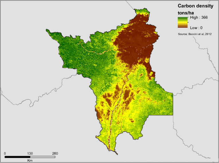
National Forest Inventory – The Amazon
- Description
-
Implements the Forest Inventory in the Amazon Biome to produce information on forest resources, carbon stocks, and territory use by regional populations.
- Partners
- Federal Government/Brazilian Forest Service (SFB)
- Funding Amount
- $31,999,485.00
- Initiative Type
- Protected Areas Initiative
- Initiative Status
- Contracted
Prevfogo / IBAMA
- Description
-
The initiative supports the structure of the National Center to Prevent and Combat Forest Fires (PREVFOGO) programme both physically and operationally, along with training locals to monitor, prevent, and combat forest fires and unauthorized burns in the Amazon Biome through environmental education.
- Partners
- Brazilian Institute of the Environment and Renewable Natural Resources (IBAMA)
- Funding Amount
- $6,252,557.57
- Initiative Type
- Protected Areas Initiative
- Initiative Status
- Contracted
Profisc I-B
- Description
-
Profisc I-B is organized by the Federal Government to support the activities of Ibama for environmental monitoring and deforestation control in the Legal Amazon.
- Partners
- Brazilian Institute of Environment and Natural Resources (Ibama)
- Funding Amount
- $41,822,410.40
- Initiative Type
- Protected Areas Initiative, Financial Initiative
- Initiative Status
- Contracted
State Committee for the Prevention and Combat of Forest Fires
- Description
-
The Committee works throughout the year with preventive actions and, when necessary, gathers resources from several institutions to carry out the fight against forest fires.
- Partners
- FEMARH, Corpo de Bombeiros, EMBRAPA, SEAPA, IBAMA, BRIGADAS MUNICIPAIS etc.
- Initiative Type
- Forest Fire Prevention
- Initiative Status
- Meeting periodically