Pastaza, Ecuador
Ecuador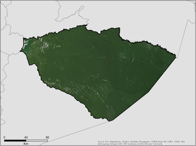
Description
The Province of Pastaza is located in the center of the Ecuadorian Amazon Region, between the geographic coordinates 1° 10 south latitude and 78° 10 west longitude; 2° 35 south latitude and 76° 40 west longitude. It limits to the north, with the province of Napo and Orellana, to the south with the province of Morona Santiago, to the east the Republic of Peru, and to the West the Province of Tungurahua.
The political division of the province is of 1 four cantons, Pastaza, Mera, Santa Clara and Arajuno and these in turn have a total of 17 rural parishes, of which five, Sarayacu, Montalvo, Rio Tigre, Rio Corrientes and Curaray are the parishes within the province that occupy 85% of the provincial territory, do not have road connectivity and have the greatest diversity in Ecuador.
The population of the Province of Pastaza is 83,933 inhabitants (INEC 2010) with a projection to 2014 of 94,511 inhabitants. The urban parish of Puyo is the most populated with 36,659 inhabitants, followed by Shell with 8,752 inhabitants and in third place Simón Bolívar with 5,682 inhabitants, among which have seven different ethnic groups such as the Quechuas, Zaparos, Iwias, Andoas, Waoranis, Shuar and Achuar. to more of the mestizo and black groups. The nationality with greater representation is the Amazonian Quechua and the one with the smallest population is the zapara that has a Unesco recognition for its almost extinct language. in the Province of Pastaza it is registered in terms of permanent crops, sugarcane is the one with the highest planted production, which is 6,354, with no data on harvest, production and sale; followed by cocoa with 1,590 cultivated hectares of which 60.88% of the crop was harvested, with a production of 104 tons of which 66 were sold, corresponding to 56.90%; In the third place, the banana crop is planted with 116 hectares sown with 100% of the harvested crop, producing 4,969 tons of which 47.55% was sold.
The extension of the province of Pastaza is of 29.642.77 km2, beginning its territory in the Amazonian mountain range of the Andes until the Amazonian plain its altitudinal range oscillates between the 3.196 msnm located in the extreme west of the province at 152 msnm located in the eastern end of the province. Territorially, Pastaza maintains an Intervened area that obeys the area where the most important cities of the province are located, and the Sosotenible ecological development area, which frames the area of national parks, Yasuni in its 44.51% and Llanganates in its 14%, as also the Ecological Area of Sustainable Provincial Development of Pastaza with an extension of 92% of the province, around 23,714.22 km2.
Summary
Demographics
Urban vs. Rural Population
| Category | % | |
|---|---|---|
| Rural | 56.00 | |
| Urban | 44.00 |
Ethnic Groups
| Group | % | |
|---|---|---|
| Kichwas | 21.23 | |
| Shuar | 6.37 | |
| Achuar | 3.06 | |
| Andoas | 2.93 | |
| Huaoranis | 1.41 | |
| Shiwiar | 0.97 | |
| Zapara | 0.54 |
Economy
GDP Breakdown
| Category | % | |
|---|---|---|
| Exploitation of mines and quarries | 68.50 | |
| Others | 8.30 | |
| Public administration | 7.50 | |
| Building | 3.90 | |
| Teaching | 3.80 | |
| Transportation, information and communications | 3.20 | |
| Accommodation and meals activities | 2.50 | |
| Commerce | 2.30 |
Forest Status
Major Vegetation Types
| Category | km² | |
|---|---|---|
| Forest | 26,695 | |
| Wetlands | 1,310 | |
| Agriculture | 999 | |
| Shrubby Vegetation | 478 | |
| Other | 152 | |
| Urban Zones | 7 |
Forest Management
| Category | km² | |
|---|---|---|
| Protected areas | 25,000 | |
| Other | 4,642 |
Drivers of Deforestation
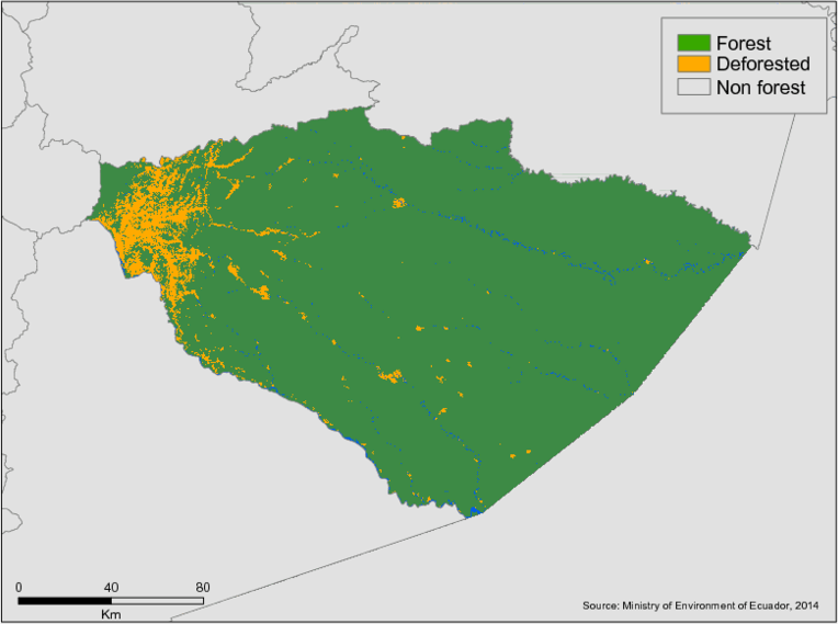
In the province there is a significant environmental impact in the intervened area, since most of the population of the province is concentrated, this means that the human activities carried out in this area are mainly affecting water resources. The main rivers where the highest population concentration is located are Rio Pindo Grande, Rio Motolo, Rio Salome, Rio Pindo Chico, Rio Puyo, Estero Citayacu, and Estero La Talanga. Degradation occurs primarily in the western portion of the province.
Principal drivers of deforestation include:
Mining.
The largest mining in the province of Pastaza is related to the extraction of stone material that is extracted mainly from the banks of the Pastaza, Bobonaza, Anzu, Arajuno rivers, among others, for this reason there are mines in the four cantons of the province, the material of these mines are used for road maintenance, expansion of the provincial road network; and other constructive activities. The extraction of the stone material begins with the removal of the same in the river beds, which is transported by dump trucks to storage centers for subsequent shipment to the different construction sites.
Petroleum.
The oil industry is the most representative economic activity for Ecuador and in the last three decades, oil income has been the first source of national income. Pastaza is one of the provinces from where oil is extracted, there are 22 oil blocks that are in the province.
Deforestation Rates
Notes
| a. | Due to different methodological approaches and base years, Forest Status data fields may differ slightly. Data sources for each field are listed below. |
Sources
| 1. | CONALI 2014 |
| 2. | |
| 3. | http://www.pastaza.gob.ec/pdf/consejo_planificacion/COMPONENTE%20SOCIO%20CULTURAL.pdf |
| 4. | http://app.sni.gob.ec/sni-link/sni/Portal%20SNI%202014/FICHAS%20F/16_PASTAZA.pdf |
| 5. | http://www.pastaza.gob.ec/pdf/consejo_planificacion/COMPONENTE%20ECONOMICO.pdf |
| 6. | PNUD 2010 |
| 7. | http://www.pastaza.gob.ec/pdf/consejo_planificacion/COMPONENTE%20BIOFISICO.pdf |
Overview of Forest Monitoring and Measurement Systems
Ecuador is one of the first countries to complete the National Forest Monitoring System process and have its Technical Annex successfully analysed by the UNFCCC, enabling the country to receive results-based payments for REDD+. The UN-REDD Programme continues to provide technical assistance to the Government for the result-based payments phase, and is collaborating in the development of Ecuador’s national determined contribution (NDC). In 2017, the Programme provided support to define the guidelines and management model of the NFMS and clarify the roles and responsibilities of the entities involved in the NFMS. As a result, two legal reports have been developed, focusing on the legal and institutional analysis of the environmental/forest legislation related to the NFMS, and on a comparative analysis of NFMS national legislation of Colombia, Peru, Costa Rica and Mexico.
In addition, a characterization of the different systems linked to the NFMS has been developed to identify and describe the information systems and platforms able to facilitate the exchange of data for the NFMS. These reports were prepared based on interviews with the Ministry of Environment and consultation meetings that were organized to share preliminary results. The Programme’s support in this area centred on drafting the articles related to the NFMS to implement the Environmental Code.
Reference Levels and Targets
Deforestation Rates
Sources
| 1. | UN REDD 2017 |
Laws, Policies & Strategies
Resolution 63 2017 – Approves the ordinance establishing the Pastaza Ecological Area of Sustainable Development in the center of the Ecuadorian Amazon region. The area covers more than 2.5 million hectares (about 6.2 million acres) and occupies about 90 percent of the province.
Institutional Framework
Director of Sustainable Development – Responsible for implementing a portfolio of actions in support of strategic goals of Pastaza
Zoning & Spatial Planning
Development and Land Management Plan of the Province of Pastaza through Year 2025 (2017 Adjustment)
According to the study of Land Use and Vegetal Coverage of the Ministry of the Environment (MAE), 2014, the Province of Pastaza is characterized for having 94.82% of forest, 1.01% water bodies, 0.01 other land, 4.03 agricultural land, 0.08 % shrub and herbaceous vegetation and 0.06% anthropic zone
To carry out the territorial strategic analysis of the Province of Pastaza, the province commissioned a study of the physical and natural characteristics of the territory. This study led to establishing the current territorial model of the Province of Pastaza.
The study elaborated by the province included the following six components and key findings:
95.91% of the provincial territory corresponds to Forest, bodies of water, shrub and herbaceous vegetation.
There are 17 types of Ecosystems present in the Province.
Abundant Water Resources: 3 Hydrographic Basins, 12 Sub Basins, and 161 Micro Basins.
7 nationalities settled in the provincial territory
The organized social organizations of the territory of the Province of Pastaza are mostly organized community groups, followed by productive and business sectors.
67% of the provincial EAP works in the tertiary sector of the economy. (mainly commerce, public administration and defense and education). Year 2010.
90% of the provincial territory is managed by a community production mode (7 indigenous nationalities). Year 2012.
Remittances received in the province of 7.9 million in 2014.
88.10% of the provincial population has a road network (952.27 km of track) in the intervened and transition zones
Mobility, Energy and Connectivity Component
There are 85 airstrips that facilitate the mobility of the population of the inner parishes towards Shell and Puyo.
Approximately 1034 km of waterways that facilitate the mobility of the population of the interior parishes.
Political Institutional and Citizen Participation Component
The GADP has an ordinance of the citizen participation system and an ordinance of the Provincial Planning Council.
The study concluded that there are several spatial planning challenges facing Pastaza, including 5 Micro watersheds of the province that are threatened by anthropogenic activities. There are also social groups and communities with high levels of poverty and basic services deficit (32%) and 97% of the provincial territory is destined for forest harvesting or conservation purposes This means the majority of the territory is not suitable for agricultural production.To day the province does not have a feasibility study of the productive chains that are developed in the province, and a high percentage of people (19,265) who work in the agricultural sector do not receive remuneration (95.24% of men and 98.97% of women).
Infrastructure also presents a problem for the region, with 605 kilometers of roadway located in the upper area of the province where they are susceptible to deterioration due to the high annual precipitation (5000 mm) in the territory.
Engagement & Participation with Indigenous Peoples and Local Communities
At the national level, the socio-forest program is considered a reference in the structuring of a utopian market segment where compensation for environmental services in private communal territories is primarily managed for this purpose.
At the provincial level, the Pastaza prefecture, through the provincial environmental policies and the conservation program, is initiating a compensation process with the water catchment areas to generate capacities in the rural water boards and provide them with catchment areas for their management. and responsibility after a process of acquiring them for this purpose.
In late 2017 Pastaza led efforts with other regions in Ecuador to establish the ‘Pastaza Declaration’, which creates a collaborative platform for provincial governments in the Ecuadorian Amazon to work with local indigenous organizations, including COICA and CONFENIAE, on efforts to reduce deforestation and share resources within REDD+ frameworks.
Pastaza also supported a law which will create the Amazon Sustainable Development Fund.The Fund will provide funding for the development and implementation of ‘life plans’ for indigenous communities. Indigenous communities will be able to access this fund directly through registered institutions.
Partnerships and Ongoing Initiatives
Agreement for the creation of the Consortium for Environmental Management of the Ecological Area of Provincial Sustainable Development of Pastaza
- Description
-
The consortium is established with the purpose of guaranteeing the fulfillment of environmental management, focused on the administration, control and participatory management of the biodiversity and ecosystems associated with water sources in the area.
The initiative promotes the integration of decentralized governments to guide their actions and strengthen environmental management and manage participation, especially indigenous peoples in the plan of this area including programs and projects that guide the harmonious ordering of the territory.
- Partners
- Autonomous Decentralized Municipal Governments of Arajuno and Santa Clara as well as the Autonomous Decentralized Parochial Governments of Veracruz, El Triunfo, Tarqui, Pomona, Fatima and San José
- Initiative Type
- Administrative and cooperation Agreement
- Initiative Status
- Initiative Signed
Ecological Area of Sustainable Provincial Development of Pastaza
- Description
-
The Pastaza Sustainable Development Ecological Area aims to regulate the use of natural resources, preserve the humid tropical forest and the flora and fauna of the area. The area also focuses on improving the development of the communities and indigenous nationalities that live within the territory. A zoning process next year will define the real conservation areas that will comprise most of the Pastaza conservation area.
- Partners
- Nature and Culture International, Universidad Estatal amazónica, Municipal Governments, Parochial governments, Ministry of Environment
- Funding Amount
- USD 400,000
- Initiative Type
- Conservation Initiative
- Initiative Status
- Approved the creation ordinance of the protected area currently in operation