Aceh, Indonesia
Indonesia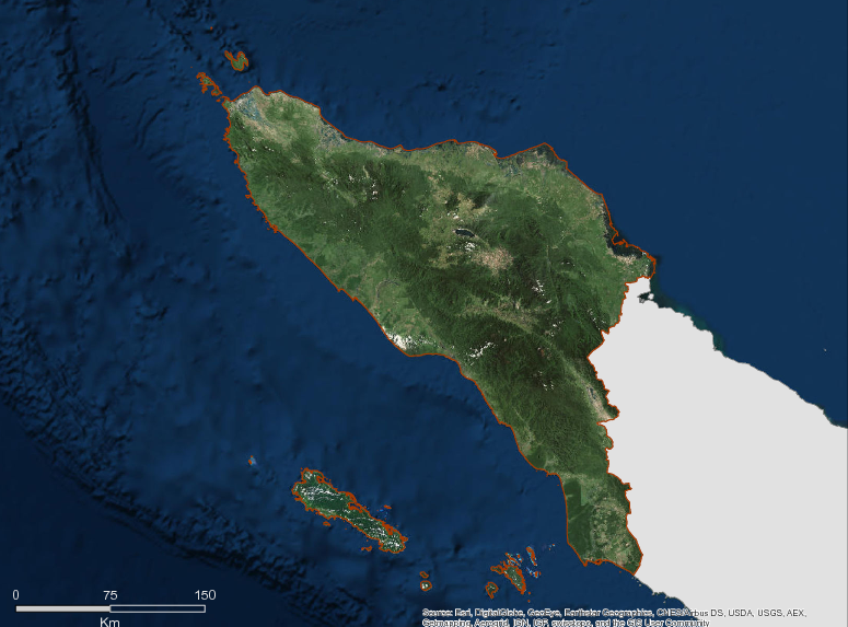

Description
Aceh lies between 20 and 60 degrees north of the equator at the extreme north of the Island of Sumatra and across the Strait of Malacca from Peninsular Malaysia. It is the most western province in Indonesia and has a unique history strongly embedded in a social structure reflecting the importance of Islam to the peoples’ day to day lives. Within a formal administrative structure common to Indonesia there is a system of informal leadership (mukim) which identifies local communities strongly held within religious bonds. These communities, with their religious base, are a strong part of Acehnese society. The Province was granted Special Autonomy in 2001. They are key agents mobilized by the Governor as part of the Province’s REDD initiatives for climate change mitigation and adaptation.
The Province occupies an area of almost 57 000 km² and supports a population of 4.3 million of whom most live in rural environments. The population is of mixed ethnic origin with original Acehnese complemented by communities from Java, elsewhere in Sumatra and ethnic Chinese. GDP in 2008 was USD 3.8 million of which the agricultural sector, including forestry and estate crops, contributed about USD 900 million. Aceh has been a major source of oil and natural gas production and this sector is still the main contributor to GDP. Mean per capita income is USD 881.3 with levels of poverty and the HDI similar to the national average.
As LNG production declines the government is focusing on a green development strategy. Green Aceh seeks to optimize the use of its hydro generating potential; implement sustainable forest management, retain and protect its lowlands for food production, to be mindful of the importance of waste management and land use to reducing disaster risk, and to carefully regulate the use of its non-renewable resources. This approach to an economic future with a low carbon footprint is consistent with national policy and underlies the Province’s commitment to sustainable use of its forests, reflected in a significant reclassification of forest use zones to Protection Forest and Conservation Reserves and a moratorium on commercial logging.
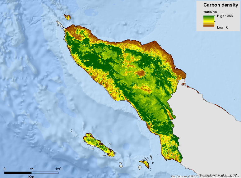
Prior to the introduction of commercial logging the estimated area of forest was just over 36 000 km². The remaining forest area of 33 400 km. Like Papua, Aceh has historically low rates of deforestation which attest to the difficulty of large scale logging in steep uplands and the impact of a long, armed struggle for independence. These low rates will influence the approach taken to establishing baselines for future carbon trade. Over 80% of the remaining forest area is designated for nature conservation and protection purposes, emphasizing the importance of developing non-destructive uses for the forests such as tourism and payments for environmental services, including REDD. Current estimates of the carbon sequestered in the forests of Aceh total 602 million tonnes CO₂e. The forests of Aceh contain the biggest remaining populations of Sumatran Rhino, tiger and orangutan. The Leuser Ecosystem Reserve and Ulu Masen Forest Reserve are globally significant forests and are seeking support from REDD investment in their future management.
Additional information can be found on the GCF Impact Platform.
Summary
Demographics
Urban vs. Rural Population
| Category | % | |
|---|---|---|
| Rural | 80.67 | |
| Urban | 19.32 |
Ethnic Groups
| Group | % | |
|---|---|---|
| Acehnese | 79.00 | |
| Gayo Lut | 7.00 | |
| Gayo Luwes | 5.00 | |
| Alas | 4.00 | |
| Singkil | 3.00 | |
| Simeulue | 2.00 |
Economy
GDP Breakdown
| Category | % | |
|---|---|---|
| Agriculture, Livestock, Forestry & Fisheries | 23.86 | |
| Trade, Hotel & Restaurant | 13.71 | |
| Mining & Quarrying | 9.96 | |
| Services | 9.85 | |
| Transport & Communication | 9.37 | |
| Construction | 8.61 | |
| Processing Industry | 7.54 |
Forest Status
Major Vegetation Types
| Category | km² | |
|---|---|---|
| Secondary Dryland Forests | 17,295 | |
| Primary Forest | 12,048 | |
| Shrubs | 6,901 | |
| Agriculture Dry land mixed | 5,703 | |
| Agriculture Dry land | 3,430 | |
| Rice fields | 3,198 | |
| Plantation | 1,839 | |
| Secondary Swamp Forest | 1,144 | |
| Savannah | 1,139 | |
| Swamp | 959 | |
| Open Ground | 884 | |
| Tambak | 716 | |
| Crops | 464 | |
| Water body | 324 | |
| Secondary Mangrove Forest | 294 | |
| Settlement | 219 | |
| Primary Swamp Forest | 98 |
Forest Management
| Category | km² | |
|---|---|---|
| Conserved Forest Area | 14,277 |
Drivers of Deforestation
According to Aceh’s Strategic REDD+ Action Plan (2014), the primary drivers of deforestation are:
- Weak compliance with the spatial structure
- Tenure conflicts
- Ineffective Forest management institutions
- Ongoing post-conflict livelihoods transformation
- Policy incentives and disincentives have not been implemented
- Government (Political Will)
- Conflicts over authority to regulate land use change
- Perceptions of forest areas and natural resources are administratively restricted
- Lack of alternative sources of wood
- Weak Law enforcement
Deforestation Rates
Notes
| a. | Due to different methodological approaches and base years, Forest Status data fields may differ slightly. Data sources for each field are listed below. |
Sources
| 1. | Aceh Dalam Angka 2014, Hal. 42 |
| 2. | BPS-SP 2012 Aceh, hal 113 |
| 3. | BPS 2016 |
| 4. | Aceh dalam angka 2012, BPS |
| 5. | Aceh Central Statistics Agency (BPS), Aceh dalam angka 2012 hal 493 link |
| 6. | Aceh dalam angka 2012 hal 350 , BPS |
| 7. | Ministry of Environment and Forestry 2018 |
| 8. |
Overview of Forest Monitoring and Measurement Systems
Aceh uses a forest monitoring system that detects forest cover using satellite imagery analysis continuously updated every 2 years. The Government of Aceh also routinely uses field-level validation as part of its forest management activities. Aceh also uses a data and information developed by Civil Society Organizations to help address conservation and management issues.
Reference Levels and Targets
Deforestation Rates
Sources
| 1. | Rio Branco Declaration, Based on National FREL |
| 2. | Ministry of Environment and Forestry 2018 |
Laws, Policies & Strategies
Policies and Strategies
Provincial REDD+ Action Plan (SRAP) – formalized on 21 January 2014 through Governor Regulation 3
Provincial Action Plan for the Reduction of GHG emissions (RAD-GRK) – Completed in 2011, the RAD-GRK provides a medium term action plan for reducing greenhouse gas emissions across sectors in Aceh through 2020.
Provincial long-term development plan (Rencana Pembangunan Jangka Panjang Daerah – RPJPD) – The RPJPD is a long-term development planning document for 20 years, from 2005 to 2025. It contains the vision, mission and direction of development in the province.
Aceh Moratorium on Logging – A fundamental policy enabling forest protection, the moratorium is founded on the principles of ‘redesign’, ‘reforestation’ and ‘reduction of forest degradation’.
Aceh Forestry Policy Redesign / TIPERESKA – Under this policy the TIPERESKA team is focusing on three main elements, these being: spatial planning, responsibilities / rights of the provincial government and institutional development. This team is responsible for providing recommendations for spatial planning, evaluation of concession permits and establishment of required task forces for the redesign of Aceh forestry policy.
Policy and Strategy on Reforestation in Aceh Province – First priority on revitalizing community plantation forestry. Secondary focus is on reforestation of degraded and marginal land.
Policy and Strategy on Law Enforcement Aceh – Continuous strategy involving relevant stakeholders undertaken on areas with a high risk of degradation and deforestation.
Policy on Evaluation on Forest Permits & Licenses Aceh – Focusing on the integration of all active licensed activities (including oil palm and mining) and evaluation of competency and cooperation. Results of this evaluation will become a reference for minimum investment and responsibilities for future concession holders.
Policy on Forest Protection and Conflict Resolution Systems Aceh – Forest protection system is being developed across three levels of Government, namely: Forestry Police in the Department of Forestry working with forest-crime units for training and operations, Forest Guard / Rangers whose function it is to patrol forest borders and Community Rangers, whose responsibility lies to protect that forest in the immediate vicinity of their villages.
Laws and Regulations
Aceh Governor Regulation no. 10 of 2017 – Addresses procedures to address land tenure conflict in Forest Areas
Governor Regulation no. 34 of 2016 – addresses procedures for granting site permits
Governor Regulation no. 20 of 2016 – addresses Forest Fire control in Aceh
Governor Regulation no. 3 of 2014 – formalizes the Strategy and Action Plan for Greenhouse Gas Emission Reduction from Deforestation and Forest Degradation
Qanun Aceh no. 19 of 2013 – addresses Spatial Planning in the the Province of Aceh
Governor Regulation 20/2013 on formation of technical implementation unit in the forestry agency that implements the activities in the forestry sector related to climate change.
Governor Regulation 85/2012 on the GHG emission reduction action plans as part of the national GHG emission reduction plans.
Institutional Framework
Provincial Environmental and Forestry Office – manages and overseeing issues related to the sectors of environmental management and forestry and climate change, including policy formulation.
Plantation Office – controls the use of land, plans, and issuance of permits non-forest.
Regional Development Planning Board (BAPPEDA) – coordinates the formulation of regional development planning policy with sustainable development and low carbon as its basis.
Zoning & Spatial Planning
Aceh Spatial Plan (RTRWA): In the governmental context, sustainable development vision should be referred to in the planning and implementation of Aceh future development. Provincial laws (local term: qanun) on spatial plan and on long-term development plan currently being discussed by the provincial legislature are designed based on the principles of sustainable and just natural resource management to generate benefits for Aceh communities. The Aceh Province Spatial Plan is based on the provincial bylaw 19/2013 that covers 2013 to 2033. The spatial plan has not been approved by the national government.
Engagement & Participation with Indigenous Peoples and Local Communities
The Aceh government recognizes the rights of indigenous and tribal peoples in forest management within the framework of existing laws and regulations. The recognition is carried out through the establishment of customary forest as one of the social forestry mechanisms recognized in national programs.
Since February 2018 the Provincial Government has encouraged districts and municipalities throughout the province to propose existing indigenous and tribal areas in the region to be recommended to the Ministry of Environment and Forestry of the Republic of Indonesia for adoption.
Related to forest management access for forest communities, Aceh Government through Qanun (Local Regulation) no. 7 Year 2016 on Aceh Forestry encourages community engagement mechanisms through the Forest Management Co-operation scheme as part of a Social Forestry program in accordance with Aceh’s own authorities. Access to these communities is implemented within the framework of forest management at the site level through a unit of forest management unit (FMU).
Partnerships and Ongoing Initiatives
Biodiversity Conservation and Climate Protection in the Gunung Leuser Ecosystem
- Description
-
The project supports the sustainable management of the Gunung Leuser ecosystem on Sumatra. The primary aim of the project is to balance the needs for conserving biodiversity with those of the population. The project provides infrastructure to the protected areas’ administrative bodies and advises them on setting up new structures and improving existing ones. New GIS systems boost the planning and monitoring ability of the regional planning authorities. The project works together with the municipalities to develop land-use plans in order to improve the living conditions of the local population and avoid conflicts. Borders are being defined between areas to be used by the population and protected ones. Measures involving agroforestry and communal forests create additional income for the population and reduce the pressure on land in the national park. Furthermore, the project addresses the conflicts between people and wild animals (e.g. elephants and tigers), with grant amount € 8,499,414.
- Partners
- KfW Entwicklungsbank
- Initiative Type
- Program
- Initiative Status
- Under implementation, will be end by 2020
KfW (Kreditanstalt für Wiederaufbau) Development Bank
- Description
-
This project is funded by the German government to the Government of Aceh for Biodiversity conservation and climate protection activities in Gunung Leuseur ecosystem.Based on the Letter of the Ministry of Finance no.S-103 / MK.7 / 2015 dated July 14, 2015 of EUR 4,194,714 Or Rp.67.115.424.000
With details:
2016 – EUR 300,000
2017 – EUR 1,429,714
2018 – EUR 1,621,000
2019 – EUR 844,000
The project focuses on South Aceh district, Kota Sebulussalam and Aceh Singkil regency, or in the district directly adjacent to Gunung Leuser Aceh National Park.
- Partners
- KfW
- Funding Source
- KfW
- Funding Amount
- EUR 4,194,714
- Initiative Type
- Technical Assistance Partnership
- Initiative Status
- Ongoing
Support to Indonesia's Climate Change Response – Technical Assistance Component (SICCR-TAC)
- Description
-
The project is financed by the EU of 6.5 million USD, with GIZ as the Executing Agency.The objectives of this project are the coordination of FMU capacity, the development of climate change campaigns in the regions as well as the need for the management of forest protection for FMU areas 1,2,4 and Tahura forests in Aceh Province.This project will run until 2019.
- Partners
- GIZ
- Funding Source
- GIZ
- Funding Amount
- $6.5 million USD
- Initiative Type
- Technical Assistance Partnership
- Initiative Status
- Ongoing
Support to Indonesia's Climate Change Response-Technical Assistance Component (SICCR-TAC)
- Description
-
Support to Indonesia’s Climate Change Response – Technical Assistance Component (SICCR-TAC) is a partnership between the Government of Indonesia and European Union (EU) in addressing climate change. The project is implemented under the auspices of the Ministry of Environment and Forestry, represented by the Directorate General of Climate Change. SICCR-TAC began in February 2016 and will be completed in January 2019.
The overall objective of the project contributes, in an effective and coherent way, to the achievement of the REDD+ strategy by designing provincial REDD+ strategies and mainstreaming them into existing development planning frameworks.
The project will design strategies to generate valuable experiences for further regional and national discussions by contributing lessons learned from the field to the national and international exchange on REDD+ experiences.
The focus of the project is on building the capacity of the Government of Aceh in its effort towards low-carbon/low-emission economic development in the Land Use, Land Use Change and Forestry sector. The Environment and Forestry Services of Aceh Province is main local stakeholder. One of the project’s main activities is strengthening Forest Management Units (FMU) as local units for sustainable forest management in Aceh.
SICCR-TAC is implemented by GIZ together with the consortium partners SNV Netherlands Development Organisation and AHT Group, with grant amount € 6.5 million.
- Partners
- GiZ, SNV Netherlands, and AHT Group
- Initiative Type
- Program
- Initiative Status
- Under Implementation, will be end on December 2018
Supports the Government of Indonesia to reduce greenhouse gas (GHG) emissions and conserve biodiversity in carbon rich and biologically significant forest and mangrove ecosystems
- Description
-
Tetra Tech is implementing the U.S. Agency for International Development (USAID) LESTARI project, which supports the Government of Indonesia to decrease greenhouse gas (GHG) emissions and conserve biodiversity in carbon-rich, biologically significant forest and mangrove ecosystems.
Deforestation and forest degradation in Indonesia are a result of a complex dynamic of political, economic, and institutional drivers. On three of Indonesia’s largest islands, Tetra Tech’s project activities target six strategic areas including Aceh, Central Kalimantan, and Papua landscapes.
Through LESTARI, Tetra Tech applies a landscape approach that combines conservation objectives and low emissions development strategies. This approach improves land use governance, enhances protected areas management and protection of key species, and increases commitment from the private sector for more sustainable business practices.
Working with key private sector, government, and community stakeholders, the LESTARI project has resulted in an increase of policies, laws, regulations, and procedures to support low emission development, forest conservation, and sustainable forest management to be enforced at all levels. Tetra Tech has helped develop models for successful integration of district, provincial, and national low emissions development and forest conservation strategies, which also have been shared at all levels of government and with other key stakeholders.
LESTARI’s influence resulted in the introduction of three public policies that address the changing climate and biodiversity. In addition, 971 people received training in natural resource management and 120,551 people were reached with targeted information about project activities.
Tetra Tech has helped LESTARI reclaim more than 8 million hectares of forest and put them under improvement management, including the critical orangutan forest habitat, which reduces the threat of poaching.
LESTARI also assisted with a 41 percent decrease in CO2-equivalent emissions, helping Indonesia decrease GHGs and increase forest and key species conservation.
- Partners
- Tetra Tech – USAID Lestari
- Initiative Type
- Program
- Initiative Status
- Under Implementation, will be end by 2020