Central Kalimantan, Indonesia
Indonesia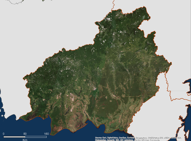
Description
Spanning 153,564 km2, Central Kalimantan is Indonesia’s third largest province. Central Kalimantan became Indonesia’s fifth full member of the GCF when it joined in 2010. With just 2.2 million inhabitants, population density is low. The province is sub-divided into 13 Districts with 1572 urban and rural villages. Overall 67% of the population live in rural areas, where villages tend to be distributed along the banks of the 11 large rivers which flow from the central mountains to the Java Sea. The largest ethnic group are the indigenous Dayaks, but there are significant numbers of official and economic migrants from Java, Bali and Sulawesi in both rural and urban settlements. Poverty remains a major issue particularly in rural areas because of the difficulty and cost of transportation and communication and the impact that this has on basic human services delivery. Education and health services in areas outside the provincial capital, Palangkaraya, are poor and this is reflected in the province’s Human Development Index (HDI).
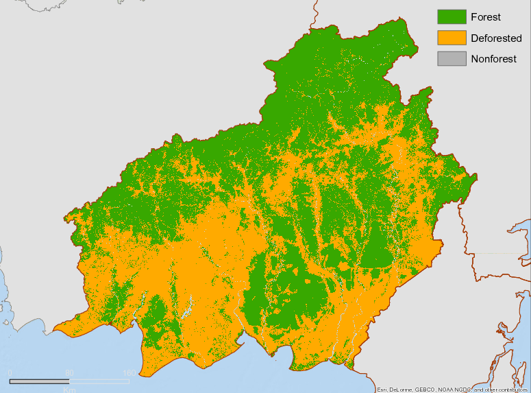
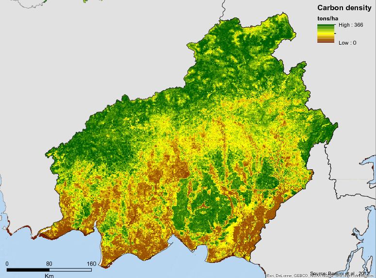
Despite its low population density, Central Kalimantan has suffered serious and widespread environmental degradation. From 1996 to 1999 it was the site of the so-called “Mega Rice” project which cleared one million hectares of peat swamp forests and constructed 4000 km of canals to drain the peat. The lingering legacy of this project has been persistent peat drainage in the dry season, leading to high GHG emissionsfrom oxidation and compounded by annual dry season fires. Central Kalimantan has about 3 million hectares of peat soils, equaling those West, East and South Kalimantan combined. The extent of the impact of the clearing of swamp forests for agriculture and estate crops is demonstrated by official forest cover figures, which show only 865,000 ha of swamp forest remaining compared to 1.4 million ha of secondary forest and a further 1.1 million ha of degraded shrubland. Of the original area of peatlands, 80% is under threat from seasonal fire and/or oxidation. Restoration of the damaged peat ecosystems is a high priority for the provincial government and is also identified as a priority via Presidential Decree (2016).
Management of the province’s remaining forests is subject to on-going discussion and planning. Although 12.6 million ha remain within the national forest estate, a further 2.8 million ha are currently zoned in other land use categories, according to the provincial spatial plan. Proposed changes to the spatial zoning plan would greatly increase the proportion of these standing forests within the Protection Forest category, since their role in hydrologic regulation and reduced soil carbon emissions are regarded as critical. For over a decade, Central Kalimantan has been pursuing a low carbon development strategy in line with national policies. In 2010, Central Kalimantan was chosen to serve as a pilot Province for REDD+ development under an agreement between Norway and Indonesia to reduce deforestation. In 2005, the provincial government established a “green” policy framework which evolved in 2010 to a vision of Central Kalimantan as a “Green and Clean Province”. The province is also the site for the Australia-Indonesia Forest Carbon Partnership REDD+ Demonstration Project which aims to reduce emissions on 135,000 ha of degraded peatlands. It also hosts a number of other private investment REDD+ Projects and is a participant in the Heart of Borneo trans-boundary conservation project.
Additional information can be found on the GCF Impact Platform.
Summary
Demographics
Urban vs. Rural Population
| Category | % | |
|---|---|---|
| Rural | 66.54 | |
| Urban | 33.46 |
Ethnic Groups
| Group | % | |
|---|---|---|
| Banjarese | 24.00 | |
| Other | 22.00 | |
| Javanese | 18.00 | |
| Ngaju | 18.00 | |
| Dayak | 10.00 | |
| Bakumpai | 8.00 |
Economy
GDP Breakdown
| Category | % | |
|---|---|---|
| Agriculture, Livestock, Forestry & Fisheries | 28.50 | |
| Trade, Hotel & Restaurant | 20.80 | |
| Services | 13.40 | |
| Mining & Quarrying | 9.60 | |
| Transport & Communication | 8.20 | |
| Processing Industry | 7.40 | |
| Construction | 5.50 |
Forest Status
Major Vegetation Types
| Category | km² | |
|---|---|---|
| Secondary Dryland Forests | 44,062 | |
| Shrubs | 31,424 | |
| Crops | 19,939 | |
| Secondary Swamp Forest | 18,019 | |
| Plantation | 17,315 | |
| Primary Dry Forest | 10,880 | |
| Gardens / Plantations | 1,924 | |
| Primary Swamp Forest | 396 | |
| Secondary Mangrove Forest | 247 | |
| Primary Mangrove Forest | 16 | |
| Savannah | 2 |
Forest Management
| Category | km² | |
|---|---|---|
| Production Forest | 38,622 | |
| Limited Production Forest | 32,890 | |
| Conversion Production Forest | 25,210 | |
| Conservation Areas | 15,889 | |
| Protected forest | 13,198 |
Drivers of Deforestation
The main drivers of deforestation are large-scale permanent cultivation (primarily palm oil and timber plantations) and smallholder agriculture. Fire is also an important driver of forest degradation in the province.
Deforestation Rates
Notes
| a. | Due to different methodological approaches and base years, Forest Status data fields may differ slightly. Data sources for each field are listed below. |
Sources
| 1. | 2014, Strategi Daerah REDD+ Kalimantan Tengah |
| 2. | BPS,Kalteng dalam angka 2014 |
| 3. | BPS,Kalteng dalam angka 2012 |
| 4. | |
| 5. | BPS, 2016 |
| 6. | http://kalteng.bps.go.id/linkTableDinamis/view/id/142 |
| 7. | 1973 |
| 8. | Ministry of Environment and Forestry 2018 |
Overview of Forest Monitoring and Measurement Systems
At the national level, Indonesia’s National Forest Monitoring System (http://nfms.dephut.go.id/) is a platform which contains information about satellite imagery, land cover, deforestation, potential forest resources and hotspot. This platform was developed as part of Indonesia’s commitments under the UNFCCC.
At the provincial level, a plantation monitoring system has been designed and implemented by the provincial government. The Information and Performance Monitoring System for Sustainable Plantation Performance (SIPKEBUN) (http://monitoring.inobu.org) is used to store and display independent smallholder data in a way that allows government managers to easily access data and monitor plantations. is the platform’s analysis section permits display information of deforestation and active fire data.
Reference Levels and Targets
Deforestation Rates
Sources
| 1. | Rio Branco Declaration, based on national FREL |
| 2. | Ministry of Environment and Forestry 2018 |
Laws, Policies & Strategies
Policies and Strategies:
Central Kalimantan Local Action Plan for Reducing Greenhouse Gas (RAD-GRK) 2012 – Completed in 2011, the RAD-GRK provides a medium term action plan for reducing greenhouse gas emissions across sectors in Central Kalimantan through 2020.
Provincial REDD+ Strategy (STRADA) 2012 – the document covers the relation between the national and provincial emissions reduction, the issues of deforestation and forest degradation in the province, the REDD+ strategies and action plans, MRV and mainstreaming these into the development activities.
Provincial Long-Term Development Plan (Rencana Pembangunan Jangka Panjang Daerah – RPJPD) – The RPJPD is a long-term development planning document for 20 years, from 2005 to 2025. It contains the vision, mission and direction of development in the province.
Central Kalimantan Roadmap to Low-Deforestation Rural Development 2013 – This roadmap summarizes a plan for reducing deforestation while increasing palm oil production and elevation rural incomes of smallholder families. The goal is to eventually establish Central Kalimantan as a an environmentally responsible source of palm oil.
Laws and Regulations
Governor Decree (49/2015) – revokes Governor’s regulation52/2008 on Guidelines for Land Opening and Yard for People in Central Kalimantan Environment and Governor Regulation 15/2010 about Amendment of Governor Regulation of Central Kalimantan 52/2008. Both revoked regulations permitted people to set fire in certain areas.
Governor Decree (05/2015) – In 2015 the province enacted the spatial plans for 2015-2035 which regulates the land use for all development sectors.
Governor Decree (42/2014) – on conflict resolution related to commercial plantations in Central Kalimantan province
Governor Decree (41/2014) – on the management of high conservation value (HCV) forests in the plantation areas for the protection of biodiversity, environmental services, social, and cultural.
Governor Decree (36/2012) – on provincial action plan to reduce the GHG, this covers several sectors, namely: agriculture, forestry and peat, energy and transportation, industry, waste, and others.
Provincial Regulation 5/2011 – on the establishment of sustainable commercial plantations.
Governor Decree (660/945/BLH/IV/2011) – decree forming a provincial commission for REDD+ whose functions include coordinating the local strategy arrangement, implementing activities, prepare funding instruments and mechanism, establishing the MRV agency, and monitoring the Presidential decree on moratorium of forestry permits.
Provincial Regulation 4/2010 – Updating the provincial long term development plan for the period 2005-2025
Governor Decree 13/2009 jo.
4/2012 – on Indigenous Lands, Land use and Resource Rights in Central Kalimantan province
Institutional Framework
Provincial Commission on REDD+ – Created in 2011 as a coordination, communication, harmonization, and implementation body to facilitate REDD+ activities in the province. The body is chaired by the Governor and composed of representatives of different agencies related to land use and climate change. The commission’s tasks include: coordination of REDD+ strategies establishment; implementation of REDD+ activities; formation of MRV agency; and, implementation of the Presidential Decree on the forestry permit moratorium.
Forestry Agency – manages and oversees forestry sector-related issues, including policy formulation.
Plantation Agency – controls land use, planning, and issuance of permits in non-forest areas.
Environmental Agency – authorizes the protection and management of the environment, including climate change-related issues.
Provincial Development Planning Agency (BAPPEDA) – coordinates policy formulation for regional development planning, with sustainable development and low carbon as the basis.
Zoning & Spatial Planning
Central Kalimantan’s Spatial Plan was formalized by the provincial bylaw 5/2015. It covers the period of 2015-2035. The spatial plan represents an effort to organize spatial management through the authority of the Central Kalimantan Provincial Government, to guide development by regional governments, communities and the private sector to promote sustainable and environmentally friendly development. The plan is available for download here.
Engagement & Participation with Indigenous Peoples and Local Communities
In March 2018, the Central Kalimantan Provincial Government began mapping 12 indigenous (adat) areas comprising a total area of 119,778 ha. The identification process intrinsic to the mapping will accelerate the recognition of indigenous (adat) forest. Based on Central Kalimantan Provincial Forest Agency data, only 77,560 ha of social forestry of the planned 1.5 million ha (by 2019) has been realized to date.
Partnerships and Ongoing Initiatives
— Unnamed Initiative —
- Description
-
DGM Indonesia focuses on supporting activities related to the certainty of rights to land and natural resources as well as community-based and sustainable management. In addition, this funding can also be used to explore options for tenure instruments that take advantage of opportunities provided by the government (including the capacity building of indigenous peoples and local communities in carrying out selected options). In addition to the above activities, funding support for activities related to improving the livelihoods of indigenous peoples and local communities is also open to support selected tenure security options. To guarantee the participation and community ownership of the activities carried out, DGM Indonesia requires grantees to disseminate information, disseminate information to the community, FPIC or the like before implementing the project.
- Partners
- AMAN, Papua Institute for Indigenous Peoples Strengthening Studies (LSPK); Papua Arrow Association;, Limited Association for the Study and Empowerment of Indigenous Peoples (PtPPMA), LBBT Consortium
- Initiative Type
- indigenous peoples initiative
- Initiative Status
- Implementation
Development of Standard Operating Procedures (SOP) on the Handling and Resolution of Tenurial Conflicts in Plantations
- Description
-
Land based SOP conflicts passed into Regional Regulations or Governor Regulations.
The Partnership is involved in furtherance of a policy in the form of Standard Operating Procedures (SOP) regarding the handling and resolution of conflicts tenure at the plantation in response to the Sustainable Plantation Regional Regulation and Governor Regulation No.42 year 2014 on the Handling and Settlement of Plantation Conflict in Central Kalimantan Province.Based on the SOP, a flowchart of conflict handling and conflict resolution and the flowchart of tenurial conflict handling and resolution mechanisms in oil palm plantations in Central Kalimantan was established.The flow chart has been clearly defined in the process of handling and resolving conflicts, starting with the occurrence of conflicts by individuals, communities or agencies, followed by data collection and social mapping and conflict analysis to identify the feasibility of the complaint.If the results of the data screening and conflict analysis indicate that the complaint is not feasible to be followed up, then the file will be returned to the complainant for correction or completion.However, if the complaint is declared feasible to be followed up, a problem solving recommendation may be made, which may be law enforcement, mediation, negotiation and policy recommendations.This policy recommendation can be a partnership, compensation, enclave and revision of boundary or spatial planning.
- Partners
- Kemitraan
- Initiative Type
- Technical Assistance Partnership
- Initiative Status
- In Discussion
Ecosystem Restoration Programs
- Description
-
Ecosystem Restoration (ER) program was initiated by PT. Rimba Raya Conservation (RRC) in 2007. The objective of the program is to create activities related with the Climate Change prevention, biodiversity and rural community development. ER socialization program has been implemented respectively by PT RRC and PT RRC’s partner, World Education (WE), and also performed collaboratively by PT RRC and WE.
- Partners
- PT. Rimba Raya Conservation; World Education (WE)
- Initiative Type
- Public-private partnership
- Initiative Status
- Under implementation
Expanded Unilever- District-Smallholder Partnership
- Description
-
In 2015 Unliver announced it would take a jurisdictional approach to sourcing commodities from regions with strong climate and forest policies.As part of the initiative Unilever signed a three-year Memorandum of Understanding (MoU) with the provincial government of Central Kalimantan, the district government of Kotawaringin Barat and Yayasan Penelitian Inovasi Bumi (INOBU) to support a jurisdictional approach for sourcing sustainable palm oil at village level.The partnership aims to map palm oil smallholders and boost smallholder certifications and conduct a baseline assessment of existing smallholder organizations.The partners are now discussing an investment of USD 1 million to support these efforts.
- Partners
- Unilever, INOBU
- Funding Source
- Unliver
- Funding Amount
- $1 million to support farmers
- Initiative Type
- Private investment and Jurisdictional Sourcing
- Initiative Status
- In Discussion
Heart of Borneo (H0B) Initiative
- Description
-
The Heart of Borneo (HoB) Initiative is a transboundary collaboration established in February 2007 among the governments of Brunei, Indonesia and Malaysia to enable conservation and sustainable development that improves the welfare of those living on the island while minimizing deforestation, forest degradation and the associated loss of biodiversity and ecosystem services. Under this Initiative, the three countries involved have committed 355,000 hectares, 16.8 million hectares and 6 million hectares respectively to be included in the HoB. The commitments of the three HoB governments are contained in the Heart of Borneo Declaration.
The HoB Initiative is government-led and NGO-supported programme. WWF is the lead NGO which also in collaboration with WWF-Malaysia and driven by support from WWF offices around the world.
- Partners
- WWF; National governments of Indonesia, Malaysia and Brunei Darussalam
- Initiative Type
- Landscape Initiative project; Government Initiative
- Initiative Status
- Under implementation
Information & performance monitoring system for sustainable plantations (SIPKEBUN)
- Description
-
SIPKEBUN, which was developed by INOBU in collaboration with the Ministry of Agriculture, the provincial and three district governments of Central Kalimantan, is an online system that integrates data and maps of all oil palm growers: from industrial scale estates to independent smallholder farmers. SIPKEBUN enables the government to know who is growing oil palm, where they are growing it and how they are growing it. SIPKEBUN also a powerful tool for governments to support smallholders to farm legally, productively and profitably. The system can help smallholder farmers to get cultivation registration letters. The data stored within SIPKEBUN enables local governments to streamline the process for issuing cultivation registration letters to smallholders. This data is also a stepping stone for initiating processes for issuing land certificates to smallholders. SIPKEBUN enables local governments to understand how smallholders are farming, which enables them to more effectively target interventions for improving the productivity and profitability of smallholder oil palm plantations.
- Partners
- Ministry of Agriculture, Provincial government of Central Kalimantan; Three district governments and, INOBU
- Initiative Type
- Technical Assistance Partnership
- Initiative Status
- Under implementation
Katingan Mentaya Project
- Description
-
Katingan Mentaya Project is a living proof that carbon finance can combat climate change. The largest program of its kind, it generates an average 7,5 million triple gold certified carbon credits annually. In partnership with local communities, the project utilizes carbon revenues to ensure natural forest restoration and protection through activities aligned to the UN Sustainable Development Goals.
- Partners
- PT. Rimba Makmur Utama
- Initiative Type
- Finance provision initiative
- Initiative Status
- Under implementation
Peatland Restoration
- Description
-
Peatland Restoration Agency (BRG) mandated to restore 2 million ha of degraded peatland in 7 provinces by 2020 (60% of BRG project area located in Central Kalimantan). BRG will restore 679.573 hectares of peatlands in Central Kalimantan. The restoration will be carried out within five years from 2016 to 2020, especially in the heavily degraded areas in Pulang Pisau District.
- Partners
- Peatland Restoration Agency; Pulang Pisau District
- Initiative Type
- Government initiative
- Initiative Status
- Under implementation
PELITA Seruyan Agricultural Facility
- Description
-
PELITA Seruyan Agricultural Facility aims to reduce environmental damage while improving the welfare of farmers to independently, sustainably and productively cultivate oil palm. The district governments of Seruyan with the support of INOBU, financed by Norad, Packard Foundation and UNEP, has established an agricultural facility for supporting all oil palm smallholders in the entire district. The facility currently provides training for smallholders and will start providing agricultural inputs in the coming year, including certified seedlings, fertilizers and pesticides. It provides support for farmers to get RSPO and ISPO certification. The facility partners with companies, local government agencies and civil society organizations. It would charge at-cost fees for goods and services, and also be capable of receiving grants from third parties and local governments.
- Partners
- Seruyan District Government;, Oil Palm Mills and Buyers; RSPO and Farmer Groups.
- Initiative Type
- Technical Assistance Partnership
- Initiative Status
- Under implementation
Plantation Conflict Monitoring System
- Description
-
Online Based monitoring system that can track tenurial conflicts in the plantation area in Central Kalimantan.
Yayasan Penelitian Inovasi Bumi (INOBU) has conducted a preliminary study to identify the typology of social conflict occurring within the industry, particularly in West Kotawaringin and Seruyan District, Central Kalimantan Province, as well as mechanisms for completion, monitoring and prevention of conflicts implemented by District and Provincial Governments.The results of the study will be used to design a tracking system of conflict resolution developments that occur at every level of government integrated with plantation databases.The system hopes to help the district and provincial governments to monitor and encourage the process of conflict resolution at the local level and improve the handling of conflict ahead.
- Partners
- INOBU
- Initiative Type
- Technical Assistance Partnership
- Initiative Status
- In discussion
Production and Protection Approach to Landscape Management (PALM)
- Description
-
Funded by the Norwegian Climate and Forest Initiative (NICFI), Phase II began in mid-2016 and will end in 2020 with a focus on Kotawaringin Timur and Katingan Districts. The program’s main areas are:
-
Fiscal policy for sustainable land use management at sub-national level to support local government on sustainable and equitable land use management including to promote high productivity, sustainable agricultural production (particularly oil palm) and protection of high value ecosystems.
-
Policy engagement with key local decision makers with engagement of private sector and civil society organizations to develop framework for adopting sustainable land use policies in oil palm supply chain.
-
Business models of sustainable alternative livelihoods for smallholder farmers in two selected districts to help improve local economy and optimize land use.
-
Local institutional capacity to support production-protection strategy through productive research-policy linkages and public-private-people collaboration.
-
- Partners
- Climate Policy Initiative, University of Palangkaraya, and PILAR
- Initiative Type
- Technical Assistance Partnership
- Initiative Status
- Under implementation