Papua, Indonesia
Indonesia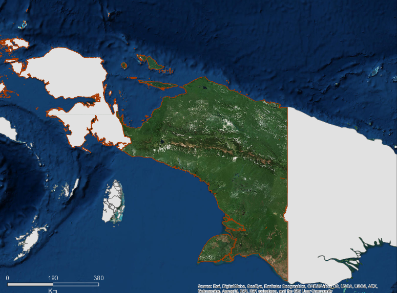
Description
Tanah Papua is the western part of the large island of New Guinea, as the largest island in Indonesia is divided into two regional governments – the Papua Province covering an area of 316.553.07 km2 (CBS, 2013) of which approximately 80% is forest; and the Papua Barat Province covering an area of 97,117 km2 of which approximately 90% is covered in forest.
As the largest island in Indonesia Papua is blessed with natural wealth and extraordinary diversity of ecosystems, which are contained in the forest, coastal and marine, as well as mineral resources. Papua’s biodiversity is half of Indonesia’s biodiversity, particularly the endemic flora and fauna that is only found on this island. Papua is home to 15.000-20.000 plant species (55% endemic), 2000 species of orchids, 602 species of birds (52% endemic), 125 species of mammals (58% endemic) and 223 species of reptiles and amphibia (35% endemic), 25 species of freshwater fish and 1200 species of marine fish as well and an estimated 150,000 species of insects (Papua Ecology, 2013).
Papua’s rich natural resources and its uniqueness in terms of biology and biogeography characteristics and culture which has about 250 languages, is a capital asset for the development of green economy.
In the course of the development processes, the rich natural resource’s potentials are facing pressures due to environmental degradation and extinction of biodiversity and its ecosystem. This threat is caused, among others by deforestation, conversion of forest into agriculture and monoculture plantations and illegal logging.
The rate of deforestation and degradation in Papua continues to increase every year as pressures are faced from land conversion and illegal logging. Unplanned deforestation and forest degradation has contributed towards the increase of greenhouse gas (GHG) emissions and contributed to global climate change.
As a commitment of the Government of Papua Province to carry out the National GHG Emission strategy that was based on the RAN GRK (Presidential Decree No 61/2011), and concurrently, in accordance with the Paris Agreement in which the handling of climate change must be implemented in the context of Sustainable Development and Poverty Reduction goals, (Presidential Regulation no. 59 of 2017), the province felt the previously established NATIONAL & PROVINCIAL ACTION PLAN FOR REDUCTION OF GHG EMISSIONS (RAN – GRK and RAD – GRK) were no longer valid in accommodating the achievement of national development targets. These targets include economic growth, poverty reduction and reducing of GHG emissions, as well as mainstreaming climate change issues into development planning and at the same time securing GHG emission reduction targets of 26% by 2020 and 29% by 2030.
Therefore, the Provincial Government of Papua took steps to review and revise the previous Provincial Action Plan for Reduction of GHG Emission (RAD GRK) documents and established the Provincial Action Plan for Reduction of GHG Emissions (RAD GRK) in 2017 that will be used as the basis for the preparation of Low Development Carbon Plans (PPRK) and encourage the establishment of “Green Development Policies” at the sectoral and regional levels and to be integrated into RPJMN (National Mid-Term development Plans) and RPJMD (Provincial Mid-Term Development Plans). The rate emission by the mitigation action plans for Papua Province found in the RAD GRK document, will be included in the total national plan for the mitigation of emission (INDC) towards 2030.
The initiative to establish the Task Force for Low Carbon Economy Development in Papua since 2010 by Gubernatorial Decree No.105/2010 until 2017 has been a very essential approach to act as a catalyst in supporting NGO’s and Government Institutions in the development Low Carbon Economies in the province, this however is recently changed into Regional Commission for Climate Change and Sustainable Development (RC3SD) or Komisi Daerah Perubahan Iklim dan Pembangunan Berkelanjutan (KOMDA PIPB) by Gubernatorial Decree No: 188.4/69/YEAR 2018 dated 8 Feb 2018.
More information can be found on the GCF Impact Platform.
Summary
Demographics
Urban vs. Rural Population
| Category | % | |
|---|---|---|
| Rural | 90.99 | |
| Urban | 9.01 |
Ethnic Groups
| Group | % | |
|---|---|---|
| Other | 23.34 | |
| Dani | 23.30 | |
| Auwye/Mee | 11.32 | |
| Javanese | 8.38 | |
| Biak-Numfor | 5.25 | |
| Ngalik | 4.80 | |
| Asmat | 4.42 | |
| Dauwa | 3.49 | |
| Buginese | 3.20 | |
| Yapen | 2.64 | |
| Toraja | 1.73 | |
| Ketengban | 1.50 | |
| Moni | 1.49 | |
| Makassarese | 1.48 | |
| Marind Anim | 1.33 | |
| Ambonese | 1.24 | |
| Butonese | 1.10 |
Economy
GDP Breakdown
| Category | % | |
|---|---|---|
| Mining & Quarrying | 52.72 | |
| Agriculture, Livestock, Forestry & Fisheries | 11.72 | |
| Construction | 10.66 | |
| Services | 8.42 | |
| Trade, Hotel & Restaurant | 5.94 | |
| Transport & Communication | 5.76 | |
| Processing Industry | 1.86 |
Forest Status
Forest Management
| Category | km² | |
|---|---|---|
| Protected forest | 78,152 | |
| Conserved Forest Area | 67,362 | |
| Limited Production Forest | 59,612 | |
| Production Forest | 47,393 | |
| Conversion Production Forest | 41,163 | |
| Non-Forest Area - Others | 23,695 |
Drivers of Deforestation
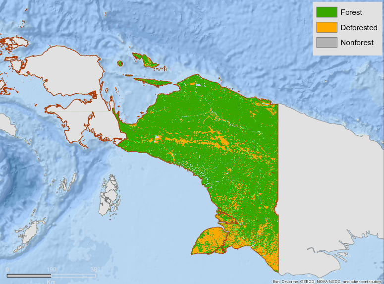
Papua’s Strategic REDD+ Action plan identified deforestation in different categories of forest: 77,051.14 ha/year in Production Forests, 29,853.24 ha/year in Limited Production Forests,27,864 ha/year in Converted Production Forests, 13,502.08 ha/year in Protected Forests, and 10,661.40 ha/year in Reserves/Conservation Areas.
While it is normal that forest degradation occurs in production forests as they are designated to produce timber, the data also show massive forest encroachment in protected forests and conservation areas. The overlay with the map of conservation areas in the province shows conservation areas with the highest rate of degradation is Mamberamo Foja Reserve and Lorentz National Park that see average annual deforestation rates of 7,218.05 ha/year and 1,525.93 ha/year respectively. This proves that designating a given area as a conservation area does not limit accessibility to performing illegal logging in the area. Increasing demand for wood to support the development of public facilities and settlements due to establishment of new districts/villages is one of the drivers for the massive deforestation. In addition, easier access to areas that used to be isolated also contributes to the massive deforestation.
In Papua, deforestation only contributes 12.6% to net emission, while forest degradation contributes 64.1%. This shows that actions to prevent forest degradation must be given priority.
Deforestation Rates
Notes
| a. | Due to different methodological approaches and base years, Forest Status data fields may differ slightly. Data sources for each field are listed below. |
Sources
| 1. | Strategic Action Plan for REDD (SRAP) 2014 |
| 2. | MoEF- Dept of Forest Planning-2015 |
| 3. | |
| 4. | Data tahun 2011, Papua dalam Angka 2012, BPS, h.91 |
| 5. | Sensus Penduduk BPS Papua 2010 link |
| 6. | |
| 7. | Data tahun 2011, Papua dalam Angka 2012, BPS, h.595 |
| 8. | Data tahun 2011, Papua dalam Angka 2012, BPS, h.616 |
| 9. | 1. RTRWP/SRAP |
| 10. | Tutupan hutan tahun 2003, Buku Statistik Kehutanan 2012, Tabel 2.2, h.23 |
| 11. | MOEF 2015 |
| 12. | Ministry of Environment and Forestry 2018 |
| 13. | SRAP REDD+ Papua 2014 |
Overview of Forest Monitoring and Measurement Systems
A number of stakeholders, primarily government institutions, play a role in monitoring actions to reduce greenhouse gas emissions. Key institutions and their responsibilities include:
| District /Municipality | Institution | Responsibilty |
| 1 | Bappeda (Provincial Dev Planning Board) | Coordinator of MRV for RAD-GRK in Papua Province |
| 2 | Provincial Forestry Department | Carry the Responsibility for the program implementation and to provide data on Forestry and Peatland |
| 3 | Dept of Food Crops & Horticulture | Carry the Responsibility for the program implementation and to provide data on agriculture, animal husbandry and cash crops |
| 4 | Dept of MiningEnergy | Carry the Responsibility for the program implementation and to provide data on energy and mining |
| 5 | Dept of PublicTransportation | Carry the Responsibility for the program implementation and to provide data on public transportation facilities |
| 6 | Dept Public Works & Construction | Carry the Responsibility for the program implementation and to provide data on waste management |
| 7 | Dept of Environmental Management | Carry the Responsibility for the program implementation and to provide data on waste management |
| 8 | Bappeda (District/Municipaluty Dev Planning Board) | Coordinator of MRV for RAD GRK at district and municipality |
| 9 | District / Municipality Forestry Dept | Carry the Responsibility for the program implementation and to provide data on Forestry and peatland at the District/Municipality Level |
| 10 | District/Municipality Dept of Agriculture | Carry the Responsibility for the program implementation and to provide dataagriculture, animal husbandry and cash crops at District and Municipality |
| 11 | Distirict Dept of Energey and Mining | Carry the Responsibility for the program implementation and to provide dataenergy at District and Municipality |
| 12 | District Dept of Public TRansporttion | Carry the Responsibility for the program implementation and to provide data on public transportation at District/Municipality |
| 13 | District Dept of Public Works & Cosntrution | Carry the Responsibility for the program implementation and to provide dataon Waste Management at District/Municipality |
| 14 | District Dept of Environmental Management | Carry the Responsibility for the program implementation and to provide data on waste management at District/Municipality |
| 15 | District Dept of Environmental Sanitation | Carry the Responsibility for the program implementation and to provide dataon environmental management of waste and sanitation at District/Municipality |
The mechanism of MRV in Papua Province will work as follows:
- At the mid of the 3rd quarter (end of August), the Gov’t Institutions at district / municipality shall closely monitor and evaluate the implementation of the activities related to Low Carbon Emission Development programs that are being carried out by the related Dept/Institutions. The data and information on the results of monitoring and evaluation are presented in the General Sheet and Technical Sheet of each field (see PEP Technical Instruction Manual of PPRK Implementation). The data and information shall be submitted in the first week of September to the Head of the Bappeda of the District/Mnicipality.
- Heads of District / Municipalilty Bappeda hold coordination meetings together with related Gov’t Departments to review data and information on monitoring and evaluation results. The Head of Bappeda then submits a report to the Regent / Major. Furthermore, the REGent/Major shall report to the Governor.
- At the end of the third quarter (end of September), the provincial level Gov’ Departments shall conduct monitoring and evaluation of the implementation of RAD-GRK activities in accordance with their respective functions and authorities. Data and information on monitoring and evaluation results are presented in the MRV Online system of the RAN-GRK Secretariat.
- Head of Bappeda (Prov Planning Board) conducts coordination meetings with relevant Gov’t Institutions to review the data and information on the results of monitoring and evaluation that have been carried out. Then the Head of Bappeda approves the reports in the PEP (MRV) on-line system and also submits also a hard copy of the report to the Governor.
Reference Levels and Targets
Deforestation Rates
Sources
| 1. | SRAP Papua 2013 |
| 2. | Rio Branco Declaration, based on National FREL |
| 3. | Ministry of Environment and Forestry 2018 |
Laws, Policies & Strategies
Strategies and Policies
Provincial REDD+ Action Plan (SRAP) – completed in 2013, providing an overview the condition of the provinces forests, vision, mission, primary forest management issues, implementation strategies and measures, monitoring, reference emission level, and mitigation actions.
Provincial Action Plan for the Reduction of GHG emissions (RAD-GRK) – Papua’s RAD-GRK outlines actions that will be implemented in Papua Province through 2020. The formulation of RAD-GRK of Papua Province was conducted through cooperation between Provincial Natural Resources and Environmental Management Agency Papua with the Faculty of Forestry State University of Papua. The strategy was updated in 2015.
Laws and Regulations
Provincial Regulation No. 33/2014 – Establishes tax rates and types for carrying out activities in different forest zones
Provincial Regulation No. 12/2014 – make changes to the types and tariffs on specific Non-tax State Revenues which applies to the Ministry of Forestry
Provincial Bylaw No. 23/2013 – Formally adopts Papua’s spatial plan for the period 2013-2033. The coverage of the bylaw includes: objectives, policies, strategies, structure, pattern, strategic areas, spatial plan direction, control, institution, and communities participation.
Governor Regulation No. 11/2010 – on the Implementation of Community Forest Plantations of Indigenous People.
Governor Regulation No. 12/2010 – concerning the Distribution and Processing of Timber Forest Products.
Governor Regulation No. 13/2010 – concerning Business License for Timber Forest Product Utilization (IUPHHK-MHA).
Governor Regulation No. 14/2010 – concerning Guidelines for the Utilization of Wood Logging Waste.
Governor Regulation No. 15/2010 – on Procedure of Primary Industry Timber Forest Product Industry.
Governor Regulation No. 16/2010 – on Procedures for Mapping of Indigenous People’s Forest Forest.
Governor Regulation No. 17/2010 – concerning Procedures for Licensing of Non Timber Forest Product Utilization.
Governor Regulation No. 18/2010 – on Guidelines for Timber Forest Product Harvesting Permit (IPHHK) in Papua Province.
Governor Regulation No. 19/2010 concerning Procedure and Procedure of Giving Import and Equipment Permit.
Institutional Framework
Provincial Forestry Department of Papua – managing and overseeing issues related to the forestry sector, including policy formulation.
Provincial Department of Agriculture & Plantations – controls land use and land-use planning and issuance of non-forest licenses.
Provincial Planning and Development Board of Papua (BAPPEDA) – coordinates on the formulation of regional development planning policies for Mid-Term and Long Term Developments
Provincial Forestry Service and Provincial Inventory Agency (BPKH)
Provincial Natural Resources Management Board (BKSDA)
Zoning & Spatial Planning
Papua’s Provincial Spatial Plan was formalized through provincial bylaw 23/2013. It covers the period 2013-2033.
Engagement & Participation with Indigenous Peoples and Local Communities
The Provincial Government of Papua is advancing several intiatives to engage with Indigenous Peoples and Local Communities. This includes:
- Development of a 100 ha demonstration plot for growing food in forest reserves
- Indigenous Peoples-based industry management
- The issuance of Timber Customary Forest Product Utilization Permits (IUPHHK-MHA) on 500,000 ha, the recommendation of permits for Business Permit for Timber Forest Product Utilization (IUPHHK-HA) on 500,000 ha, and the recommendation for Business Licenses for Utilization of Wood Forest Products-Ecosystem Restoration (IUPHHK_RE) on 250,000 ha
- Increasing the performance of forest product processing industry (50% certified timber products) both for large scale timber industry production and smallholder timber production
- Establishment of a community forest area of 50,000 ha
- The development of 25 community forestry enterprises
- Establishing and developing 56 Forest Management Units (FMUs)
- Increasing technical and managerial knowledge of wood industry for 250 individuals in local communities
Partnerships and Ongoing Initiatives
— Unnamed Initiative —
- Description
-
DGM Indonesia focuses on supporting activities related to the certainty of rights to land and natural resources as well as community-based and sustainable management. In addition, this funding can also be used to explore options for tenure instruments that take advantage of opportunities provided by the government (including the capacity building of indigenous peoples and local communities in carrying out selected options). In addition to the above activities, funding support for activities related to improving the livelihoods of indigenous peoples and local communities is also open to support selected tenure security options. To guarantee the participation and community ownership of the activities carried out, DGM Indonesia requires grantees to disseminate information, disseminate information to the community, FPIC or the like before implementing the project.
- Partners
- AMAN, Papua Institute for Indigenous Peoples Strengthening Studies (LSPK); Papua Arrow Association;, Limited Association for the Study and Empowerment of Indigenous Peoples (PtPPMA), LBBT Consortium
- Initiative Type
- indigenous peoples initiative
- Initiative Status
- Implementation
Development of Government Capacity
- Description
-
Technical training on the monitoring Forest to FMU (Forest Management Unit)
Samdhana runs a leadership program aimed at helping NGOs, certain agencies and civil society leaders to reflect on their experiences and strengthen leadership skills.Samdhana assists in leadership training and is often a long-term mentor to local leaders poured into specific activities:
- Training on GIS-based maps (Geography Information System)
- Information management training (Web Making KPHL),
- Orientation training on participatory mapping of indigenous territoriesworkshop on REDD + environmental issues
- Partners
- Samdhana Insitute, Biak Noemfor, Conservation FMU
- Initiative Type
- Technical Assistance Partnership
- Initiative Status
- On-going
PARCIMON (Particaptory Monitoring by civil society of Lands-Use Planning for Low Emission Development Strategies
- Description
-
Realizing green development program by supporting community ownership. Environmental programs to involve local communities’ capacity to engage in green development in their areas.
- Partners
- ICRAF, Universitas Brawijaya, and Yayasan Task Force on Low-Environment Development (YALI)
- Initiative Type
- Technical Assistance Partnership
- Initiative Status
- In progress
Promotion of Ecotourism Development Bird Watching and Cenderawasih Conservation
- Description
-
Kampung Rhepang Muaif was chosen as the location of ceremonial activities because this village was inaugurated as one of five villages promoted as spot of cenderawasih ecotourism in Papua Province.The other location is Kampong Amai in Jayapura District and Kampung Berawai, Poom and Sawendui in Yapen Islands District.
- Partners
- WWF Indonesia, Environmental Management Agency (BPLH)
- Initiative Type
- Technical Assistance Partnership
- Initiative Status
- In Progress