West Papua, Indonesia
Indonesia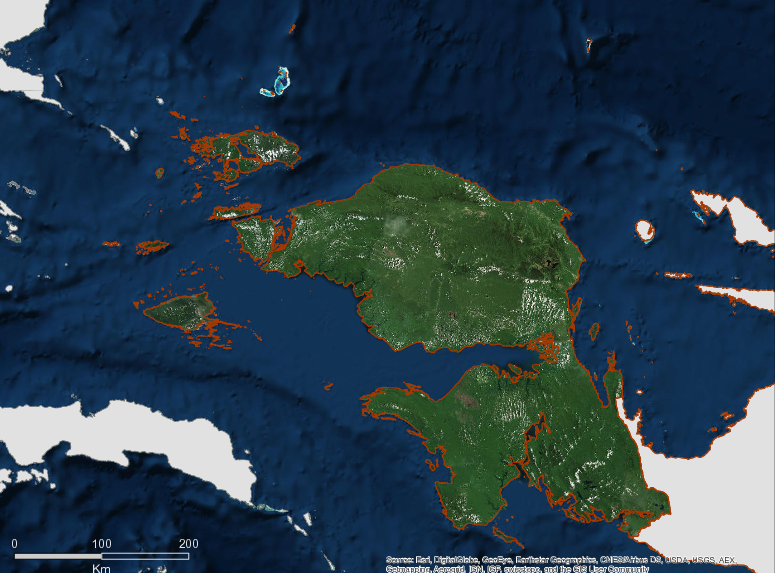
Description
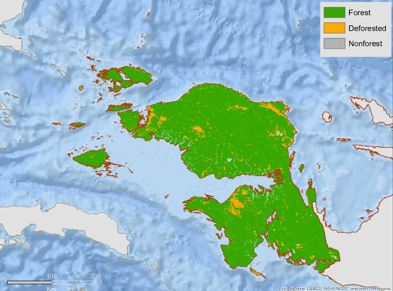
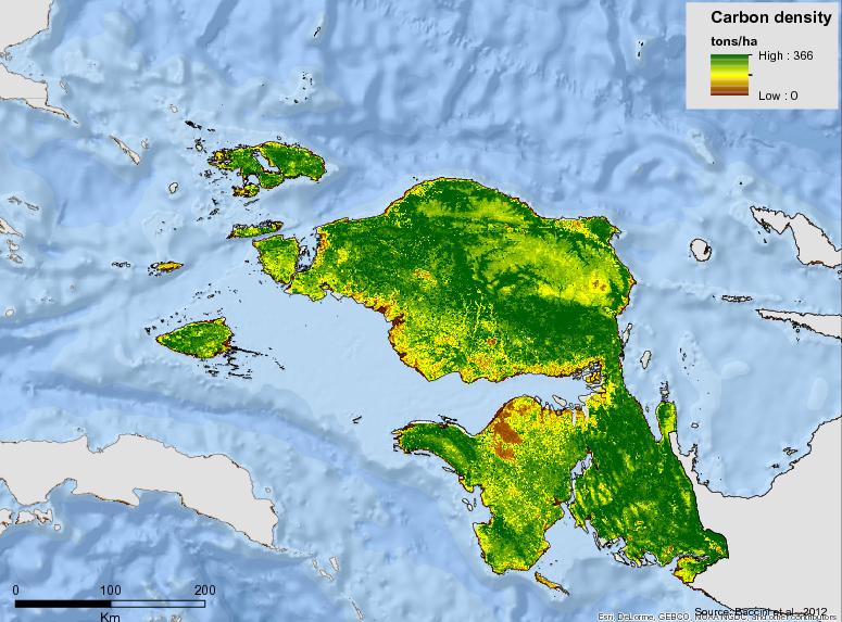
West Papua (Papua Barat) Covers the two western peninsulas of the island of New Guinea, West Papua is one of Indonesia’s two provinces located in the western part of the island of Papua. The capital is Manokwari, but the largest city is Sorong. The 2010 census recorded a population of 893,362 for the whole province. The total area of the province is approximately 10.0 million hectares, of which 9 million hectares are forest and 1 million hectares are peatland. With forest covering 90% of the total area of the province, West Papua has some of the most pristine primary forests in Indonesia. Plantation and crop area is minimal relative to primary and secondary upland and swamp forest. Over the course of 5 years (2006-2011), degradation rates reached nearly 600 thousand hectares. The deforestation and degradation rate is exceptionally low compared with other Indonesian provinces. The calculation of above ground carbon stock in 2009 amounted to 1,514.79 million tons and was conducted using the Tier-1 methodology based on the IPCC.
The province has tremendous potential, be it agriculture, mining, forest products and tourism. Pearls and seaweed are produced in Raja Ampat district while the only traditional weaving industry called Timor cloth is produced in Sorong Selatan district. Pure fragrant nutmeg can be obtained in Fak-Fak district. In addition, nature tourism is also one of the mainstays of West Papua, such as Cenderawasih Bay National Park located in Teluk Wondama district. After decades of top-down government management of forestry operations, with little consultation with affected communities, many indigenous communities in Papua and West Papua are far from clear about their rights to land and natural resources. 80% of the indigenous communities are in rural areas and 70% of these are officially classified as poor, with little access to information on government plans for their natural resources.
At the Green Governors Gala COP 13 (2007) in Bali, in front of the world’s political and business leaders, The Governors of Papua and West Papua expressed their support for reducing emissions from deforestation and forest degradation, or REDD+. The strategic issues raised in the SRAP document (Provincial Strategy and Action Plan) include (1) Increasing and aligning provincial conservation policies; (2) Accelerating establishment and operation of forest management units (KPH); (3) Addressing uncertainty of customary community rights; (4) Implementation of a community-based forest management paradigm; and (5) The policy of limiting the sale of logs to outside West Papua. The objectives of the implementation of the REDD+ Strategy and Action Plan in West Papua Province are (1) Reduce degradation and deforestation due to conversion of forest land and forest area functions; (2) Increase efforts to rehabilitate degraded land and development of community plantations; and (3) Improve forest and land governance and management through the implementation of development of Forest Management Units (KPH).
More information can be found on the GCF Impact Platform.
Summary
Demographics
Urban vs. Rural Population
| Category | % | |
|---|---|---|
| Rural | 74.70 | |
| Urban | 25.30 |
Ethnic Groups
| Group | % | |
|---|---|---|
| Other | 18.60 | |
| Javanese | 14.76 | |
| Arfak | 9.18 | |
| Biak-Numfor | 7.47 | |
| Ayfat | 6.06 | |
| Buginese | 5.32 | |
| Ambonese | 4.37 | |
| Butonese | 4.13 | |
| Baham | 2.94 | |
| Yapen | 2.49 | |
| Mooi | 2.40 | |
| Makassarese | 2.26 | |
| Kei/Evav | 2.20 | |
| Tehit | 2.12 | |
| Toraja | 1.81 | |
| Wandamen | 1.79 | |
| Minahasa | 1.79 | |
| Irahutu | 1.57 | |
| Kokoda | 1.33 | |
| Seram | 1.26 | |
| Inanwatan | 1.18 | |
| Wamesa | 1.16 | |
| Flores | 1.00 | |
| Sundanese | 0.95 | |
| Batak | 0.95 | |
| Ternate | 0.90 |
Economy
GDP Breakdown
| Category | % | |
|---|---|---|
| Processing Industry | 28.76 | |
| Mining & Quarrying | 19.49 | |
| Construction | 13.95 | |
| Agriculture, Livestock, Forestry & Fisheries | 10.82 | |
| Trade, Hotel & Restaurant | 6.73 | |
| Services | 4.83 | |
| Transport & Communication | 4.12 |
Forest Status
Major Vegetation Types
| Category | km² | |
|---|---|---|
| Primary Dry Forest | 48,607 | |
| Secondary Dryland Forests | 28,335 | |
| Primary Swamp Forest | 6,657 | |
| Shrubs | 3,951 | |
| Primary Mangrove Forest | 3,637 | |
| Savannah | 1,596 | |
| Secondary Mangrove Forest | 1,156 | |
| Crops | 998 | |
| Secondary Swamp Forest | 870 | |
| Plantation | 568 |
Forest Management
| Category | km² | |
|---|---|---|
| Conservation Areas | 26,397 | |
| Production Forest | 21,861 | |
| Limited Production Forest | 17,774 | |
| Protected forest | 16,277 | |
| Conversion Production Forest | 14,727 |
Drivers of Deforestation
- Mining
- Plantations
- Infrastructure development
- Illegal logging and logging concession activity
Deforestation Rates
Notes
| a. | Due to different methodological approaches and base years, Forest Status data fields may differ slightly. Data sources for each field are listed below. |
Sources
| 1. | Papua Barat Dalam Angka 2015 |
| 2. | Papua Barat Dalam Angka 2012, hal. 88, BPS Papua Barat |
| 3. | BPS 2016 |
| 4. | BPS – Statistics Indonesia , 2016 |
| 5. | West Papua in Number 2015, West Papua Statistic Central Bureau |
| 6. | Central Statistic Bureau, Analyzed from SUSENAS 2011-2013 |
| 7. | Official Statistic Announcement, West Papua Central Statistic Bureau |
| 8. | Potret Keadaan Hutan Indonesia 2000-2009 oleh Forest Watch Indonesia |
| 9. | Ministry of Environment and Forestry 2018 |
Overview of Forest Monitoring and Measurement Systems
At the national level, Indonesia’s National Forest Monitoring System (http://nfms.dephut.go.id/) is a platform which contains information about land cover, deforestation, potential forest resources and fire hotspots. This platform was developed as part of Indonesia’s commitment under the UNFCCC.
At the provincial level, the monitoring system for forest degradation—to be developed by the Forest Management Unit—has not yet been developed.
Reference Levels and Targets
Deforestation Rates
Sources
| 1. | STRATEGI DAN RENCANA AKSI PROVINSI (SRAP) PAPUA BARAT DALAM IMPLEMENTASI REDD+, halaman 5 |
| 2. | Rio Branco Declaration, based on National FREL |
| 3. | Ministry of Environment and Forestry 2018 |
Laws, Policies & Strategies
Overview
In 2014, the previous Governor Abraham Ataruri signed the Rio Branco Declaration (RBD). The signatories of the Rio Branco Declaration committed to reduce deforestation by 80% by 2020 if they received adequate, sufficient, and long-term performance-based funding. In 2016, Indonesia members have put together a work plan to implement declaration, including West Papua. West Papua Province has invited public and private investments to support the development of forest management units in the province.
In 2015, West Papua declared its commitment to becoming a conservation province. Since then, a draft of the Special Autonomy Law has been formulated. The draft is currently being finalized in the parliament. There have been some criticisms regarding the process of announcing the declaration of a conservation province considering that most land in West Papua is owned by indigenous people. Hence, from a social perspective, without a proper consultation process with indigenous groups, this could be seen as being similar to commercial land grabbing. However, if done properly, this commitment can present a significant opportunity for West Papua to define its own, unique development pathway that differs from other provinces that have experienced massive deforestation and degradation.
Currently, West Papua aims to build on Constitutional Court Decision No. 35/PUU-X/2012 that recognized the land rights of indigenous people in state forest areas. A draft Special Autonomy Law on the acknowledgement and protection the indigenous people rights on land has been drafted. The draft is currently under discussion in the provincial parliament. This regulation is fundamental for the recognition of indigenous land claims and should be signed into law before any large-scale land use activities, such as plantation estates or conservation activities, should be allowed in West Papua.
Efforts for developing and monitoring jurisdictional sustainability indicators have also been initiated. The project is financed by European Forestry Institute. The indicators were initially developed through a public consultation process at the provincial level, which should be further improved through more stakeholder consultations. A monitoring system to track the sustainability indicators is under development.
Strategies and Policies
West Papua Provincial REDD+ Action Plan (SRAP) – Published in April 2013, the REDD+ Action Plan highlights the general condition and issues of forestry, vision, mission, issues, implementation strategies, specific basis, accomplishment measurements, monitoring, reference emission level, and mitigation actions.
Local Action Plan for Greenhouse Gases Emission Reduction (RAD-GRK) – Completed in 2011, the RAD-GRK provides a medium term action plan for reducing greenhouse gas emissions across sectors in West Papua through 2020. The Projected Business as Usual (BAU) of West Papua Province by 2020 without mitigation action intervention, the forestry sector occupies the largest share of GHG emissions by 98%. The strategy was formalized in 2012 through governor decree. Chapters of the RAD-GRK are available for individual download: Chapter 1
Chapter 2
Chapter 3
Chapter 4Chapter 5
Chapter 6
Chapter 7
Laws and Regulations:
Draft Regulation on Customary Forests 2016 – Draft regulation on customary rights in the province of W Papua.
Provincial Regulation 15/2013 – Regarding Waste Management has been a strong push for the province to commence proper waste management to prevent pollution in major residential areas in the province.
Governor Regulation 12/2013– Regarding Timber Circulation – West Papua originally banned transporting raw logs to promote downstream timber industry through the issuance of Governor Regulation 2/2008. However, the ban caused problems with the production and sale of legal timber due to weak downstream industry. The issuance of Governor Regulation 12/2013 to revise Governor Regulation 2/2008 aims to prepare the downstream timber industry so the ban could be put in place in near future.
Provincial Regulation 11/2013 – Regarding the Protection of Women and Children from Violence provides a strong basis for developing policies, programs and activities to acknowledge and protect the right of women and children in the province.
Provincial Regulation 4/2013 – Formalizes the Provincial Spatial Plan of West Papua 2013-2033. The plan was revised in 2015 and the total protected forest area in the spatial plan decreased by 1.9 million hectares, from 5.3 million hectares to 3.3 million hectares. In the revised plan, this area is devoted to agriculture and other cultivation uses.
Governor Decree 674/98/III/2012 – establishes of coordination team to implement provincial action plan on GHG reduction to coordinate, socialization, facilitate, and monitoring of the related activities.
Special Autonomy Law 21/2001 – West Papua Province, which was established in 2003, enjoys the special autonomy status based on Law 21/2001. The Law was first issued for the entire Papua island, before it was split into two provinces, Papua and West Papua Provinces. The special autonomy status grants the authority for West Papua Province to manage the province, including the environment and natural resources, according to the local situations in the province. Specifically, the Law stipulates the authority of the provincial government to pursue economic development considering the sustainability of natural resources, respecting the rights of indigenous people, and ensuring the social protection of people in the province. Furthermore, the Law also stipulates the establishment of Indigenous People Council (Majelis Rakyat Papua) which represent the indigenous people groups in the decision-making process. The Law was further detailed into several provincial special autonomy laws, including Special Autonomy Laws 5/2010 on the selection of the Indigenous People Council representatives and 6/2012 regarding the authority of the Council.
Institutional Framework
Provincial Forestry Agency – manages and oversees the forestry sector related issues, including policy formulation.
Plantation Agency – controls the non-forest areas land use, plan, and issuance of the permits.
Environmental Agency – has authority over the protection and management of the environment, including climate change related issues.
BAPPEDA – the Provincial Development Planning Agency that coordinates on the policy formulation of the regional development planning with sustainable development and low carbon as the basis
Zoning & Spatial Planning
West Papua’s Spatial Plan was formalized through the provincial bylaw 4/2013 and covers the period 2013-2033. The Spatial Plan was revised in 2015, reducing the protected areas by 1.9 million hectares to 3.3 million hectares and increasing areas designated for cultivation.
Engagement & Participation with Indigenous Peoples and Local Communities
The People’s Assembly of West Papua represents indigenous Papuans and has certain powers for protecting the rights of indigenous Papuans based on respect for traditional customs and culture, as well as for women’s empowerment and the establishment of religious harmony in West Papua Province. West Papua Regional Law 4/2012 specifies how the Assembly’s membership is constituted.
Further, West Papua aims to take advantage of the constitutional court decision 35/2012 on land right acknowledgement. A draft Special Autonomous Law acknowledging and protecting indigenous peoples’ land rights has been developed. The indigenous/customary forest (Adat forest) plan represents a form of recognition of customary rights for forest areas and their forest resources.
Partnerships and Ongoing Initiatives
— Unnamed Initiative —
- Description
-
DGM Indonesia focuses on supporting activities related to the certainty of rights to land and natural resources as well as community-based and sustainable management. In addition, this funding can also be used to explore options for tenure instruments that take advantage of opportunities provided by the government (including the capacity building of indigenous peoples and local communities in carrying out selected options). In addition to the above activities, funding support for activities related to improving the livelihoods of indigenous peoples and local communities is also open to support selected tenure security options. To guarantee the participation and community ownership of the activities carried out, DGM Indonesia requires grantees to disseminate information, disseminate information to the community, FPIC or the like before implementing the project.
- Partners
- AMAN, Papua Institute for Indigenous Peoples Strengthening Studies (LSPK); Papua Arrow Association;, Limited Association for the Study and Empowerment of Indigenous Peoples (PtPPMA), LBBT Consortium
- Initiative Type
- indigenous peoples initiative
- Initiative Status
- Implementation
‘Green Economic Growth Programme for Papua Provinces’ (GEGPP)
- Description
-
The project was designed for Papua Province, although some activities will also be carried out in West Papua Province. Five technical work streams of the projects are:
-
Market Systems Analysis – to identify, define and pilot test the changes to market systems which are needed, in order to enable wide scale adoption of sustainable crop farming systems and land use practices (and thus improved climate resilience).
-
Socio-economic Planning and Gender Analysis – address the chronic capacity deficits that challenge rural Papuan SHFs and hamper their ability to compete with the agrarian trading/cultures of non-Papuan migrants, especially in more remote locations like the highlands.
-
Farming Methods and Production Systems – assist SHFs adopt sustainable crop systems and land use practices. The crops, value added products, and MSMEs selected and the supporting activities provided by the GEGPP team will be guided by a core set of internationally recognised sustainability principles.
-
Credit, Finance and Small Business Development – assist financial service providers become more active and build a portfolio of loans in the agriculture and agribusiness sector targeting indigenous Papuans.
-
Business Incubator and Investor Engagement – The GEGPP will help ensure improved access to business support services and investment funding to green growth oriented lead firms, ISPs and SMEs through a structured incubation and investment facilitation process.
-
- Partners
- UK Government
- Funding Amount
- £11 million
- Initiative Type
- Donor supported program
- Initiative Status
- Under implementation
Customary Right Acknowledgement
- Description
-
Currently, West Papua aims to build on Constitutional Court Decision No. 35/PUU-X/2012 that recognized the land rights of indigenous people in state forest areas. A draft Special Autonomy Law on the acknowledgement and protection the indigenous people rights on land has been drafted. The draft is currently under discussion in the provincial parliament. This regulation is fundamental for the recognition of indigenous land claims and should be signed into law before any large-scale land use activities, such as plantation estates or conservation activities, should be allowed in West Papua. No financial support is provided to the provincial government on the issue, except sporadic support provided by donors for civil society supporting the process.
- Partners
- Provincial Government, Indigenous People Council, Civil Society Organizations
- Initiative Type
- Technical Assistance Partnership
- Initiative Status
- Under implementation
Establishment of Production FMU with Indigenous Forest Community Model
- Description
-
Production FMU- Customary Forest Community model is the Production FMU that cooperates with indigenous peoples to operate the FMU Function. The model will be conducted in the Manokwari district and it aims to fulfill the needs of local wood in Manokwari city and nearby areas as well as improving the welfare of indigenous people who have customary rights in the Production FMU region.
- Initiative Type
- Technical Assistance Partnership, Indigenous Peoples Initiative
- Initiative Status
- In Discussion
Jurisdictional model of sustainable commodity production
- Description
-
Fakfak District Government in collaboration with INOBU, financed by Packard Foundation, IKI German and Norad, has initiated a jurisdictional model of sustainable commodity production as an alternative pathway of development for indigenous Papuans that does not depend on industrial-scale deforestation and plantation development, activities which are likely to disrupt customary land uses and livelihoods as well as the natural environment. The focus of sustainable commodity production in Fakfak is developing the potential of the local nutmeg industry. As part of the initiative, the multi-stakeholder working group (WG) on nutmeg, established in 2013, sets the milestones toward achieving sustainable production in Fakfak. The WG has begun mapping nutmeg farmers in the district; to date, more than 800 farmers’ plots have been mapped. Pilot villages have been selected for program interventions focused on teaching good agricultural practices as well as improving existing practices. The WG is also actively seeking and connecting global buyers of nutmeg and its derivatives with producers in Fakfak. The initiative sets out a model for prioritizing recognition of customary land and resource rights, followed by strengthening the management capacity of customary institutions while improving the markets and value for forest-maintaining community enterprise.
- Partners
- District Government of Fakfak; INOBU, AKAPE
- Initiative Type
- Technical Assistance Partnership
- Initiative Status
- Under implementation
Planting a Replacement Area of a Protected Forest Area
- Description
-
SKK-Migas and BP-Berau with indigenous peoples- customary owners will be planted with forest trees and versatile plant on degraded land of about 1320 Ha of protected forests of Bintuni Bay, Bintuni Bay that began in 2017 for 6 years up to 2022.
Currently, the process of structuring the plantation area is on-going.
- Partners
- SKK-Migas and BP Berau
- Funding Amount
- Rp.84.127.510.000.00 or 6 Million USD
- Initiative Type
- Private Investment
- Initiative Status
- Under Implementation
Planting a replacement área of a protected forest área – as a CSR
- Description
-
The partnership between SKK-Migas and BP-Berau companies and indigenous peoples will reforest 1.320 ha of protected forest area in Teluk Bintuni, using trees and other plants with multiple uses. The project began in 2017 and will run for 6 years, through 2022. Currently, planting in the area is on-going.
- Partners
- BP Berau; SKK Migas
- Initiative Type
- Finance provision initiative
- Initiative Status
- Under implementation