Campeche, Mexico
Mexico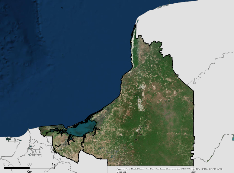
Description
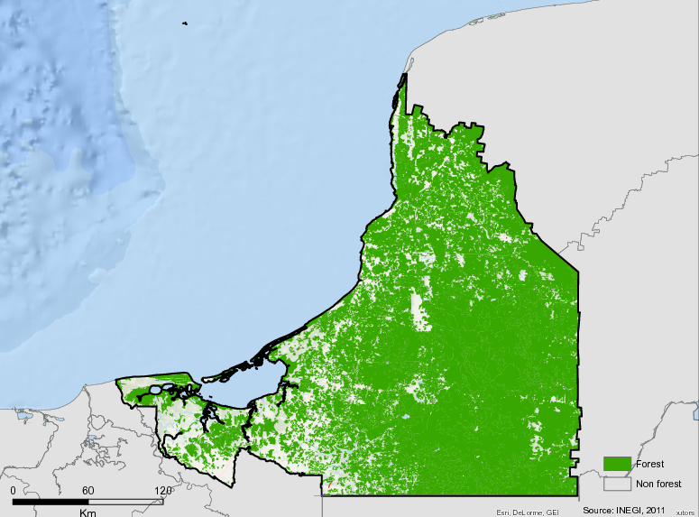
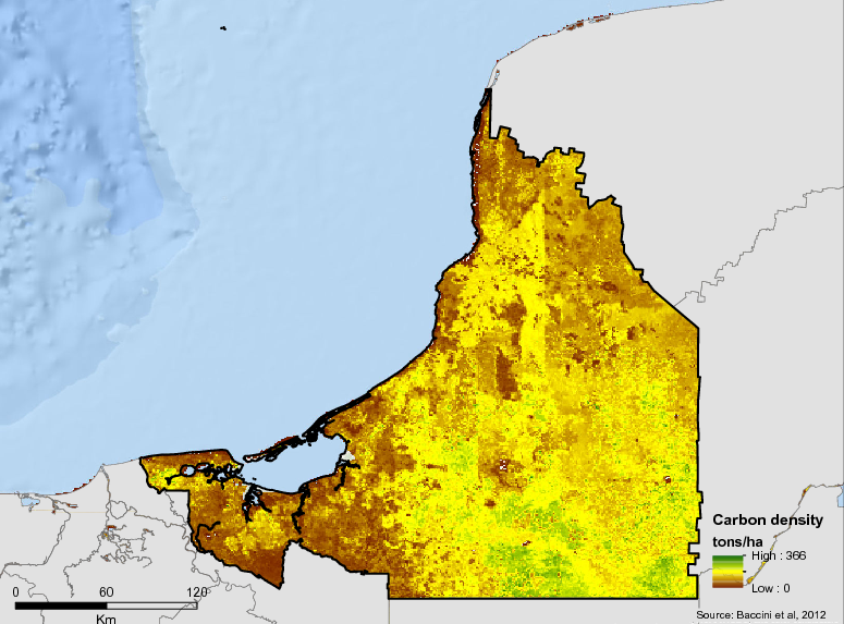
The territory of the state of Campeche has an area of 56,859 km2, of which 76.2% is still a mosaic of forests in relatively good condition. The state has the largest mangrove area (197,000 ha) in Mexico, equivalent to 30% of the national total. These forests and mangroves have the highest carbon storage capacity, greater than 100 MgCl / ha (Government of the State of Campeche, 2012b). Campeche has the largest protected area (2,278,765.59 ha) through Protected Natural Areas (ANP) in the Yucatan Peninsula, representing 40% of the state’s surface. The good state of conservation and connectivity of the states of Campeche, Yucatan and Quintana Roo, with the forests of Guatemala and Belize in Central America, make the forests of Campeche one of the survival areas of threatened and endangered species with special requirements such as felines (jaguar and puma), or ones that perform local “migrations” (such as birds or butterflies). Recent studies in Mexico infer that the forests of Campeche probably maintain the largest populations of species such as the jaguar (Panthera onca), the tapir (Tapirus bairdii), the white-lipped peccary (Tayassu pecari), the howler monkey (Alouatta spp), the spider monkey (Ateles geoffroyi), the elegant eagle (Spizaetus ornatus), the king vulture (Sarcoramphus papa), the ocellated turkey (Meleagris ocellata ) and snout (Craxrubra) (Government of the State of Campeche, 2012b).
Most of the territory of Campeche is characterized by a subhumid climate and a dense tropical forest. There is also a lowland region with lakes and rivers. The “milpa” system, which predominates in the state, requires a deep understanding of specific ecological systems, including the cycles of several plants and the rain cycle, as well as the fallow period required by their soils. Hunting and gathering are complementary subsistence activities. Local natural resources are used as materials to build houses and for energy needs. Together, these activities, along with forestry and livestock activities, have had a devastating impact on tropical forests, and attempts are being made to reverse the impact through sustainable development programs focused on reforestation and wildlife management. The State of Campeche faces a great challenge in the face of the potential effects of climate change and the phenomena of deforestation and forest degradation. The preservation policy has led to the creation of several protected areas, including the Calakmul Biosphere Reserve, notable for the number of indigenous migrants living within the 723,185 hectares of forest in the reserve and also for plans to develop opportunities for Ecological and archaeological tourism.
More information can be fond on the GCF Impact Platform.
Summary
Demographics
Urban vs. Rural Population
| Category | % | |
|---|---|---|
| Urban | 74.60 | |
| Rural | 25.40 |
Ethnic Groups
| Group | % | |
|---|---|---|
| Maya | 77.00 | |
| Chol | 10.00 | |
| Other | 7.00 | |
| Tzeltal | 2.00 | |
| Kanjobal | 1.80 | |
| Mame | 1.10 |
Economy
GDP Breakdown
| Category | % | |
|---|---|---|
| Industry, Mining | 81.80 | |
| Services | 17.10 | |
| Agriculture, Forestry | 1.10 |
Forest Status
Major Vegetation Types
| Category | km² | |
|---|---|---|
| Primary Perrenial | 25,691 | |
| Secondary Sub-deciduous Forest | 7,759 | |
| Primary Deciduous | 2,439 | |
| Secondary Perennial Forest | 2,384 | |
| Secondary Sub-deciduous Jungle | 800 | |
| Secondary Deciduous | 346 | |
| Secondary Encino Forest | 8 |
Forest Management
| Category | km² | |
|---|---|---|
| Ejido | 28,391 | |
| Protected Area | 19,403 |
Drivers of Deforestation
Deforestation is mainly driven by conversion to pasture land and to a lesser extent by agricultural land. A lack of forestry related economic activities is an indirect driver of deforestation.
Deforestation Rates
Notes
| a. | Due to different methodological approaches and base years, Forest Status data fields may differ slightly. Data sources for each field are listed below. |
Sources
| 1. | INEGI. Censo de Población y Vivienda 2010. Panorama sociodemográfico de Campeche. 2011. link |
| 2. | Mexico FREL link |
| 3. | INEGI, 2013. Volumen y crecimiento. Población total por entidad federativa, 1895 a 2010 link |
| 4. | INEGI, 2014. Perspectiva estadística Campeche link |
| 5. | EPRI, 2012. Overview of Subnational Programs to Reduce Emissions from Deforestation and Forest Degradation (REDD) as Part of the Governors’ Climate and Forests Task Force, Palo Alto. |
| 6. | Anuario estadístico. Campeche, Edición: 2012, Cobertura temporal: 2011 Desglose geográfico: Municipal, ISSN: 0188-8587 Formato: Electrónico link |
| 7. | Anuario estadístico. Campeche, Edición: 2012, Cobertura temporal: 2011 |
| 8. | calculated using values derived from INEGI, 2013, link |
| 9. | PNUD. El índice de desarrollo humano en México: cambios metodológicos e información para las entidades federativas. 2012 link |
| 10. | INEGI.Perspectiva Estadística. Serie por Entidad Federativa. México. link |
| 11. | Mexico FREL link |
| 12. | CONAFOR 2014 |
| 13. | INEGI/FCPF FREL |
| 14. | ERPD annexes |
| 15. | http://osse.org.mx/Recursos/Investigaciones/Estad%C3%ADsticas/Propiedad-Social/Ejidos |
Overview of Forest Monitoring and Measurement Systems
Since 2011, with funding from the Norwegian government and since 2013 under the MREDD + project with funds from the USA, Mexico has developed a forest monitoring and measurement system for REDD+. The system uses information from the National Forest and Soil Inventory (NFYS) and activity data generated with Madmex (Monitoring Activity Data for the Mexican REDD + program ). The purpose of the latter is to provide the possibility of processing the large amounts of data involved in a reasonable amount of time. A joint strategy is being facilitated so that Mexico, through CONAFOR, can generate MRV reports with an institutionalized and implemented system in the cloud, with wide availability to support decision-making in federal institutions and federal and state secretaries.
The National REDD+ Strategy of Mexico (ENAREDD+) points out that reference levels and the Monitoring and Verification Monitoring System (MRV) at the state and national levels should be carried out in a coordinated and integrated manner through the National MRV System; This is achieved through participation in the process of REDD + states in Mexico, including Campeche, to implement technical collaboration schemes and information exchange to improve databases and methodologies for use at the state level.
REDD+ Strategy of the State of Campeche (EREDD+ CAM ) incorporates within the monitoring, reporting and verification component (MRV), a monitoring system that allows measuring the potential risk of displacement, as well as ensuring the nesting of the state REDD+ MRV system with national systems and registers.
For its part, the Investment Program (PDI) of Campeche within the IRE, considers displacement as one of the risks to mitigate through measures according to the cause of deforestation / degradation. The community territorial ordinances (OTC) are an important part to address the identified risks.
During the process of preparation of REDD + in Mexico, the Government of the State of Campeche has participated with a group of entities in a process of capacity building with CONAFOR, for the subject of MRV between the Federation and the States, in order to identify gaps in subnational capacities.
CONAFOR and the Government of the State of Campeche published the State Forest and Soil Inventory of Campeche in 2015, and Campeche, along with Quintana Roo and Yucatán, promote a platform for monitoring and an early warning system in the Yucatan Peninsula, the Observatory of the Selva Maya (OSM), which considers measuring risks by reversion and displacement of emissions, linked to fires and productive activities, among other issues.
Reference Levels and Targets
Deforestation Rates
Sources
| 1. | Rio Branco Declaration based on National FREL |
| 2. | INEGI/FCPF FREL |
Laws, Policies & Strategies
Strategies and Policies
Regional Strategy for Adapting to Climate Change – This is a guiding tool and generator for regional synergies for adaptation, which are based on the binding commitments that each of the states has within their attributions and which are reflected in the state programs.
Yucatan Peninsula REDD + Regional Strategy – The regional vision of the REDD + initiative for the Yucatan Peninsula is structured through consultation, diagnosis and strategic planning activities which include the key players for the sustainable territorial development of the region.
Investment Program of the State of Campeche– This identifies productive practices and natural resource management that promote sustainable rural development and increase the economic and social value of forests and natural resources to deal with deforestation and forest degradation in the municipalities of Campeche, Champotón and Hopelchén.
Ecological Management Program of the Territory of the Municipalities of the State of Campeche – Analyzes deterioration trends and the potential use of natural resources, regulates/ induces the use of land and productive activities using environmental criteria, as well as works to achieve the protection of the environment through preservation and sustainable use of natural resources.
Laws and Regulations
Decree 182, 12/08/2012 Wildlife Law of the State of Campeche – Establishes standards for the protection and conservation of wildlife habitat, in accordance with the General Wildlife Law.
Decree 271, 02/10/2009 Creation of the State Forest Commission Law- Establishes the general guidelines for the conservation, protection and sustainable management of forests in Campeche by establishing the State Forest Commission and the State Forest State Program.
Decree 145, 03/07/2008 State Law on Sustainable Forest Development – Serves to regulate and promote the conservation, protection, restoration, management and use of forest resources. It also establishes the state forest inventory; and provides provisions for the organization and training of farmers and the promotion of the investments necessary to promote sustainable forest development in the State of Campeche.
Agricultural Law of the State of Campeche– This law is for public order and general observance. It aims to promote agricultural activities and sustainable development in order to increase efficiency, productivity and competitiveness through a environmentally concious use of natural resources, promote the organization of agricultural producers, and promote their full integration of the state’s productive process.
Law of Rights, Culture and Organization of the Indigenous Peoples and Communities of the State of Campeche-This law is for public order and social interest. The object being recognition, preservation and defense of the rights, culture and organization of indigenous peoples and communities settled in the State of Campeche. It also aims to establish the obligations of State Powers and municipal authorities in relation to their relationship with indigenous peoples and communities, to raise the social welfare of its members, and to promote their development through specific plans, programs and actions.
Law of Sustainable Forest Development for the State of Campeche– This law is for public order and interest and general observance throughout the State of Campeche. It aims to regulate and promote conservation, protection, restoration, management, management and utilization of forest ecosystems, organization and training of producers, commercialization. Additionally, it aims to promote investments necessary to promote sustainable forest development.
Law of Environmental Education of the State-This law is for public order and social interest and aims to incorporate environmental education for sustainable development on all levels, modalities and educational systems in the State of Campeche.
Law Creating the State Forest Commission- This law is for public order and general observance throughout the State of Campeche. The law aims to establish general guidelines for conservation, protection, restoration, production, management and sustainable use of forest ecosystems.
Internal Regulations of the Human Rights Commission of the State of Campeche-This law regulates the structure, powers and functioning of the Human Rights Commission of the State of Campeche as an autonomous management, budgetary entity, and legal personality. In charge of its own assets and the protection, observance, promotion, study and dissemination of human rights provided by the Mexican legal order.
Internal Rules of the Commission for Integral Development and Social Justice for the Mayan People and Other Indigenous Peoples Settled in the State of Campeche- This law regulates the structure and functioning of the Commission for Integral Development and Social Justice for the Mayan and other Indigenous Peoples Settled in the State of Campeche. It is obligatory that it is observed and integrated by civil servants in the indicated terms. The terms can be revised and modified according to the terms adopted in the meetings of committee members.
Institutional Framework
Ministry of Environment and Natural Resources of Campeche (SEMARNATCAM)- Promotes sustainable development and promotes the protection, restoration and conservation of natural resources.Responsible for implementing REDD+.Responsible for forest management, fire control, management of protected areas and indigenous territories, forest monitoring / deforestation. SEMARNATCAM also has an administrative area called the Environmental Protection Agency of Campeche, which is responsible for the protection of environmental resources in terms of inspection and surveillance.
Rural Development Secretariat of Campeche (SDR)– Supervises activities in the agricultural sector and promotes sustainable rural development
Federal Attorney’s Office of Environmental Protection (PROFEPA)– Supervises the application of the General Law of Ecological Balance and Environmental Protection.
Intersecretarial Commission on Climate Change of the State of Campeche – This body represents the institutional governance of climate change in which the state dependencies are represented and chaired by the Governor of the State of Campeche. It was installed in 2010 and reinstalled in 2017 to delineate strategies and policies in the State.
Sectoral Subcommittee on Environment and Natural Resources of the State of Campeche – This body is derived from the Planning Committee of the State of Campeche chaired by the Governor of the State.Represents the space of participation of the different actors that interact in the environmental sector such as municipal governments, federal government, academic institutions, research centers,civil, social and cooperative organizations.It meets at least 3 times a year and allows linking all the efforts of the sector through initiatives, strategies and programs to goals.It is also related to the Sectoral Subcommittee on Rural Development.
Technical Advisory Council (CTC) of REDD + for the State of Campeche – The CTC allows the integration of producers and representatives of the social base and the civil organization including academic sectors, civil associations and NGOs, and consults the projects and programs in the design and construction of the State REDD+ Strategy of Campeche.
The CTC designed a State Council on REDD+, which will boost efforts in Campeche to build the State’s REDD+ Strategy and Vision, and strengthen programs and actions promoted by government authorities, including the Coffee Agenda and the White Agenda of The Economic and Regional Governments Forest Sector Committee, formed within the Planning Committee for the Development of the State of Campeche (COPLADECAM), the highest state planning body.
State Forestry Council – This body of consultation and opinion allows the different actors related to the production, protection, conservation and use of forest resources to be linked to the REDD+ issue, given that in the year 2017 a committee was formed within said Council, in order to address the REDD+ issue and the Emissions Reduction Initiative (IRE) of Mexico in Campeche.This way, it included in its internal regulations, an attribution to be able to issue recommendations on the matter.
Zoning & Spatial Planning
In Campeche ecological zoning (Ordenamiento Ecológico) is an environmental policy tool used to regulate land use, protect the environment, and preserve the sustainable use of natural resources. Zoning is carried out at the municipal level, with plans completed for Calakmul, Campeche, Escárcega, Hopelchén, and Champoton.
Engagement & Participation with Indigenous Peoples and Local Communities
In Campeche, work has been carried out from the beginning for inclusion of local communities and indigenous people in planning of the strategies. Participatory workshops were held during 2011 and 2012 to create the regional REDD+ strategy. Then, the planning work of the REDD+ state strategy was inititated, for which a Technical Advisory Council was formed, which includes representatives of the local and indigenous communities.
Also, Campeche together with Quintana Roo and Yucatán have created a regional committee on social and environmental safeguards, in which both officials and organized groups were trained in this framework. This Regional Committee created in September 2016, serves as liaison with state CTCs, who are represented by members in the Regional Committee, which ensures the participation of technical specialists and representatives of society.
In the same way, Campeche as one of the 5 Mexican states included in the Emissions Reduction Initiative (IRE) as a program to reduce emissions before the World Bank, presented their technical document for the State REDD+ Safeguards Plan as one of the elements of the National Safeguards System and the Safeguards Information System. This document was presented to the World Bank at the end of 2017. It contains all of the laws, statutes, norms, policy instruments, dependencies, meetings and agreements in the matter related to REDD and Climate Change applied to respect and address social and environmental safeguards.
Partnerships and Ongoing Initiatives
— Unnamed Initiative —
- Description
-
The Association is made up of the State Secretaries of the Environment and the State Environmental Attorneys. Campeche currently chairs the organization and represents the entities in front of the Federal Government including SEMARNAT and other environmental agencies in Mexico.
- Partners
- Secretaries of the Environment and State Environmental Attorneys
- Funding Source
- ANAAE’s own funds and managed by the National Government
- Initiative Type
- Government Partnership
- Initiative Status
- Active for 15 years; Board changes every 2 years
ASPY: Business declaration for the Sustainability of the Yucatan Peninsula.
- Description
-
It is a voluntary declaration signed in December 2016, which emanates from the desire of the companies to move towards a responsible operation with the environment and the communities, to the extent of their areas of action, as a support to the fulfillment of the goals set in the ASPY signed by governments. In this Declaration, the signatory companies agree with the importance of “diminishing and reversing the loss of forests and jungles, promoting the sustainable use of biodiversity, while increasing the productivity and profitability of primary activities […] as well as a balanced development of secondary and tertiary activities “. On November 29, he makes his second annual progress report in Campeche.
- Partners
- Private companies of the Yucatan Peninsula
- Initiative Type
- Private Partnership
- Initiative Status
- In action
CATIE capacity building agreement
- Description
-
The purpose of the agreement is to create a framework of technical collaboration, research and capacity building between the government and the research center, to jointly carry out activities that allow maximum development in the training and specialization of human resources; joint investigations; technological development; information exchange; as well as technical or academic advice and publications in the related fields of interest among the signatories. By the end of 2018, your signature will be finalized and will come into force.
- Partners
- CATIE, SEMARNATCAM
- Initiative Type
- Public Private Partnership
- Initiative Status
- In action
Climate Change Fund of the Yucatan Peninsula
- Description
-
The Climate Fund of the Yucatan Peninsula was established in 2016 in association with the three Autonomous Universities of Campeche, Quintana Roo and Yucatán. State governments participate as members of the fund’s Advisory Council, which has the mission of supporting regional initiatives to mitigate and adapt to climate change by financing regional climate priorities. It will also seek to be a regional counterpart in the REDD + payment scheme of the FCPF Carbon Fund, in coordination with CONAFOR. This fund began operating in December 2016, in phase 1, developing the executive plan to implement the trust, coordinating the operational strategy of the Advisory Board, designing the fundraising plan and the procedures manual. This Fund is a trust that can capture and distribute resources at the regional and state level, so that it can receive private and international resources for the development of climate policy actions
- Partners
- The Nature Conservancy and the state governments of Quintana Roo, Campeche and Yucatán, Autonomous Universities of Campeche, Quintana Roo and Yucatán
- Funding Amount
- USD $ 400,000.00
- Initiative Type
- Financial initiative
- Initiative Status
- In action
Leadership Group of Subnational Governments for Meeting the Aichi Biodiversity Targets
- Description
-
Within the framework of the Conference of the Parties of the Convention on Biodiversity (COP13) held in December 2016 in Cancun, Quintana Roo, the Campeche Secretary of Environment and Natural Resources of Campeche (SEMARNATCAM) in coordination with the National Commission for Knowledge and Use of Biodiversity (CONABIO) and Local Governments for Sustainability (ICLEI) co – organized the 5th Global Biodiversity Summit of Cities and subnational governments. As a result of the meeting, leaders of subnational governments established an intative to build a new cooperative approach to exchange experiences and best practices, and established a plan of action for participating governments to meet the Aichi Biodiversity Targets.
- Partners
- Aichi, Japan; Catalonia, Spain; Ontario and Quebec in Canada; and Sao Paulo, Brazil
- Initiative Type
- Government Partnership
- Initiative Status
- Development of the 2017-2018 Action Plan
MOU Under2
- Description
-
The Under2 coalition is a global community of ambitious subnational governments publicly committed to deep long-term decarbonisation and supporting the climate goal of the Paris Agreement to limit the global average temperature rise well below 2˚C.
The coalition joins the signatories of the Under2 MOU, a public commitment by governments to reduce their greenhouse gas (GHG) emissions by 80% to 95% compared to 1990 levels, or 2 metric tons per capita per year carbon dioxide equivalent, by the year 2050. The Under2 Coalition is an initiative driven primarily by state, regional and provincial governments. However, jurisdictions at all levels of government can sign or endorse the Under2 MOU and thereby assume a commitment to carry out deep decarbonization in their jurisdictions. In Mexico, more than 15 states are part of the Coalition.
- Partners
- Government of the State of Campeche.
- Initiative Type
- Public Private Partnership
- Initiative Status
- Developing
Network of Regional Governments for Sustainable Development (NRG4SD)
- Description
-
Esta red incluye varias plataformas de participación en las que Campeche participa: la plataforma de biodiversidad de las regiones (R4BLP), la iniciativa de cambio climático, el grupo técnico de Aichi GoLS. Cada año se realiza una renovación de membresías y se refrendan en la asamblea general anual, tiene un Secretariado que vincula los diferentes programas y plataformas a las que accede. En esta red se interactúa además con agencias de cooperación, oficinas y órganos de las convenciones de las Naciones Unidas como UNEP, CBD, entre otras.
- Partners
- Miembros de regiones, gobiernos subnacionales y provincias de diversos países del mundo que interactúan en temas de cambio climático, biodiversidad y sustentabilidad.
- Initiative Type
- Government Partnership
- Initiative Status
- Work Plan and Action Plan in a General Assembly
Project Biodiversity and Sustainable Agrosilvopastoral Livestock Landscapes – BIOPASOS (SAGARPA – CONABIO – SDR – CATIE)
- Description
-
The objective is to strengthen the capacities of target audiences to conserve biodiversity and ecosystem services; create an institutional and policy framework that allows the promotion of agrosilvopastoral practices that improve productivity, quality of family life and reduce climate vulnerability in livestock landscapes of the states of Campeche, Chiapas and Jalisco. Led by CATIE, IICA, SDR, and the Technological Institute of Chiná, its objective is to work on the integration of agrosilvopastoral systems in livestock landscapes in localities of interest in the municipalities of Champotón, Escárcega and Calakmul.
To achieve this, the project will implement an intervention model based on the implementation of agrosilvopastoral systems and good livestock practices. The intervention will be carried out at different levels and scales, all necessary for the conservation of biodiversity.
In addition, BioPaSOS will generate information that will make informed and timely decisions for the design of public policy instruments that integrate elements of sustainability, reduction of climate effects and that will facilitate exploring the options available for the marketing of differentiated products, thereby contributing to strengthen the participation of the livestock sector in value chains. This strengthening also includes the promotion of partnerships with actors from the private sector, academia and other partners.
- Partners
- SDR State Government – Tropical Agricultural Research and Higher Education Center (CATIE) – Inter-American Institute for Cooperation on Agriculture (IICA)
- Initiative Type
- Public Private Partnership
- Initiative Status
- In action
Regional Safeguards Committee
- Description
-
The Safeguards Committee of the Yucatan Peninsula was formally installed on September 12, 2016, as a one-of-a-kind social participation platform, for specializing in giving feedback and providing inputs on the approach and respect of REDD + safeguards from a perspective regional.
The Committee is composed of representatives of communities, producer organizations, indigenous groups, civil society organizations, academia, and government agencies of the three levels of government.
Among its main functions, it contributes to the feedback of the national processes for the construction of the National Safeguards System (SNS) and the Safeguard Information System (SIS), collaborating closely with the National Forestry Commission (CONAFOR) and its delegations in the Yucatan Peninsula. Likewise, it provides support to the States of the Yucatan Peninsula in the feedback of the REDD + State Strategies and public policies associated with the approach and respect of the REDD + safeguards. Seeking to issue recommendations through bodies such as the Regional Commission on Climate Change of the Yucatan Peninsula, responsible for coordinating efforts and resources to undertake regional initiatives for mitigation and adaptation to climate change.
- Partners
- OSC, representatives of the academy of the three States of the Yucatan Peninsula, representatives of the, the state governments of Quintana Roo, Campeche and Yucatán, The Nature Conservancy,
- Initiative Type
- Public Private Partnership
- Initiative Status
- In action
State Plan on Safegurads (Plan Estatal de Salvaguardas – PES) REDD+
- Description
-
The state plan on safeguards (PES for its acronym in Spanish) is the operational instrument for environmental and social risk management through which Campeche, as one of the 5 Mexican states within the Emission Reduction Initiative (IRE) of the FCPF Carbon Fund, will promote the guidelines, mechanisms and procedures established in the World Bank Safeguards Framework to reduce and manage risks and enhance the benefits associated with REDD + activities that will be developed within Campeche’s Investment Programs for the IRE. The PES will have a validity of 5 years to coincide with the implementation of the IRE. Campeche prepared the draft of its Plan, which Mexico proposed to the World Bank in June 2017. After the validation, the final version of the PES of each of the 5 Mexican states will be integrated.
- Partners
- National Forestry Commision (CONAFOR)
- Initiative Type
- Indigenous Peoples initiative
- Initiative Status
- Planning stage (draft version complete)
Tumbira Letter: A Call to Action
- Description
-
The National Association of State Environmental Authorities (ANAAE), who chairs the Government of Campeche through the Secretariat of Environment and Natural Resources of Campeche (SEMARNATCAM) is promoting a new regional model of cooperation through the signing of the Charter of Tumbira: A Call to Action in May 2017, in the city of Manaus, Brazil.The purpose of the call is to strengthen cooperation between Latin American institutions in efforts to advance the Sustainable Development Goals. This model represents an example of leadership and teamwork to motivate and direct investment towards the strategic and responsible use of natural resources in Latin America.Outreach to additional members of the alliance, including from the private sector, has begun.
- Partners
- Governments and private sector leaders of Bolivia, Brazil, Mexico and Peru
- Initiative Type
- Public Private Partnership
- Initiative Status
- Planning phase (Charter signed in May 2017)
Yucatan Peninsula Climate Fund
- Description
-
The Yucatan Peninsula Climate Fund was established in 2016 in partnership with the three Autonomous Universities of Campeche, Quintana Roo and Yucatan.The state governments participate as members of the Advisory Council of the fund which has the mission of supporting regional intiatives to mitigate and adapt to climate change by funding regional climate priorities. It will also seek to be a regional counterpart in the REDD+ payment scheme of the FCPF Carbon Fund, in coordination with CONAFOR. This fund started operations in December 2016, in phase 1, developing the executive plan to implement the trust, coordinating the operational strategy of the Advisory Council, designing the fundraising plan and the procedures manual. This Fund is a trust that can capture and distribute resources in a regional and state way, so that it can receive private and international resources for the development of climate policy actions.
- Partners
- The Nature Conservancy, state governments of Quinatana Roo, Campeche and Yucatan, Autonomous Universities of Campeche, Quintana Roo and Yucatan
- Funding Source
- Private and International Funding including the FCPF Carbon Fund
- Initiative Type
- Financing Intiative
- Initiative Status
- Development of Executive Plan (first phase of implementation)
Yucatan Peninsula Framework Agreement on Sustainability for 2030 (ASPY 2030)
- Description
-
The ASPY strengthens collaboration among subnational governments to facilitate the transition and compliance with the Paris Agreement, the Bonn Challenge, the Rio Branco Declaration and the Aichi Targets, among others. The implementation of the ASPY 2030 will occur through the Regional Commission on Climate Change, formed through the first regional agreement on climate change signed at COP16 in 2010, and supported by initiatives of NGOs such as the Mayan Forestry Observatory that generate inputs for the forest policy.
The ASPY aims to conform through a transparent process, the Promotor Council of the Agreement for the Sustainability of the Yucatan Peninsula (ASPY 2030) as an advisory, interlocution and regional consultation body.
The agreement consists of 6 goals I. Achieve zero net deforestation in the year 2030 (with an interim step of reducing 80% – eighty percent – of gross deforestation by 2020). II. Restore two million terrestrial hectares, including: a. Sustainable intensification of agricultural production in 250,000 hectares in agricultural lands. b. Sustainable intensification of livestock in 250,000 hectares in agricultural land. c. Reforestation and restoration actions of degraded forests in 420,100 hectares. III. Achieve that 50% of the land and coastal territory of the Yucatan Peninsula is under conservation and / or forest management schemes. IV. Promote Mayan biocultural landscapes, in at least 5,484,000 hectares. V. Attract resources from private and / or international sources that represent the equivalent of the investment of public resources currently allocated to activities that promote the green economy and seek its progressive increase. SAW. Restore 20% of the reef crests (54 km) and 30% of the beach systems – coastal dunes altered by human settlements (80 km) that protect human communities, beaches and infrastructure
And it contemplates 8 components of implementation: I. Sustainable agricultural development II. Effective management of jungles III. Conservation of ecosystems IV. Water and ecosystems V. Sustainable management of coastal zones VI. Sustainable fishing VII. Promotion of green and responsible markets. VIII. Sustainable tourism
ASPY also has the support of a Declaration of the Private and Financial Sector, in which 70 companies of great impact in the region have expressed their interest in contributing to social and environmental responsibility with corporate sustainability, which will strongly contribute to the achievement of the objectives of the Agreement of Governors of the Yucatan Peninsula, ASPY 2030.
- Partners
- The Nature Conservancy and the state governments of Quintana Roo, Campeche and Yucatán, Autonomous Universities of Campeche, Quintana Roo and Yucatán
- Initiative Type
- Public Private Partnership
- Initiative Status
- Insubstantiated by sentence of a federal collegiate court
Yucatan Peninsula Framework Agreement on Sustainability for 2030 (ASPY 2030)
- Description
-
At COP 13 of the Conventions on Biodiversity held in Cancun in 2016, Quintana Roo, the Governments of the Yucatan Peninsula signed a collaborative work plan for 2030 called “Agreement for Sustainability of the Yucatan Peninsula” (ASPY 2030). This agreement strengthens collaboration among subnational governments to facilitate transition and compliance with the Paris Agreement, the Bonn Challenge, Rio Branco Declaration and the Aichi Goals among others. The implementation of the ASPY 2030 will occur through the Regional Climate Change Commission, formed through the first regional agreement on climate change signed at COP16 in 2010, and supported by NGO initiatives such as the Mayan Forest Observatory which generates inputs for forest policy. ASPY 2030 covers 8 components, each with specific lines of action:
- Sustainable agricultural development
- Effective forest management
- Ecosystem conservation
- Water and ecosystems
- Sustainable coastal management
- Sustainable fisheries
- Green and responsible market development
- Sustainable tourism
ASPY is also supported by a Declaration of the Private and Financial Sector, in which 70 companies of great impact in the region have expressed their interest in contributing social and environmental responsibility towards corporate sustainability, which will contribute strongly to achieving the goals of the Agreement of Governors of the Yucatan Peninsula, ASPY 2030. The Governors of ASPY 2030 are: Mr. Rolando Zapata Bello, Governor of Yucatan, Mexico; Lic. Carlos Joaquín González, Governor of Quintana Roo, Mexico and Lic. Rafael Alejandro Moreno Cárdenas, Governor of Campeche, Mexico.
- Partners
- State governments in collaboration with private sector actors, civil society and the federal government
- Initiative Type
- Public Private Partnership
- Initiative Status
- Development phase (implementation plan finalized in June 2017)