Quintana Roo, Mexico
Mexico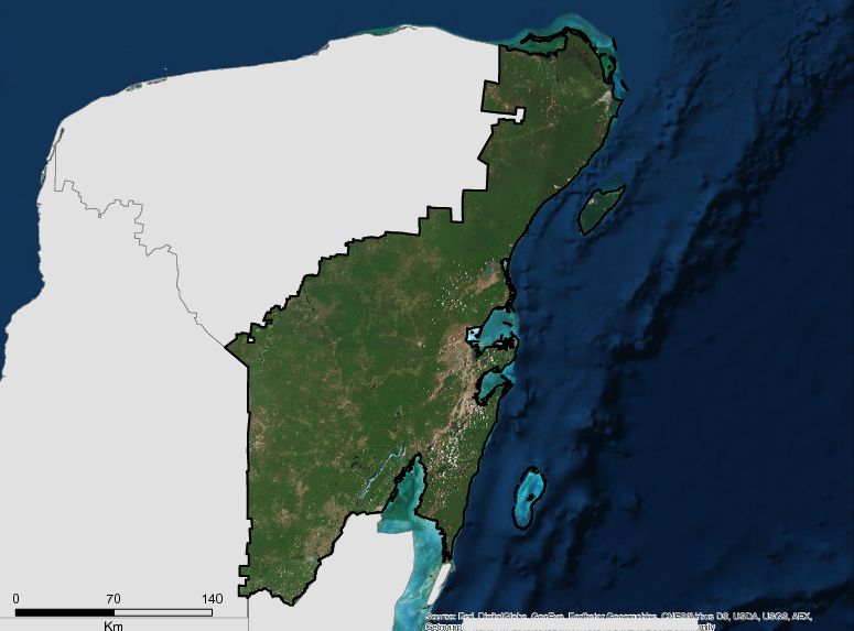
Description
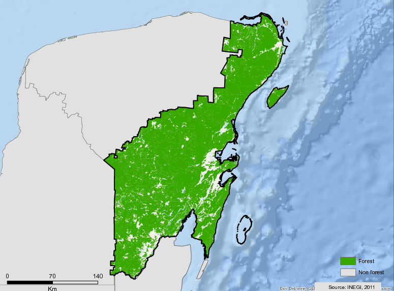
The state of Quintana Roo is located in the eastern part of the Mexican Republic, with its boundary to the east with the Caribbean Sea, to the north with the Gulf of Mexico and the state of Yucatan, to the west with the state of Campeche and to the south with Belize and Guatemala along a border of just over 180 km. The territory is approximately 5 million hectares occupying the 19th place in territorial extension in Mexico, although there is a territorial dispute with Campeche for just over 1/2 million hectares. The state has approximately 1000 km of coastline and 10 municipalities. Of the little more than 5 million hectares of state territory, around 4,160,000 hectares are currently covered by dense vegetation.
The three states of the Yucatan Peninsula (Campeche, Quintana Roo and Yucatán) share similar ecological and social characteristics, which allows us to analyze certain dynamics jointly. In the Yucatan Peninsula, most of the natural forest is tropical (mainly of medium height and lowlands, with very few areas of the mountain forest) and parts of this area are high meadows (secondary or replacement forest, which is part of a long rotation of the milpa farming system). Currently there are different estimates of the evaluation of deforestation rates due to the different forest definitions, methods, time periods studied and scales of analysis (Rueda, 2010). Most of the studies focus on the loss and partial recovery of forest cover, paying attention to the central and southern regions of the Peninsula (Turner et al., 2004; Bray and Klepeis, 2005; Vester et al., 2007; Ellis and Porter-Bolland, 2008), probably related to the fact that this part of the Peninsula is designated a biological corridor.
For the period from 1993 to 2002, the predominant process in Quintana Roo was the degradation of the perennial tropical forests. Quintana Roo registered a higher rate of degradation than deforestation. Between 2002 and 2007 there was a significant trend toward human settlements and infrastructure, which was an important factor in deforestation.
More information can be found in the Impact Platform of the GCF.
Summary
Demographics
Urban vs. Rural Population
| Category | % | |
|---|---|---|
| Urban | 88.00 | |
| Rural | 12.00 |
Ethnic Groups
| Group | % | |
|---|---|---|
| Other | 90.00 | |
| Maya | 0.10 | |
| Chol | 0.01 | |
| Kanjobal | 0.01 | |
| Tzotzil | 0.01 |
Economy
GDP Breakdown
| Category | % | |
|---|---|---|
| Services | 86.00 | |
| Industry, Mining | 13.00 | |
| Agriculture, Forestry | 1.00 |
Forest Status
Major Vegetation Types
| Category | km² | |
|---|---|---|
| Primary Perrenial | 28,839 | |
| Secondary Perennial Forest | 3,471 | |
| Secondary Sub-deciduous Forest | 2,587 | |
| Secondary Sub-deciduous Jungle | 230 | |
| Primary Deciduous | 43 |
Forest Management
| Category | km² | |
|---|---|---|
| Ejido | 27,942 | |
| Protected Area | 3,129 |
Drivers of Deforestation
- Extensive livestock farming with the use of induced and cultivated pastures;
- Mechanized agriculture;
- RTQ traditional agriculture;
- Poor application of forest management due to deficiencies in the organization and technical capacities;
- Jungles without plans and programs of forest management;
- Deficient capacity of the organizations in community rural development;
- Low profitability of the forestry activities in front of the agribusinesses; and
- Deficient institutional coordination in the alignment and application of public policies.
Deforestation Rates
Notes
| a. | Due to different methodological approaches and base years, Forest Status data fields may differ slightly. Data sources for each field are listed below. |
Sources
| 1. | Gobierno del Estado de Quintana Roo link |
| 2. | Mexico FREL link |
| 3. | Secretaría de Desarrollo Económico link |
| 4. | INEGI link |
| 5. | |
| 6. | Secretaría de Economía link |
| 7. | México ¿Cómo vamos? link |
| 8. | PNUD 2015 link |
| 9. | México, cómo vamos, Exportaciones Julio 2015 link |
| 10. | CONAFOR 2014 |
| 11. | INEGI/FCPF FREL |
| 12. |
Overview of Forest Monitoring and Measurement Systems
An MRV WG was formed in 2014, made up of entities from the three levels of government, academia and research centers, and civil society, with the purpose of combining efforts, capacities and resources to carry out various actions to monitor reporting and verification of GHG emissions and removals in the USCUSS / AFOLU sector to guide decision-making. In 2018 it is awaiting alignment with the national system, which is still waiting for the conformation of the reference levels. The State of Quintana ROO, through GT MRV, formulated lines of action to be implemented in the State derived from the diagnosis of subnational capacities.
Reference Levels and Targets
Deforestation Rates
Sources
| 1. | Rio Branco Declaration based on National FREL |
| 2. | INEGI/FCPF FREL |
Laws, Policies & Strategies
Strategies and Policies
State Climate Action Plan – The State Action Program on Climate Change of Quintana Roo (PEACCQROO) contains provisions to mitigate emissions and promote adaptation to the potential impacts of climate change. It establishes the framework for planning and implementing adaptation policies according to existing scientific knowledge. Included in the plan is a goal of achieving zero net deforestation and developing statewide programs to reduce deforestation.
FCPF Carbon Fund Investment Program – Quintana Roo has developed an investment program to reduce deforestation through the Mexico Emissions Reduction Initiative implemented under the framework of the Forest Carbon Partnership .
REDD + State Strategy (EEREDD +) – EEREDD + is a State planning instrument that identifies scenarios for reducing emissions from deforestation and forest degradation and contemplates actions to achieve such scenarios in a determined period where financing and forms of evaluation are defined. It has been constructed so that its guidelines guide public policies and programs according to their administrative responsibility, and encourage the development of activities in the field that achieve the reduction of emissions. In this way, the REDD + process will be guided in the State, in accordance with the national process.
The State Safeguards Plan – The State Safeguards Plan is an operational, flexible instrument that allows State governments to report to the Safeguards Information System (SIS) and demonstrate the way in which REDD + safeguards are addressed and respected in Mexico as well as other safeguard requirements for bilateral or multilateral initiatives. The Plan functions as a planning instrument for the implementation of measures to avoid and manage environmental and social risks and to enhance positive impacts in the implementation of REDD +. The Plan establishes mechanisms for coordination, implementation and monitoring of the application of safeguards related to the implementation of REDD + activities in the State, including the investment program of the IRE and the REDD + State Strategy.
Agreement for the Sustainability of the Yucatan Peninsula – The Agreement sets common goals and implements strategies in a coordinated way to achieve the sustainability of the Yucatan Peninsula, recognizing the value of biodiversity and the need for sustainable rural development so that communities and ecosystems can thrive.
Laws and Regulations
Decree No. 387 10/30/2015 Law of Ecological Balance and the Protection of the Environment – Promotes sustainable development, and regulates actions aimed at preservation and restoration of ecological balance, as well as protection of the environment of the State of Quintana Roo.
Decree No.19 2/27/2014 – Decree modifying the Local Ecological Ordinance Program of the Municipality of Benito Juárez.
Decree No. 116 6/16/2014 Forest Fire Law – Regulates the use of fire for agriculture, livestock and other purposes with an aim of reducing the impact of fire on forest resources.
Decree No. 269 4/30/2013 Climate Change Action Law – Formalizes the state plan for climate action and contains provisions to mitigate emissions and promote adaptation to the potential impacts of climate change. Establishes the framework to plan and implement adaptation policies in accordance with existing scientific knowledge. The plan includes the goal of achieving zero net deforestation and developing state programs to reduce deforestation.
Decree No. 306 8/19/2013 Forest Law – Establishes the regulatory framework for forest conservation, protection, restoration, production, management, crop management, and sustainable management of forest areas. Establishes innovative conservation measures including the “strategic forest reserves.” The revision in 2013 dissolved the state forestry institute and charges the Secretariat of Ecology and Environment of the state of Quintana Roo (SEMA) with the development and implementation of forestry policy.
Regulation of the Law of Ecological Equilibrium and Protection of the Environment of the State of Quintana Roo, in Matters of Environmental Impact 2011 – This instrument is generally observed in the areas where the State exercises its jurisdiction; Its purpose is to regulate the Law of Ecological Equilibrium and Environmental Protection of the State of Quintana Roo in terms of Environmental Impact.
Regulation of the Law of Ecological Balance and Environmental Protection of the State of Quintana Roo, in the Matter of Prevention and Control of Environmental Pollution – 2011. It applies throughout the State territory and the areas where the State exercises its sovereignty and jurisdiction, and its purpose is to regulate the Law of Ecological Equilibrium and Environmental Protection of the State of Quintana Roo, in the Matter of Prevention and Control of Environmental Pollution.
Law for the Prevention and Integrated Management of Residues of the State of Quintana Roo 2010 – Its purpose is to regulate and establish the provisions that promote strict compliance with the Law for the Prevention and Comprehensive Management of Residues of the State of Quintana Roo and governs throughout the territory of the State of Quintana Roo.
Decree No. 42 5/25/2009 – Decree by which the Local Ecological Ordering of the Municipality of Solidarity is established.
Decree No. 102 10/21/2008 – Decree of the Local Ecological Management Program of the Municipality of Cozumel. Subsequently modified in December 2011.
Decree of the Local Ecological Management Program of the Municipality of Isla Mujeres, Quintana Roo 2008 – Published in the 2008 Newspaper.
Territorial Ecological Management Program of the Costa Maya Region, Quintana Roo 2006 – Published in the Official Newspaper 2006.
Program of Territorial Ecological Regulation of the Region of Laguna de Bacalar, Quintana Roo 2005 – Published in the Official Newspaper 2005.
Ecological Management Program of the Coastal Zone of the Sian Kaan Biosphere Reserve 2002 – Decreed in the Official Newspaper 2002.
Ecological Territorial Ordering Program of the Region Denominated Cancun-Tulum Corridor. Decreed in 2001.
Institutional Framework
Secretariat of Ecology and Environment of the State of Quintana Roo (SEMA)’s mission is to incorporate in all areas of society the criteria and instruments that ensure an ecological culture that prioritizes the care of the environment and preservation of the environment, when making decisions to encourage and promote the sustainable use of natural resources, consolidating a green Quintana Roo, and promoting new forms of participation that encourage the citizen individually and in organized groups to intervene in the formulation and execution of public environmental policies. It also strengthens public environmental management in the state, considering the variable of climate change, with its mitigation and adaptation aspects.
Secretariat of Agricultural, Rural and Fishing Development of the State of Quintana Roo’s mission is to promote agricultural and rural development, through the planning, execution of policies and sustainable sector programs, and to promote the integral development of the rural communities of the state of Quintana Roo.
Secretariat of Finance and Planning (SEFIPLAN) of the Government of the State of Quintana Roo is responsible for promoting the formulation of proposals for bills, regulations and other provisions regarding planning, programming, budgetary policy, information, evaluation, institutional coordination and regional development, social development and assistance to marginal groups.
REDD working group (GT REDD +) is formed by representatives of the municipal, state and federal governmental institutions linked to the REDD issue.
Zoning & Spatial Planning
Ecological Zoning has been completed in 8 municipalities of Quintana Roo, with seven of the eight plans incorporating climate change into the spatial planning considerations.
Engagement & Participation with Indigenous Peoples and Local Communities
Safeguards are understood as principles, conditions or social and environmental criteria that guide the design and implementation of policies, programs and other actions. The purpose of the safeguards is to prevent and mitigate any direct and indirect negative impact on the ecosystems and the population, particularly, on the communities and indigenous peoples that inhabit them, including their rights in the face of risk or damage scenarios derived from the actions to reduce emissions from deforestation and degradation. One of the aspects to consider in the definition and application of the safeguards is the respect of the Free, Prior and Informed Consent of the rural and indigenous communities.
Free, Prior and Informed Consent is a framework that aims to ensure that the rights of indigenous peoples are guaranteed in any decision that may affect their lands, territories or livelihoods. The consultation and the obtainment of the FPIC must be carried out from the stage of definition of the projects and / or whenever there are anticipated legislative or administrative measures susceptible to directly affect the communities and indigenous peoples of Quintana Roo.
The safeguards seek to generate the necessary conditions for the adequate implementation, monitoring, reporting and evaluation of REDD + safeguards in the state of Quintana Roo, in correspondence with international commitments and the guidelines established at the national level, particularly in relation to the National Safeguards System (SNS) and the REDD + Safeguards Information System (SIS).
With the following lines of action:
- Creation of a Committee on State Safeguards.
- The REDD + State CTC, since it is an advocacy space in the REDD + policy, could include the members of the REDD + State Safeguards Committee as a technical group of safeguards. Likewise, the Committee can be part of the regional REDD + CTC.
- Establish an Observatory of Social and Environmental Safeguards of the Yucatan Peninsula, through the Observatory of the Selva Maya.
- Disseminate the principles and criteria that support social and environmental safeguards among the different actors.
- Identify and analyze the State institutions that would be responsible for guaranteeing compliance with the legal framework, relevant to safeguards.
- Manage the adequacy of state legislation in accordance with the needs defined in the legal diagnosis of this Strategy (sections 3.1 and 3.1.1.), in order to facilitate compliance with social and environmental safeguards in the State of Quintana Roo.
- Analyze the legal, institutional and state compliance framework in order to identify existing gaps that limit the observance of social and environmental safeguards, in accordance with the implementation of the line of action.
- Prepare complementary recommendations for the updating of the legal, institutional and compliance framework that propitiate an adequate implementation of the safeguards, as well as promote this update.
- Develop indicators at the state level that take as a basis the guidelines provided at the national (federal) level. The latter can be structural (those linked to the legal, institutional and compliance framework that support the effective application of safeguards), process (those that reflect the processes, mechanisms, and / or procedures that implement the safeguards) and results (those that reflect the results of the safeguards, in terms of benefits). The use of indicators specifically developed at the state level will help to ensure that the context of application of the safeguards at the sub-national level is met.
- Strengthen existing inter-institutional arrangements and promote those necessary to ensure respect for REDD + safeguards, as well as their inclusion in the relevant and applicable legal framework.
- Promote relevant institutional arrangements between federal and state orders, especially in the following areas: feedback, resolution of complaints and disputes, rendering of accounts and aspects of non-compliance with safeguards.
- Promote the design of a State Information System of Safeguards (SIES) in accordance with the guidelines and state and national institutional arrangements.
- Strengthen processes and institutional arrangements for the participation of relevant actors in the identification of risks, the implementation and follow-up of REDD + actions.
- Promote the active, informed and culturally appropriate participation of the social groups involved in REDD + actions, particularly indigenous peoples and communities and local communities.
- Promote specific measures to increase the active participation of women in the design, implementation, monitoring and evaluation of REDD + actions.
- Strengthen local and regional governance structures that foster collaborative actions for compliance with REDD + safeguards.
- Strengthen the capacities of the different bodies of state government and municipal governments in the matter of safeguards and their importance in the context of REDD + actions.
- Strengthen capacities for knowledge and exercise of the rights and obligations of forest owners related to REDD +, through relevant mechanisms and culturally appropriate means.
- Rethink if the REDD + CTCs are the appropriate platforms for the participation and consultation of indigenous peoples or, if necessary, generate new spaces, or modify existing ones.
- Establish the critical path to harmonize state legislation in a way that is consistent with social and environmental safeguards, in accordance with Goal X of this Strategy.
Some complications inherent to the application of the safeguards are presented, which are expected to be addressed as institutional arrangements advance both at the federal and state levels. Such is the case of consultations in ejidal assemblies: although the legal figure with the greatest weight in any ejido is the assembly, its access remains reserved exclusively for the ejidatarios and in no way can it be considered as a body representative of the interests of a population. For its part, the full and effective participation of indigenous and local communities is complicated in REDD + processes, because Article 1 of the Constitution defines indigenous peoples as “subjects of public interest” and not as “subjects of law”. This implies that indigenous peoples do not have legal personality to exercise their rights and submit to obligations, which could pose limitations for the implementation of free and informed prior consent (Ramos and Ludlow, 2015).
The actions contemplated in terms of social and environmental safeguards, must be developed under the planning framework of the State Safeguard Plans (PES). The State Safeguard Plans must establish mechanisms for coordination, implementation and monitoring of the application of the safeguards related to the implementation of REDD + in the states, including the investment programs (IP) of the Emissions Reduction Initiative (IRE). It is important to highlight that the PES are an integral part of the Articulation and functioning of the National Safeguards System (SNS), the Safeguards Information System (SIS) and the Environmental and Social Management Framework (MGAS) for REDD + in Mexico. A State Safeguards Plan is a state planning instrument that allows for the follow-up of the planning and review of the REDD + State Strategies (including territorial and programmatic actions) guaranteeing the approach and respect of REDD + safeguards in Mexico. It will be an operational instrument for the management of environmental and social risks focused on reporting information of state competence that will complement the different sources of information and report considered by the SIS. The general objective of the PES is the management of environmental and social risks, by addressing, avoiding and minimizing the risks of negative impacts as well as enhancing social and environmental benefits associated with REDD + activities that will be carried out in the state.
Partnerships and Ongoing Initiatives
Alliance of municipalities of the South of Quintana Roo (AMUSUR)
- Description
-
The governance of resources and territorial management are fundamental in regional development programs, in this area, important economic resources have been invested to have instruments for governance at the community level, but it is also necessary to consolidate inter-municipal structures to create a vision of development, considering as axis the existing natural resources in the regions. The Intermunicipal Association of the South of Quintana Roo (AMUSUR) conformed by the four municipalities of the South of the State, Othón P. Blanco, Bacalar, Felipe Carrillo Puerto and José María Morelos, is a great opportunity that must be strengthened and take advantage of the capacities of management and infrastructure with which count the municipalities and the alliance between them.
On June 5, 2013, in the Framework of the World Environment Day, the 4 Presidents signed the Creation Agreement, which was published on August 30 of the same year in the Official Newspaper, with the purpose of providing technical support to the Municipalities for the elaboration, management and implementation of the projects and programs related to the environment and management of the natural resources of application in their territories according to their faculties and attributions that the Municipalities have in the Federal and State Laws, contributing jointly to improve the living conditions of the local population, through an adequate management of the environment that sustains or increases the productive capacity of the natural resources of the south of the State of Quintana Roo.
On January 25, 2017, the AMUSUR was installed and the Governing Board was formed within the framework of the First Session of the AMUSUR and the Municipality of Othón P. Blanco was appointed as president. Each municipality will occupy the Presidency of the Board for a period of 9 months, completing the duration of the Municipal Administration.
- Partners
- City Councils of Othón P. Blanco,, José María Morelos, Felipe Carrillo Puerto and Bacalar., Government of the State of Quintana Roo
- Funding Amount
- $ 120,000.00 Each of the partner municipalities, must contribute $ 30,000.00 annually for the administrative operation of this agency.
- Initiative Type
- Decentralized Public Organization
- Initiative Status
- In action
ASPY: Business declaration for the Sustainability of the Yucatan Peninsula.
- Description
-
It is a voluntary declaration signed in December 2016, which emanates from the desire of the companies to move towards a responsible operation with the environment and the communities, to the extent of their areas of action, as a support to the fulfillment of the goals set in the ASPY signed by governments. In this Declaration, the signatory companies agree with the importance of “diminishing and reversing the loss of forests and jungles, promoting the sustainable use of biodiversity, while increasing the productivity and profitability of primary activities […] as well as a balanced development of secondary and tertiary activities “. On November 29, he makes his second annual progress report in Campeche.
- Partners
- Private companies of the Yucatan Peninsula
- Initiative Type
- Private Partnership
- Initiative Status
- In action
Climate Change Fund of the Yucatan Peninsula
- Description
-
The Climate Fund of the Yucatan Peninsula was established in 2016 in association with the three Autonomous Universities of Campeche, Quintana Roo and Yucatán. State governments participate as members of the fund’s Advisory Council, which has the mission of supporting regional initiatives to mitigate and adapt to climate change by financing regional climate priorities. It will also seek to be a regional counterpart in the REDD + payment scheme of the FCPF Carbon Fund, in coordination with CONAFOR. This fund began operating in December 2016, in phase 1, developing the executive plan to implement the trust, coordinating the operational strategy of the Advisory Board, designing the fundraising plan and the procedures manual. This Fund is a trust that can capture and distribute resources at the regional and state level, so that it can receive private and international resources for the development of climate policy actions
- Partners
- The Nature Conservancy and the state governments of Quintana Roo, Campeche and Yucatán, Autonomous Universities of Campeche, Quintana Roo and Yucatán
- Funding Amount
- USD $ 400,000.00
- Initiative Type
- Financial initiative
- Initiative Status
- In action
Future fund Climate group
- Description
-
The purpose of this future fund is to capture and channel public, private, national and international financial resources to support the implementation of adaptation and mitigation actions in the face of climate change in Quintana Roo.
- Partners
- Government of the State of Quintana Roo
- Initiative Type
- Financial initiative
- Initiative Status
- Developing
Investment program-IRE
- Description
-
IPs are instruments of long-term territorial planning, and constitute the
core component of the IRE. The IRE region in the state of Quintana Roo, which was specified and delimited in four of the eleven municipalities of the state; Felipe Carrillo Puerto, Othon P. Blanco, José María Morelos and Bacalar identified as the central and southern region of the state.
In order to achieve these objectives, it is important the participation of the agrarian nuclei, their holders, as well as their residents in the first instance, at another level they find the necessary participation of the government institutions influencing in a transversal and coordinated way, and finally the APDT ( Public Agents of Territorial Development), which will be the entity that facilitates and allows the synergy between the actions of government and the ejidos that make up the IRE.
- Partners
- Government of the State of Quintana Roo (SEDARPE), The Nature Conservancy The World Bank, CONABIO, CONAFOR, INAES (National Institute of the Social Economy) SAGARPA
- Funding Amount
- TOTAL: $ 671,386,500
- Initiative Type
- Public Private Partnership
- Initiative Status
- In action
Regional Safeguards Committee
- Description
-
The Safeguards Committee of the Yucatan Peninsula was formally installed on September 12, 2016, as a one-of-a-kind social participation platform, for specializing in giving feedback and providing inputs on the approach and respect of REDD + safeguards from a perspective regional.
The Committee is composed of representatives of communities, producer organizations, indigenous groups, civil society organizations, academia, and government agencies of the three levels of government.
Among its main functions, it contributes to the feedback of the national processes for the construction of the National Safeguards System (SNS) and the Safeguard Information System (SIS), collaborating closely with the National Forestry Commission (CONAFOR) and its delegations in the Yucatan Peninsula. Likewise, it provides support to the States of the Yucatan Peninsula in the feedback of the REDD + State Strategies and public policies associated with the approach and respect of the REDD + safeguards. Seeking to issue recommendations through bodies such as the Regional Commission on Climate Change of the Yucatan Peninsula, responsible for coordinating efforts and resources to undertake regional initiatives for mitigation and adaptation to climate change.
- Partners
- OSC, representatives of the academy of the three States of the Yucatan Peninsula, representatives of the, the state governments of Quintana Roo, Campeche and Yucatán, The Nature Conservancy,
- Initiative Type
- Public Private Partnership
- Initiative Status
- In action
Sustainable productive territories
- Description
-
This initiative is aimed at activating ecotourism and primary economic activities (pastoral management, the recovery of the Mayan milpa, timber products) for sustainable benefits of the recovery of the ecosystems of Quintana Roo. It is about promoting conservation with a human face of communities that protect and produce from the jungle.
- Partners
- SEMA SEDARPE CONAFOR, CONABIO, INAES
- Funding Amount
- $ 3,000,000.00
- Initiative Type
- Financial initiative
- Initiative Status
- In action
The New York Declaration on Forests
- Description
-
Food security for all can be improved at the same time in which the vision of diminishing, stopping and reversing the loss of forests globally is shared. Reducing emissions from deforestation and increasing forest restoration will be extremely important in limiting global warming by 2° C. In fact, forests represent one of the largest and most economically effective of the available climate solutions nowadays. Actions to conserve, sustainably manage and restore forests can contribute to economic growth, to poverty reduction, to the rule of law, to food security, to climate resilience and to the conservation of biodiversity. These actions can also help to ensure that the rights of indigenous peoples dependent on forests are respected, as well as to encourage their participation as well as that of local communities in decision-making. We commit to do our part to achieve the following results, acting in a collective alliance, including ensuring that there are strong and large-scale economic incentives that are commensurate with the size of the challenge:
- Reduce, at least by half, the rate of loss of natural forests worldwide by the year 2020 and make efforts to end the loss of natural forests by the year 2030;
- Support and help meet the private sector’s objective of eliminating deforestation caused by the exploitation of agricultural products, such as: palm oil, soybeans, paper and beef products; no later than 2020, recognizing that many companies have even more ambitious goals;
- Significantly reduce deforestation derived from the other sectors of the economy by the year 2020;
- Support alternatives to deforestation driven by basic needs such as subsistence agriculture and dependence on firewood for energy, in order to alleviate poverty and promote sustainable and equitable development;
- Restore 150 million hectares of degraded land and forest land by 2020 and significantly increase the rate of restoration, globally thereafter, that would restore at least another 200 million hectares by 2030;
- Include ambitious quantitative conservation and forest restoration objectives for the year 2030 within the post-2015 global development framework, as part of the new international objectives of sustainable development;
- To agree, in 2015, to reduce the emissions derived from deforestation and forest degradation as part of a post-2020 global climate agreement, in accordance with internationally agreed norms and consistent with the objective of not exceeding a 2 ° C increase in temperature; and
- Provide support for the development and implementation of strategies to reduce forest emissions.
This would strengthen forest governance, transparency and the rule of law; while empowering local communities and recognizing the rights of indigenous peoples, especially those related to their lands and resources.
- Partners
- State governments in collaboration with actors from the private sector, civil society and the federal government
- Initiative Type
- Public-private partnership
- Initiative Status
- It was ratified early in 2018.
Under2 MOU
- Description
-
The MOU was signed by this Government in 2015, whose objective is to limit global warming to less than 2° Celsius, which the scientists of the Intergovernmental Panel on Climate Change (IPCC) say is necessary to avoid dangerous consequences. The shared objective of the Under2 Coalition is to limit greenhouse gas emissions to 2 tons per capita, or 80-95% below the 1990 level by 2050.
- Partners
- The state governments of different countries in collaboration with actors from the private sector and civil society
- Initiative Type
- Public-private partnership
- Initiative Status
- Development phase
Yucatan Peninsula Climate Fund
- Description
-
The Yucatan Peninsula Climate Fund was established in 2016 in association with the three Autonomous Universities of Campeche, Quintana Roo and Yucatan. State governments participate as members of the fund’s Advisory Council which has the mission of supporting the regional initiative to mitigate and adapt to climate change by funding regional climate priorities. It will also seek to be a regional counterpart in the REDD+ payment scheme of the FCPF Carbon Fund, in coordination with CONAFOR. This fund started operations in December 2016, in phase 1, developing the executive plan to implement the trust, coordinating the operational strategy of the Advisory Council, and designing the fundraising plan and the procedures manual. This Fund is a trust that allows capturing and distributing regional and state so that it can receive private and international resources for the development of climate policy actions.
- Partners
- The Nature Conservancy, state governments of Quinatana Roo, Campeche and Yucatan, Autonomous Universities of Campeche, Quintana Roo and Yucatan
- Funding Source
- Private and International Funding including the FCPF Carbon Fund
- Initiative Type
- Financing Initiative
- Initiative Status
- Development of Executive Plan (first phase of implementation)
Yucatan Peninsula Framework Agreement on Sustainability for 2030 (ASPY 2030)
- Description
-
The ASPY strengthens collaboration among subnational governments to facilitate the transition and compliance with the Paris Agreement, the Bonn Challenge, the Rio Branco Declaration and the Aichi Targets, among others. The implementation of the ASPY 2030 will occur through the Regional Commission on Climate Change, formed through the first regional agreement on climate change signed at COP16 in 2010, and supported by initiatives of NGOs such as the Mayan Forestry Observatory that generate inputs for the forest policy.
The ASPY aims to conform through a transparent process, the Promotor Council of the Agreement for the Sustainability of the Yucatan Peninsula (ASPY 2030) as an advisory, interlocution and regional consultation body.
The agreement consists of 6 goals I. Achieve zero net deforestation in the year 2030 (with an interim step of reducing 80% – eighty percent – of gross deforestation by 2020). II. Restore two million terrestrial hectares, including: a. Sustainable intensification of agricultural production in 250,000 hectares in agricultural lands. b. Sustainable intensification of livestock in 250,000 hectares in agricultural land. c. Reforestation and restoration actions of degraded forests in 420,100 hectares. III. Achieve that 50% of the land and coastal territory of the Yucatan Peninsula is under conservation and / or forest management schemes. IV. Promote Mayan biocultural landscapes, in at least 5,484,000 hectares. V. Attract resources from private and / or international sources that represent the equivalent of the investment of public resources currently allocated to activities that promote the green economy and seek its progressive increase. SAW. Restore 20% of the reef crests (54 km) and 30% of the beach systems – coastal dunes altered by human settlements (80 km) that protect human communities, beaches and infrastructure
And it contemplates 8 components of implementation: I. Sustainable agricultural development II. Effective management of jungles III. Conservation of ecosystems IV. Water and ecosystems V. Sustainable management of coastal zones VI. Sustainable fishing VII. Promotion of green and responsible markets. VIII. Sustainable tourism
ASPY also has the support of a Declaration of the Private and Financial Sector, in which 70 companies of great impact in the region have expressed their interest in contributing to social and environmental responsibility with corporate sustainability, which will strongly contribute to the achievement of the objectives of the Agreement of Governors of the Yucatan Peninsula, ASPY 2030.
- Partners
- The Nature Conservancy and the state governments of Quintana Roo, Campeche and Yucatán, Autonomous Universities of Campeche, Quintana Roo and Yucatán
- Initiative Type
- Public Private Partnership
- Initiative Status
- Insubstantiated by sentence of a federal collegiate court
Yucatan Peninsula Framework Agreement on Sustainability for 2030 (ASPY 2030)
- Description
-
At COP 13 of the Conventions on Biodiversity held in Cancun in 2016, Quintana Roo and the Governments of the Yucatan Peninsula signed a collaborative work plan for 2030 called “Agreement for Sustainability of the Yucatan Peninsula” (ASPY 2030). This agreement strengthens collaboration among subnational governments to facilitate transition and compliance with the Paris Agreement, the Bonn Challenge, Rio Branco Declaration and the Aichi Targets, among others. The implementation of the ASPY 2030 will occur through the Regional Climate Change Commission, formed through the first regional agreement on climate change signed at COP16 in 2010, and supported by NGO initiatives such as the Mayan Forest Observatory which generate inputs for forest policy. ASPY 2030 covers 8 components, each with specific lines of action:
- sustainable agricultural development,
- effective forest management,
- ecosystem conservation,
- water and ecosystems,
- sustainable coastal management,
- sustainable fisheries,
- green and responsible market development, and
- sustainable tourism
ASPY is also supported by a Declaration of the Private and Financial Sector, in which 70 companies of great impact in the region have expressed their interest in contributing to social and environmental responsibility with corporate sustainability, which will contribute strongly to achieving the goals of the Agreement of Governors of the Yucatan Peninsula, ASPY 2030. The Governors of ASPY 2030 are: Mr. Rolando Zapata Bello, Governor of Yucatan, Mexico; Lic. Carlos Joaquín González, Governor of Quintana Roo, Mexico and Lic. Rafael Alejandro Moreno Cárdenas, Governor of Campeche, Mexico.
- Partners
- State governments in collaboration with private sector actors, civil society and the federal government
- Initiative Type
- Public Private Partnership
- Initiative Status
- Development phase (implementation plan finalized in June 2017)