Amazonas, Peru
Peru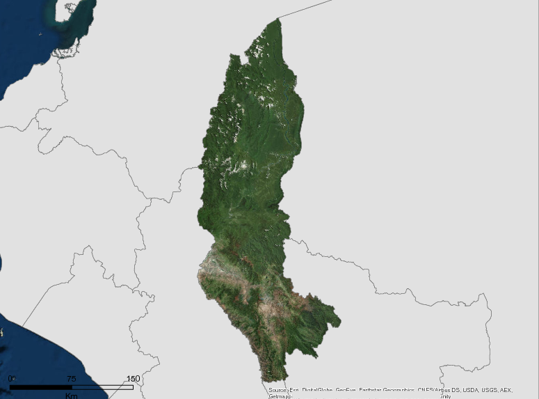
Description
While the region of Amazonas has historically low deforestation rates, it faces several challenges in forest management. The region hosts several native communities(including Awajun, Aguaruna and Wampis) that depend on timber and non-timber forest resources, as well as the provision of ecosystem services to maintain their livelihoods.
Amazonas has taken steps to improve the management of its forests by creating a Regional Environmental Authority through Regional Ordinance No. 327- REGIONAL GOVERNMENT AMZONAS / CR, dated 17 May 2013, and implementing a Regional Conservation System adopted by Regional Ordinance No. 235 – REGIONAL GOVERNMENT AMAZONAS / CR, dated 05 June 20 09. However, there are pending challenges such as the design of a forest conservation strategy at the regional level, as well as improving management for the sustainable use of forest resources (especially forests in native communities), and increasing external financing through international cooperation to support these initiatives.
Additional information can be found on the GCF Impact Platform.
Summary
Demographics
Urban vs. Rural Population
| Category | % | |
|---|---|---|
| Rural | 55.00 | |
| Urban | 45.00 |
Ethnic Groups
| Group | % | |
|---|---|---|
| Aguaruna (Aguajun) | 43896 | |
| Huambisa | 8257 |
Economy
GDP Breakdown
| Category | % | |
|---|---|---|
| Agriculture, Livestock, Hunting and Forestry | 32.03 | |
| Other sectors | 26.55 | |
| Other service sectors | 19.62 | |
| Commerce | 11.54 | |
| Building | 10.26 |
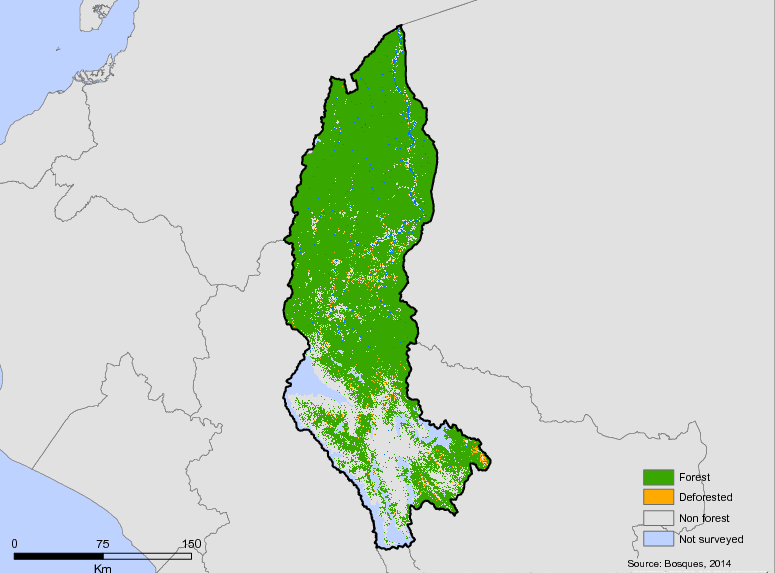
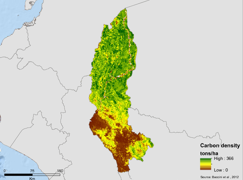
Forest Status
Major Vegetation Types
| Category | km² | |
|---|---|---|
| Intervening Areas | 11,240 | |
| Andean forests with medium and large trees in high mountains | 8,742 | |
| Forests with medium-sized trees of low mountains, eastern sub-Andean | 8,543 | |
| Others | 6,165 | |
| Sub-Andean forests of steep high mountains | 2,728 | |
| Sub-Andean forests with medium and large trees in low mountains | 2,450 | |
| Dense sub-Andean forests with large and medium trees in low hills | 2,182 |
Forest Management
| Category | km² | |
|---|---|---|
| Native titled communities | 14,678 | |
| National Protected Areas | 3,868 | |
| Private Conservation Areas - ACP | 1,072 | |
| Concessions for conservation | 529 | |
| Areas of Environmental Conservation - ACA | 261 |
Drivers of Deforestation
There are no official studies on the factors that drive deforestation in Amazonas. According to the monitoring project of the Peruvian Amazon, during 2017 in the district of Nieva- the area with the highest level of deforestation in Amazonas – it is pointed out that the cause of deforestation is agricultural activity.
Deforestation Rates
Notes
| a. | Due to different methodological approaches and base years, Forest Status data fields may differ slightly. Data sources for each field are listed below. |
Sources
| 1. | (INEI, 2016) link |
| 2. | (INEI, 2016) link |
| 3. | (INEI, 2016) link |
| 4. | (INEI, 2017) link |
| 5. | (BCRP, 2016) link |
| 6. | (PNUD-Perú, S/F) link |
| 7. | MINAM Geobosques, Information on forest cover in 2001 |
| 8. | (MINAM, 2016) link |
| 9. | Mapa de vegetacion del MINAM (2016) |
| 10. | Elaboracion propia basada en informacion proporcionada por el Gobierno Regional de Amazonas |
| 11. |
Overview of Forest Monitoring and Measurement Systems
Currently the Ministry of the Environment performs the monitoring of the forest cover and the levels of degradation, systematizing this information in its Geobosques platform. Amazonas works with the information provided by the national level.
Reference Levels and Targets
Deforestation Rates
Sources
| 1. | Rio Branco Declaration based on national FREL |
| 2. | (MINAM, 2016) link |
Laws, Policies & Strategies
Strategies and Policies
Amazonas Regional Climate Change Strategy (2017): Includes climate vulnerability, identifies sources of greenhouse gas emissions and proposes governance needed to carry out the strategy and corresponding Implementation Plan. Strategy is aligned with Peru National Climate Change Strategy and Ministry of Environment.
Regional Plan of Environmental Action 2014-2021– The plan is an instrument of long-term regional environmental planning, formulated from the regional environmental diagnosis and based on the axes of the National Environmental Policy: Conservation and sustainable use of resources and biological diversity, integral management of environmental quality, environmental governance and international environmental commitments and opportunities. Contains the strategic axes, objectives, indicators, actions, baseline of 2012, goals to 2017 and 2021, as well as the scope and responsible institutions. Each of these goals can be achieved through strategic actions and activities that will be carried out by the responsible entities and the society as a whole in the Regional and Local Government, which will be evaluated through environmental indicators, under the supervision of the Regional Environmental Authority.
Regional Environmental Policy
– This policy is an instrument of environmental management, prepared taking into account the analysis of the environmental situation of the Amazon region. It constitutes the basis for the conservation of the environment, in such a way as to promote and ensure the sustainable and responsible use of natural resources and the environment that sustains them, to contribute to the integral, social, economic and cultural development of people.
Strategic Plan for Concerted Development– This document includes an analysis of the region including its territory, the population, and the environmental and productive sectors.This document establishes the current situation and projects strategic objectives according to the 5 axes of the region that include the rights of people, access to services, environment and disaster risk, economy and employment, institutionality and governance.In addition, a 2021 target for the area of preserved forests of 2,842,100 hectares is established in the environmental component. In terms of GHG mitigation and climate change planning, there are 5 indicators that include the implementation of local governments in solid waste management, the implementation of wastewater management, the reduction of deforested area, the increase in works with a focus on reducing environmental impact and reducing vulnerability to disasters.
Laws and Regulations
Ordinance No. 00397/2017 – Approves the Regional Environmental Agenda for the period 2017-2018, with a focus on three topics: policy, conservation and sustainable use of natural resources and biodiversity, and integrated management and environmental governance.
Ordinance No.394-2017
– Declares the development and application of the Zoning and Forest Management process of regional interest, and forms the Technical Team to facilitate the development of Forest Zoning.
Ordinance No. 00366/2015– Ordinance updating the regional system of environmental management in the region of Amazonas
Ordinance No. 00366/2015 – Ordinance to update the regional environmental management system in the Amazon region
Ordinance No.365-2015
– Ordinance approving the Regional Environmental Agenda 2015-2016.This environmental agenda is aimed at the management and conservation of natural resources with a sustainable approach and adaptation to climate change.
Regulation of Organization and Functions – Regional Environment Authority 2015
– Defines the structure and responsibility of the Regional Environment Authority. It highlights the authority of the ARA in the implementation of policies, strategies, programs and plans in the field of territorial planning, sustainable management of natural resources, conservation of biodiversity and protection of the public environment.
Ordinance No. 00364/2014– Ordinance approving the regional plan of environmental action 2014-2020
Regional Ordinance 362/2014 – Institutionalizes the Community Platform for Forest Management of the Amazon Region (PMFC) as a space for dialogue, consensus and permanent promotion of the sustainable management of forests on the lands of native communities in the region.
Regional Ordinance No. 354/2014 – Ordinance approving the Regional Environmental Diagnosis 2012-2021 and the Amazonas Regional Environmental Policy
Ordinance No. 00327/2013– Ordinance formalizing the creation of regional environmental authority (ARA) and promulgating the regulation of the organization and its functions.
Ministerial Resolution 0696/2010
– Transfers forest management functions for the regional government of Amazonas.
Ordinance 223/2008
– Regional Strategy for Climate Change -The Amazon Climate Change Strategy highlights the need to control migratory agriculture and unplanned settlements and to develop and support institutions to control deforestation.
Ordinance No. 00023/2007
– Creates the Regional Environmental Information System – SIAR – of Amazonas, as the environmental management instrument, aimed at concentrating the environmental information of the Amazon Region
Institutional Framework
Regional Environmental Authority- In 2013, Regional Ordinance 327-2013- GRA / CR approves the creation of the Amazon Regional Environmental Authority “on environmental matters, territorial planning and sustainable management of natural resources” with its line organizers such as: The Executive Directorate of Natural Resources, the Executive Directorate of Environmental Management and the Executive Directorate of Forest and Wildlife Management . In addition, it approves and incorporates Administrative documents of the Regional Environmental Authority: the Organization and Functions Regulation and the Staff Assignment. As a complementary provision, the Ordinance also details that the composition of the Authority Regional Environmental comes from the merger of the Sub Management of Natural Resources and the Environment and the Forestry Directorate and of Wildlife.
Regional Agrarian Directorate –The Regional Agrarian Directorate through Management Regional Economic Development has a fundamental role in promoting agriculture not linked to deforestation expressed in its institutional mission: “promote development of agricultural producers organized in value chains or productive chains and contribute to improving the conditions of life of our rural inhabitants through activities of promotion, training and dissemination of statistical information agrarian and achieve sustainable agriculture both economically, social and environmental”.
Zoning & Spatial Planning
In 2010, the Economic Ecological Zoning of Amazon approved with the Regional Ordinance 200-2007-GRACR at a macrozoning level. This document analyzes the biophysical features of the Region, the current socioeconomic status, the potential and limitations of the territory and its natural resources, the zoning of the region and the recommendations for the formulation of policies and planning plans territorial in the region. The Amazon ZEE declares that 65.56 percent of the territory are protection and conservation zones ecological while 16.19 percent are productive zones. The study was developed at the level of macrozoning, using a work scale of 1: 250,000 and a publication scale of 1: 500,000.
Engagement & Participation with Indigenous Peoples and Local Communities
According to the Instituto de Bien Comun (2016), Amazonas has 54 farming communities, of which 2 are located in Bagua, 11 in Bongará, 23 in Chachapoyas, 17 in Luya and 1 in Utcubamba , of which 52 are recognized and titled remaining pending 1 in Utcubamba and 1 in Bongará . On the other hand, according to the Ministry of Culture (2012) there are 14,678 km2 associated with indigenous communities, representing 37.4% of the Amazonas territory and of which 171 native communities are titled.
For its part, the Regional Government has in its organization the Sub-office of Native and Peasant Communities under the structure of the Economic Development Management, whose purpose is to organize meetings and committees with district governments and representatives of local communities; as well as, the presentation of the regional proposal on the territories of these communities for their subsequent participatory implementation.
Partnerships and Ongoing Initiatives
Bosques Andinos Program – Phase 1 (considers Bolivia, Chile, Colombia, Ecuador, Peru, Venezuela and Argentina)
- Description
-
This project considers working with DGFEA-MINAM on the design of incentives for forest conservation and water harvesting based on previous experiences that provide evidence (such as water funds, MRSE, others). It also considers contributing to the sectoral goals of the government and the commitments of the country within the framework of the NDCs. Likewise, it considers promoting the national plan for the recovery of degraded areas and promoting the national forest plan to incorporate the zoning of Andean forests, as well as a pilot in Apurímac, as well as the prevention of forest fires through a prevention plan. There is no detailed information on the specific activities of this project for Amazonas.
- Partners
- SERFOR, HELVETASS, Swiss Intercoperation, CONDESAN
- Funding Amount
- CHF 6,900,000 (approximately USD 6,929,670) Total executed in Amazonas not specified.
- Initiative Type
- Project implemented by a consortium integrated by HELVETASS Swiss Intercooperation and CONDESAN
- Initiative Status
- In implementation (2014-2019)
Improvement of the environmental information service for the mapping of forest deforestation
- Description
-
The Project “Improvement of the environmental information service for the mapping of forest deforestation” is one of the four projects of the Forest Investment Program (FIP) approved for Peru. This Project seeks to strengthen the capacities of the Peruvian Government and key actors, such as indigenous peoples, to monitor deforestation. To this end, it proposes to articulate the georeferenced information systems, generate and distribute monitoring information, develop capacities to generate and distribute the information generated, the design of a community monitoring system as well as training and equipment for native communities. Specific activities for Amazonas will be defined in 2019.
- Partners
- Ministry of the Environment, Ministry of Economy and Finance, Inter-American Development Bank
- Funding Amount
- S / 39,930,000 for the entire Peruvian Amazon. Total for Amazonas not determined.
- Initiative Type
- Public investment project partially financed with resources from the CIF, operated by the IDB and deposited as a donation / loan to the Peruvian Government (60% donation / 40% loan in general for the entire program)
- Initiative Status
- At the start of execution (2018-2022)
Joint Declaration of Intent between the Governments of Peru, Norway and Germany (DCI) "Cooperation for the reduction of emissions of greenhouse gases from deforestation and forest degradation (REDD +) and to promote sustainable development in Peru"
- Description
-
The Joint Declaration of Intent (DCI) is a voluntary cooperation agreement signed by the Governments of Peru, Norway and Germany to achieve the reduction of greenhouse gas emissions produced by deforestation and forest degradation in Peru. It was signed in September 2014 with a validity until 2020 and considers actions for the conservation of forests in the Peruvian Amazon.
The JIU is based on a scheme of financial incentives on the progress and / or fulfillment of deliverables or goals divided into three phases: preparatory phase, transformation phase and payment by results phase. The phases of the JIU are directly related to the strategic actions of the National Strategy on Forests and Climate Change (ENBCC) and different planning instruments for development in Peru, such as: a) the Bicentennial Plan: Peru by 2021, b) The National Environmental Action Plan (PLANAA), c) the Agreed Regional Development Plans of the Amazonian regions in Peru, d) the National Strategy on Climate Change, e) National Strategy on Biological Diversity and its Plan of Action, f ) the National Forestry and Wildlife Policy, among other instruments.
The Phase II Implementation Plan defines in more detail what activities will be carried out in the Amazon Region. This document can be hired at: http://www.minam.gob.pe/cambioclimatico/wp-content/uploads/sites/127/2018/06/Plan-de-Implementación-Fase-II-DCI.pdf
- Partners
- Government of Peru, Government of the Kingdom of Norway Government of the Federal Republic of Germany
- Funding Amount
- Investment made so far at the national level USD6.5 M. Potential for cooperation: Up to USD240 million subject to progress in the goals of each phase and payment for results.
- Initiative Type
- Trilateral agreement between governments at the national level.
- Initiative Status
- In execution (Phase I and II)
National UN-REDD Peru Program
- Description
-
The UN-REDD National Program seeks to strengthen the strategic framework necessary for the implementation of REDD + and the ENBCC. Thus, it is expected to improve regional governance for the implementation of the ENBCC, NDC and REDD +, provide national or regional public institutions with instruments that facilitate the implementation of ENBCC, REDD + and NDC, develop public and private investment projects for the implementation of the policy, programs and measures prioritized in the framework of the ENBCC, to elaborate a proposal of reference level of forest emissions that integrate emissions data due to forest degradation, in addition to achieving that the indigenous approach is integrated in the module of forest cover and other SNIFFS modules in Peru, as appropriate. Specific activities for Ucayali will be defined in 2019.
- Partners
- Ministry of the Environment, UNDP, UNEP, FAO
- Funding Amount
- USD 4,065,779
- Initiative Type
- Project implemented through the national implementation modality (component under UNDP) and direct implementation (UNEP and FAO components)
- Initiative Status
- At the start of execution. Period December 2017-May 2020
Phase 3 of the Forests, Farms and Finance Initiative
- Description
-
Phase 3 of the Forests, Farms and Finance Initiative “Building bridges between local policies, REDD + and initiatives for sustainable supply chains” will support the construction of jurisdictional low emissions rural development plans.
In Peru, the 3FI initiative is led by the Earth Innovation Institute and the Amazon Regional Council (CIAM, in Spanish) and is developing incentives for low-emission rural development under a production and protection approach. The activities of 3FI in the Peruvian Amazon are led by the regional governments and are open to the participation of any public or private institution that wishes to contribute. 3FI considers with special attention the participation of indigenous peoples and women in the activities to be carried out. The initiative is based on empowering the progress of each region to make the necessary incentives proposals by building tailored instruments for each jurisdiction. Output from the project include: (a) developing regional plans or roadmaps to promote a transition to low-emission rural development; (b) promoting a transparent dialogue process at the regional level which includes the perspectives of indigenous peoples and women; and (c) developing a business plan to attract private investment and promote low-emission rural development in the Peruvian Amazon.
- Partners
- Earth Innovation Institute, CIAM
- Initiative Type
- Technical Assistance Partnership
- Initiative Status
- Under Implementation
Phase II of the Support to the Implementation of the National Strategy for the Reduction of Emissions for Avoided Deforestation and Forest Degradation in Peru "(RPP-2)
- Description
-
The RRP-2 Project 1.1. seeks to create the necessary conditions for the preparation and implementation stage of REDD + in Peru. This Project will consider strengthening spaces for citizen participation, such as the REDD + Indigenous Tables, the design of a grievance mechanism, implementing the PPIA, strengthening regional governments to implement the NDC and the ENBCC, and conducting studies for the effectiveness of strategies and land use planning instruments, contribute to the implementation of the national REDD registry, design benefit sharing mechanisms, improve the forest monitoring platform, update the forest reference level, design early response protocols to the monitoring reports of forests and implement a pilot of the Safeguards Information System. Specific activities for Amazonas will be defined in 2019.
- Partners
- Ministry of the Environment, FCPF, Ministry of Economy and Finance, Inter-American Development Bank
- Funding Amount
- USD 5,000,000.00 for all of Peru. Total for Amazonas not determined.
- Initiative Type
- Project that enters as a donation from the FCPF to the Peruvian Government through the IDB. Executed by MINAM (PNCB Executing Unit)
- Initiative Status
- At the start of execution
Preparing the way for the implementation of the Transformation Phase of the Joint Statement of Intent signed by the Governments of the Republic of Peru, the Kingdom of Norway and the Federal Republic of Germany
- Description
-
This project is considered as the first disbursement by the Norwegian Government to the Peruvian Government associated with the DCI. It considers four components or results: 1) the Government of Peru has planned the implementation of Phase II of the JIU and has begun its execution efficiently, 2) the zoning and forest management in the San Martin and Ucayali regions has increased, 3 ) value of the increased forest in order to be more competitive against the activities that cause deforestation and forest degradation, and 4) control of illegal activities that cause deforestation and forest degradation has increased. Activities for the Amazon Region included the participation of the Regional Government of Amazonas in the design of the Implementation Plan for Phase II of the JIU.
- Partners
- Ministry of the Environment, UNDP
- Funding Amount
- USD 6,135,722. Total executed in Amazonas not specified.
- Initiative Type
- Project executed through UNDP under the modality of national implementation
- Initiative Status
- In execution Period: June 2016-August 2018
Pro Amazonas
- Description
-
Pro Amazonas is an executing unit of the Amazonas Regional Government that allows the implementation of investment projects in an agile manner. It executes resources on tourism, road infrastructure and sanitation in Amazonas within the framework of an agreement with the Japan International Cooperation Agency. Its objective is to establish the bases of rural development in the Region, thus contributing to equitable and inclusive rural economic and social development and the improvement of the population’s standard of living.
- Partners
- Regional Government of Amazonas, Ministry of Economy and Finance, Japan International Cooperation Agency
- Funding Amount
- Approximately S / 50,000,000.00
- Initiative Type
- Executing Unit of the Regional Government of Amazonas
- Initiative Status
- In action
Promotion of the sustainable use of tara in peasant communities of Jalca Grande and Mariscal Castilla in Amazonas
- Description
-
The Project is focused on the districts of Jalca Grande and Mariscal Castilla, in the Province of Chachapoyas, Department of Amazonas. It is estimated that it will benefit more than 123 families and will improve the promotion and sustainable use of 1043 hectares of Tara. It is hoped that thanks to the intervention of the project, the tara forests can be managed sustainably, strengthen the capacities of the people involved, and articulate the products to new markets.
- Partners
- Regional Government of Amazonas, SERFOR
- Funding Amount
- S / 1,146,629.00
- Initiative Type
- Project financed with a conglomerate of SERFOR-CAF projects and the executing agency’s own resources
- Initiative Status
- In implementation
Promotion of the sustainable use of the shiringa in the native communities of the Dominguza and Santiago Basins, Amazonas
- Description
-
This project is focused on the Districts of Rio Santiago and Nueva, in the Province of Condorcanqui, Department of Amazonas. The project aims to promote the sustainable use of the shiringa in the native communities of Kachi, Saasa Kuith, Inayuan, Kagkas, Villa Gonzalo and Yutupis. It is expected that at the end of the project the communities will have access to instruments and techniques for the use of the shiringa, as well as having adequate conditions for the diffusion, awareness, promotion and enhancement of the shiringa.
- Partners
- Provincial Municipality of Condorcanqui
- Funding Amount
- S / 972,452.35
- Initiative Type
- Project financed with a conglomerate of SERFOR-CAF projects and the executing agency’s own resources
- Initiative Status
- In implementation
Public-Private Coalition of the Declaration of San Martin
- Description
-
This Coalition of 52 member organizations from government, private sector and civil society seeks to promote sustainable rural development and create synergies between regional governments, the private business sector, producer organizations, NGOs and organizations representing indigenous peoples. The coalition has established an agenda to promote development amazon focused on: i) ensuring land rights and forest native communities and agricultural and forestry producers; ii) optimizing the sustainable use of forest landscapes in the Amazon; iii) building the set of enabling conditions and generate the necessary changes for rural development low emission. Goals of the coalition include reducing deforestation associated with agriculture, creating roadmaps for public – private coordination by Amazon region, designing an architecture of financing, increasing the productivity of agricultural crops and increasing the value of forests and promote forest plantations. It is expected that these measures will open a pathway to build sustainable jurisdictions, especially in the value chains of the Amazon through a Production – Protection approach. A group of companies from the Pro Ucayali network, comprising the largest companies in the region, have joined the coalition.
- Partners
- GORE San Martin, GORE Ucayali, GORE Amazonas, GORE Madre de Dios, GORE Huanuco.
- Initiative Type
- Public Private Partnership
- Initiative Status
- Agreement Signed
Recovery of the degraded ecosystem in the micro-basins of the Seca, Honda and Cayalty streams, Amazonas
- Description
-
The project is focused on the districts of El Milagro and Bagua Grande in the Province of Utcubamba, Department of Amazonas. This project will benefit more than 365 people and seeks to reforest degraded soils with bamboo. It also seeks to strengthen the capacities of local people for the proper use of land and in conservation
- Partners
- Provincial Municipality of Utcubamba, SERFOR
- Funding Amount
- S / 1,199,553.70
- Initiative Type
- Project financed with a conglomerate of SERFOR-CAF projects and the executing agency’s own resources
- Initiative Status
- In implementation
Saweto Dedicated Grant Mechanism – Peru
- Description
-
Support Indigenous Peoples in the Peruvian Amazon in their efforts to establish the enabling conditions for sustainable forest management practices. Project Components:
Component 1 – Native Land Titling
Component 2 – Indigenous Forestry Management
Component 3 – Project Management, Monitoring and Evaluation
- Partners
- AIDESEP, CONAP, WWF
- Funding Amount
- US$5.5 million
- Initiative Type
- Iniciativa de Pueblas Indigenas
- Initiative Status
- Under implementation
Sierra and Selva Alta Project in Peru
- Description
-
The central objective of the project is defined as “Small rural producers in the Sierra and Selva regions strengthen their organizational levels and entrepreneurship capacity, capitalizing their assets in a sustainable manner”. The Project has three components: component 1: Valorization of assets of small rural producers, component 2: Access to financial and non-financial services, and component 3: Capacities for local development with territorial focus
- Partners
- Ministry of Agriculture and Irrigation, Agrorural, National Institute of Agrarian Research
- Funding Amount
- Total USD36.5 million for four regions of Peru (Cajamarca, Lima, San Martín, Amazonas). Total for Amazonas not determined.
- Initiative Type
- Project with public resources.
- Initiative Status
- In action
Support for the implementation of the Joint Declaration of Intent on REDD + between Peru, Norway and Germany (WWF-DCI)
- Description
-
The WWF-DCI Project was executed during the 2015-2016 period and sought to contribute to the early implementation of the DCI. The Project considered five components or expected results: a) result 1. the Government of Peru, civil society and indigenous peoples increase their commitment to the implementation of Phase 2 of the JIU, 2) result 2. agrarian policies and instruments of regional development are improved and incorporate the approach of low carbon agriculture and production, protection and inclusion in San Martin and Ucayali, 3) result 3. Deforestation in two regions of the Peruvian Amazon (San Martin and Ucayali is monitored, 4) result 4. land tenure of improved native communities, and 5) result 5. improvement of forest protection in territorial reserves. Activities for the Amazon Region included the participation of the Regional Government of Amazonas in the design of the Implementation Plan for Phase II of the JIU.
- Partners
- Ministry of the Environment, Regional Government of Loreto, WWF, AIDESEP, CONAP, Forest Trends, Earth Innovation Institute, Alternate Development Mechanisms
- Funding Amount
- NOK 47,500,000. Total executed in Amazonas not specified.
- Initiative Type
- Project executed through WWF under the leadership of MINAM, MINCU, GORELO, WWF, Forest Trends, Earth Innovation Institute, Alternate Development Mechanisms
- Initiative Status
- Completed Period: 2015-2016
Sustainable Forestry Development Program, inclusive and competitive – SERFOR – CAF
- Description
-
This project supports regions in strengthening their management capacity and monitoring in forestry, with their equipment offices and checkpoints. The project also has specific activities with regional governments and the management of protected areas, forest land, advancing the national forest inventory, implementation of spatial data infrastructures, implementation of anticorruption plan in the forestry sector, improved control and forest monitoring and promotion of forestry value chains. The project also has a grant fund for submitting public investment projects at regional level.
- Partners
- National forest and Wildlife Service, Andean Development Corporation, regional governments
- Funding Source
- National forest and Wildlife Service, Andean Development Corporation, regional governments
- Funding Amount
- $76M
- Initiative Type
- Technical Assistance Partnership, Public Investment
- Initiative Status
- Under Implementation