Huánuco, Peru
Peru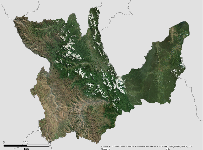
Description
The Region of Huánuco is located in the central part of the country, between the coordinates UTM 245 023.56 E – 553 462.16 E and 8 840 082.91 N – 9 080 734.01 N. It includes areas of the Andes, high forests, low forests, and tropical forests. The Cordillera Blanca occupies part of its northwest territory with the Cordillera de Huayhuash, the Nudo de Pasco to the south, the Cordillera de Raura on the border with Lima, and the Cordillera Azul forming a watershed between the Huallaga and Ucayali rivers.
The Huánuco region has an area of 36,850 km2, with 867,272 inhabitants in 2016 according to INEI. This represents 2.7% of the national population of Peru.
The regions is neighbored by La Libertad, San Martin and Ucayali to the north, east Ucayali region, and to the south by the regions of Pasco and Lima, and to the west by Ancash. The region ranges from 167 to 6334 meters above sea level, with the capitol city situated at 1,894 meters above sea level.
Additional information can be found on the GCF Impact Platform.
Summary
Demographics
Urban vs. Rural Population
| Category | % | |
|---|---|---|
| Rural | 0.61 | |
| Urban | 0.39 |
Ethnic Groups
| Group | % | |
|---|---|---|
| Amuesha (Yanesha) | 980 | |
| Asheninka | 712 | |
| Cashibo-Cacataibo | 499 | |
| Shipibo-Conibo | 403 |
Economy
GDP Breakdown
| Category | % | |
|---|---|---|
| Other sectors | 40.92 | |
| Other service sectors | 19.49 | |
| Agriculture, Livestock, Hunting and Forestry | 16.52 | |
| Commerce | 12.22 | |
| Building | 10.85 |
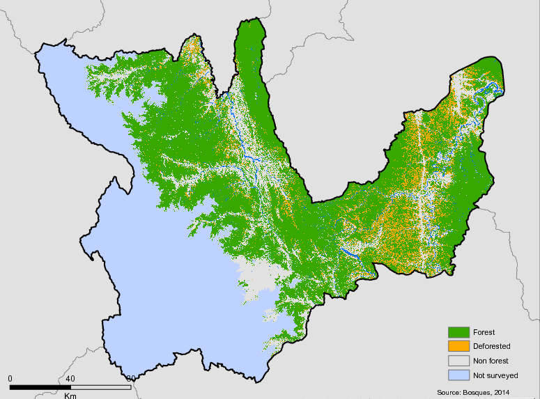
Forest Status
Major Vegetation Types
| Category | km² | |
|---|---|---|
| Others | 37,070 | |
| Non-forested areas | 8,858 | |
| Hill forests | 2,799 | |
| Andean agriculture | 2,055 | |
| Terraced forests | 1,404 | |
| Mountain forests | 1,264 | |
| Flooded forest | 17 |
Forest Management
| Category | km² | |
|---|---|---|
| National Protected Areas | 16 | |
| Timber forest concessions | 12 | |
| Native titled communities | 9 | |
| Private Conservation Areas - ACP | 1 |
Drivers of Deforestation
Causes of deforestation in Huánuco include include agricultural activities, forest fires and diseases, and the uncontrolled felling of trees. A substantial driver in some areas is illegal mining, which is particularly prevalent in the province of Puerto Inca, where it is responsible 16% of the loss in vegetation cover.
At present, the deforestation of tropical forests is a real threat. In Huánuco the rates of deforestation in have been much more intense in dry and semi-arid areas, especially in the mountains. This is likely due to the fact that drier areas and higher altitudes in Huanuco are more suitable for livestock production. The soils of these regions, in general, are richer and easier to cultivate than the old soils of the tropical plains, which are largely depleted of nutrients and have restrictions in place to prevent agricultural expansion.
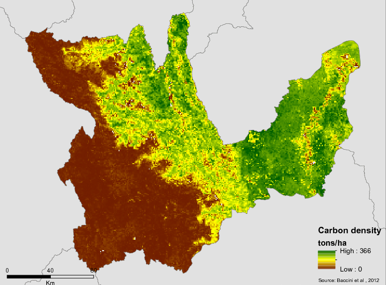
One of these consequences of deforestation in Huánuco is the release of forest carbon into the atmosphere. Deforestation also leads to a loss in water retention, and increases the impact of droughts in the region.
Deforestation Rates
Notes
| a. | Due to different methodological approaches and base years, Forest Status data fields may differ slightly. Data sources for each field are listed below. |
Sources
| 1. | National Institute of Statistics and Informatics. Yearbook of Environmental Statistics 2015 |
| 2. | Data obtained from the National Institute of Statistics and Informatics |
| 3. | (INEI, 2016) link |
| 4. | National Institute of Statistics and Informatics. Values at Constant Prices of 2007 |
| 5. | Jurisdictional profiles of the member regions of the Group of Governors for Climate and Forests in Peru. Alternate Development Mechanisms, Lima: 2018 |
| 6. | (PNUD-Perú, S/F) link |
| 7. | Data obtained from the Integrated Foreign Trade Information System. |
| 8. | Geobosques Platform based on the year 2001. |
| 9. | Geobosques 2016 |
| 10. | (MINAM, 2016) link |
Overview of Forest Monitoring and Measurement Systems
Land use change data used by Huanuco is collected thorugh the national forests monitoring system, Geobosques. FAO assists countries in the identification and collection of activity data for their relevant REDD + activities. For example, data on deforestation, afforestation and reforestation are usually collected through satellite data and the changes can be followed through a satellite earth monitoring system (SSMT).FAO provides support and facilitates national processes to develop capacities to conceptualize, design and implement a national SSVT forforestryandto track your changes.This information is the basis for the entry of data into national greenhouse gas inventories and the reporting of REDD + results.Information about forest areas and their changes from the SSVT can also contribute to national efforts to improve forest management.
Peru has been implementing the Forest Coverage Monitoring Module under a phased approach and has started to monitor the Amazon rainforest, quantifying only the emissions linked to deforestation.
Reference Levels and Targets
Deforestation Rates
Sources
| 1. | Rio Branco Declaration based on national FREL |
| 2. | (MINAM, 2016) link |
Laws, Policies & Strategies
Strategies and Policies
Regional Integrated development Plan 2014-2021 – Constitutes a new instrument for regional development action in the medium and long term by 2021. Outlines a regional strategic objective of promoting conservation and sustainable use of natural resources and biological diversity for the benefit of local populations, through promoting conservation, restoration and protection of ecosystems, including reforestation, and reduction in deforestation. Formally adopted through REGIONAL ORDINANCE N 00061-2016-CRGRH.
Huanuco Regional Climate Change Strategy 2017-2021 – In 2016, the Regional Environmental Commission finalized the Regional Climate Change Strategy and its Implementation Plan. The Strategy has three strategic objectives associated with the following axes: adaptation to climate change, management of GHG emissions, and governance/institutional development. Also, there are 17 activities planned to comply with the strategy. In 2018, the ERCC was approved through Regional Ordinance No. 080-2018-GRHCO.
Regional Agrarian Strategic Plan 2008-2021– Establishes 5 strategic objectives that include the promotion of agrarian activity in associations, the strengthening of agrarian programs, the promotion of diversified cultivation, the promotion of agrarian competitiveness and the sustainable use of Natural Resources.
Laws and Regulations
Regional Ordinance 71/2017 – declares regional interest in the zoning and forest management of the department of Huánuco and establishes the technical team responsible for developing forest zoning.
Regional Ordinance 68/2017 – Approves the creation of the infrastructure of spatial regional data of the regional government of Huánuco
Regional ordinance 67/2017 – approves the modification of the regional ordinance n ° 095-2014-cr-grh, which approves the recognition and recommendation of the regional environmental commission car- Huánuco
Ordinance 61/2016 – formally adopts the regional integrated development Plan -2014-2021
Regional Ordinance 58/2016 – declares as regional priority and interest area the recovery and environmental conservation of El Totoral wetlands
Regional Ordinance No.047-2016-CR-GRH – approves the proposal of the Regional Conservation Area “Bosque Montano de Carpish” and its technical file.
REGIONAL ORDINANCE N ° 031 – 2015 – CR-GRH– Approves the Modification of the Conformation of the Regional Technical Commission of the Ecological and Economic Zoning of the Territorial Organization of the Huánuco Region.
Regional Ordinance No.098-2014-CR-GRH – declares the conservation of biological diversity and the ecosystem values of the Carpish-montane forest as of regional public interest.
Regional Ordinance No.095 2014 CG-GRH-Approves the recognition and re-composition of the Regional Environmental Commission.
Regional Ordinance 47/2013 – Approves modifications to the Rules of Organization and Functions (ROF), including the structure and duties of the Regional Management of Natural Resources and Environmental Management.
Regional Ordinance 013-2012– The creation of a Regional Environmental Authority has been promulgated, but it is not in operation.In February 2018, through RER 105-2018 / GRH, it has formed a specialized technical committee for the creation and implementation of the Regional Environmental Authority
Regional Ordinance 13/2011 – Establishes the Regional Management of Natural Resources and Environmental Management as regional environmental authority as a technical-normative body, dependent on the general regional management.
Regional Ordinance N°016-2010- CR-GRH – approves the Regional Development Plan: Huánuco by 2021.
REGIONAL ORDINANCE N°052-2006-CR-GRH – creates the Regional Environmental Management System of Huánuco.
Institutional Framework
Regional Management of Natural Resources and Environmental Management- The Regional Management of Natural Resources and Environmental Management, is responsible for exercising the specific functions of the sector in the area of protected areas. It led by a Regional Manager, appointed by the Regional President, with direct dependence on the Regional General Management.
It is responsible for the implementation of the policies, rules and instruments of Regional Environmental Management and the conservation of natural resources, with a view to improving the quality of life of people, guaranteeing the existence of healthy, viable and functional ecosystems in the long-term and sustainable development of the country, through the prevention, protection and recovery of the environment and its components, the conservation and sustainable use of natural resources, in a responsible manner and consistent with respect for the fundamental rights of the individual.
Sub-management of Environmental Management- Institution dependent on the Regional Management of Natural Resources and Environment, is led by Deputy Manager commissioned by the Regional President. It is responsible for compliance with policies, rules and management instruments in environmental matter, implementing regional strategies regarding diversity biological diversity and climate change, within the framework of national strategies .Responsible to Formulate, execute, evaluate, direct, control and administer the plans and policies in environmental matters, in accordance with the plans of local governments. Implements the Regional System of Environmental Management, in coordination with the Regional Environmental Commission.
Sub-management of Natural Resources- A body dependent on the Regional Management of Natural Resources and Environmental Management. Led by a Deputy Manager, commissioned by the Regional President. The institution is responsible for compliance with the policies, norms and management instruments regarding conservation, recovery, management of natural resources, genetic and protected areas of the region.
Sub-management of Environmental Management- body dependent on the Regional Management of Natural Resources and Environmental Management, led by a Deputy Manager commissioned by the Regional President.The institution is responsible for compliance with policies, norms and management instruments in environmental matters, implementing regional strategies regarding biodiversity and climate change, within the framework of the respective national strategies.
Regional Directorate on Agriculture- The Regional Office of Agriculture of Huánuco, is the main institution for coordination at the regional level, of the activities of the Ministry of Agriculture.
In the environmental field, it complies with the proposal of management instruments such as plans, strategies, norms, guidelines, programs and projects to improve the environmental management of the sector, the sustainable use of the land resource for agricultural use, and the reduction of vulnerability and its adaptation to climate change in the sector, with the aim of conserving and making sustainable use of the renewable natural resources of its competence.
Directorate of Communities- The Directorate of Communities, is responsible for promoting, managing and managing the process of physical-legal sanitation of the organization and agrarian property of peasant and native communities. It depends hierarchically on the Regional Director.
Zoning & Spatial Planning
On June 9th, 2017, Huanuco established the technical team responsible for developing the regional forest zoning plan. It includes 2 representatives from the following institutions:
- Regional Council of Huánuco.
- Regional Management of Economic Development.
- Regional Management of Natural Resources and Environmental Management.
- Regional Management of Planning, Budget and Territorial Conditioning.
- Regional Management of Social Development.
- Regional Directorate of Agriculture Huánuco.
- Regional Office of Transportation and Communications Huánuco.
- Regional Directorate of Energy, Mines and Hydrocarbons Huánuco.
- Regional Health Office Huánuco.
- Regional Office of Education Huánuco.
- Regional Direction of Production Huánuco.
- Technical Forestry and Wildlife Administration
Engagement & Participation with Indigenous Peoples and Local Communities
The Region of Huanuco has established a Directorate of Communities which is responsible for overseeing the legal process related to agrarian properties of peasant and native communities. The Directorate reports to the Regional Director. Functions of the Directorate of Communities include:
- Propose the regional agrarian policy for the physical and legal resolution of the communities, in coordination with the Office of Agrarian Planning.
- Perform physical and legal resolution actions of the peasant and native communities, in accordance with established guidelines and norms.
- Coordinate, organize, conduct and evaluate the process of recognition, demarcation and titling of peasant and indigenous communities and their subsequent registration.
- Verify, classify, organize, record, control, track and file titles.
- Conduct and organize the technical file of the titling process.
- Maintain updated registers and registers regarding the physical and legal sanitation of peasant and native communities.
- Maintain an updated directory of the titled and registered peasant communities.
- Absolve legal technical inquiries and issue opinions on matters of its competence.
- Prepare the database of peasant and native communities.
- Other duties assigned by the Regional Director and that corresponds to him by express dispositions
The Regional Government has also developed a project idea to support an Environmental Services Program for native communities in the region, providing compensation for reforestation, ecotourism, and agro-pastoral activities.
Partnerships and Ongoing Initiatives
Expansion of the alliance for reforestation projects with medicinal species, native, exotic and ecotourism species in support for rural communities
- Description
-
8 million soles for Afforestation, Reforestation and Ecosystem Restoration in the Pachitea-Puerto Inca Basin, development of 2,500 hectares to support 2,500 beneficiaries in rural and native communities.
The project is in the initial stagesof development and would adopt a produce-protect approach to protect forests.The project presents an opportunity to stop the expansion of deforestationand to source raw materials to localities with forestry potential and give sustainability to forest conservation activities and the protection ofendangered native communities. At the moment it is inserted in the Multiannualprogramming to 2021, of the Regional Government Huánuco.
- Partners
- Regional Government of Huánuco and multiple provinces and districts
- Initiative Type
- Public Private Partnership
- Initiative Status
- In Discussion
Implementing Strategies for transition at regional level towards a low-emission rural development in Indonesia, Peru, Mexico, Colombia and Kenya
- Description
-
Development of policies and monitoring instruments for rural development plan for the Amazon.
This project seeks reduce emissions of greenhouse gases (GHG) emissions associated with deforestation and promote sustainable use of natural resources in the field of six regional governments in the Peruvian Amazon as contribution to mitigation and adaptation to climate change, biodiversity conservation, improved livelihoods of the local population and the development of practices regional, national and international policies and market mechanisms for rural development under emissions.The project will be implemented in two scales. At the interregional scalepolicies and monitoring instruments will be developed for rural development plans for the Amazon under a competitive, inclusive and low emission approach. The second scale is local and focuses on the basin of the Pachitea to develop a platform for low-emission rural development and strengthen capacities of local authorities and indigenous organizations. Work on the Pachitea is led by Instituto del Bien Comun – IBC.
The project is expected achieve as first product the development of an Interregional Plan for promotion of a low emission development involving all participating regions. The project will also develop a platform for performance monitoring territorial performance as well as models of competitive and inclusive governance and incentives to reduce deforestation.
- Partners
- Regional Governments, Forest Trends, IBC
- Initiative Type
- Technical Assistance Partnership
- Initiative Status
- Under Implementation
Improvement of ecotourism promotion in the Cueva de las Pavas spa and in the Velo de la Novia waterfall in Huánuco.
- Description
-
The project is focused on the District of Mariano Damaso Beraun, Province of Leoncio prado, Department of Huánuco. The project benefits more than 3,117 people and seeks to improve access to ecotourism services for visitors to the Cueva de las Pavas spa and in the Casca del Velo de la Novia. For this purpose, work will be done with local communities and they will be trained in the development of ecotourism. In the same way malocas, trails and viewpoints will be conditioned in addition to spreading the tourist values of these places.
- Partners
- District Municipality of Mariano Damaso Beraun, SERFOR
- Funding Amount
- S / 931,221.49
- Initiative Type
- Project financed with a conglomerate of SERFOR-CAF projects and the executing agency’s own resources
- Initiative Status
- In implementation
Improvement of the environmental information service for the mapping of forest deforestation
- Description
-
The Project “Improvement of the environmental information service for the mapping of forest deforestation” is one of the four projects of the Forest Investment Program (FIP) approved for Peru. This Project seeks to strengthen the capacities of the Peruvian Government and key actors, such as indigenous peoples, to monitor deforestation. To this end, it proposes to articulate the georeferenced information systems, generate and distribute monitoring information, develop capacities to generate and distribute the information generated, the design of a community monitoring system as well as training and equipment for native communities. Specific activities for Huánuco will be defined in 2019.
- Partners
- Ministry of the Environment, Ministry of Economy and Finance, Inter-American Development Bank
- Funding Amount
- S / 39,930,000 for the entire Peruvian Amazon. Total for Huánuco not determined.
- Initiative Type
- Public investment project partially financed with resources from the CIF, operated by the IDB and deposited as a donation / loan to the Peruvian Government (60% donation / 40% loan in general for the entire program)
- Initiative Status
- At the start of execution (2018-2022)
Initiative for Deforestation-Free Cacao
- Description
-
Initiative in the Aspuzana Valley, in the Pucayacu District to increase productive capacity and include farmers in “deforestation-free” cacao value chains.
- Partners
- SERNANP, CIMA-Cordillera Azul, Althelia Ecosphere+
- Funding Source
- Althelia Ecosphere+
Joint Declaration of Intent between the Governments of Peru, Norway and Germany (DCI) "Cooperation for the reduction of emissions of greenhouse gases from deforestation and forest degradation (REDD +) and to promote sustainable development in Peru"
- Description
-
The Joint Declaration of Intent (DCI) is a voluntary cooperation agreement signed by the Governments of Peru, Norway and Germany to achieve the reduction of greenhouse gas emissions produced by deforestation and forest degradation in Peru. It was signed in September 2014 with a validity until 2020 and considers actions for the conservation of forests in the Peruvian Amazon.
The JIU is based on a scheme of financial incentives on the progress and / or fulfillment of deliverables or goals divided into three phases: preparatory phase, transformation phase and payment by results phase. The phases of the JIU are directly related to the strategic actions of the National Strategy on Forests and Climate Change (ENBCC) and different planning instruments for development in Peru, such as: a) the Bicentennial Plan: Peru by 2021, b) The National Environmental Action Plan (PLANAA), c) the Agreed Regional Development Plans of the Amazonian regions in Peru, d) the National Strategy on Climate Change, e) National Strategy on Biological Diversity and its Plan of Action, f ) the National Forestry and Wildlife Policy, among other instruments.
The Phase II Implementation Plan defines in more detail what activities will be carried out in the Amazon Region. This document can be hired at: http://www.minam.gob.pe/cambioclimatico/wp-content/uploads/sites/127/2018/06/Plan-de-Implementación-Fase-II-DCI.pdf
- Partners
- Government of Peru, Government of the Kingdom of Norway Government of the Federal Republic of Germany
- Funding Amount
- Investment made so far at the national level USD6.5 M. Potential for cooperation: Up to USD240 million subject to progress in the goals of each phase and payment for results.
- Initiative Type
- Trilateral agreement between governments at the national level.
- Initiative Status
- In execution (Phase I and II)
National Program of Agrarian Innovation (PNIA)
- Description
-
The PNIA is a national incentive program of the Ministry of Agriculture and Irrigation (MINAGRI) that seeks to contribute to the establishment and consolidation of a modern national system of science, technology and innovation for the development of the Peruvian agrarian sector, decentralized, plural, oriented by the demand, in association with the private sector; with the purpose of increasing profitability and improving the competitiveness of the sector, through the generation and adoption of sustainable and environmentally safe technologies. This Program is conducted by MINAGRI and allows the implementation of projects oriented to innovation and technology development, which are financed by competitions. In Ucayali, 6 projects have been financed: 4 for extension services, 1 for applied research and 1 for strategic research. In San Martin, at least 23 projects have been financed: 4 for adaptive research, 1 for competency-based training, 1 for seed companies, 3 for strategic research and 14 for extension. In Huánuco, 8 projects have been financed: 5 on extension services and 3 on seed companies. In Amazonas, 26 projects have been financed: 6 for strategic research, 3 for adaptive research, 11 for extension services, 11 for competency-based training, 2 seed companies, 1 for applied research and 1 for technology transfer. In Piura, 43 projects have been financed: 3 for strategic research, 6 for adaptive research, 30 for extension services, 1 for skills training, 1 for seed companies, and 2 for technology transfer. In Loreto, 6 projects have been financed: 1 for basic research, 3 for applied research and 2 for technology transfer.
- Partners
- Ministry of Agriculture and Irrigation, National Institute of Agrarian Innovation
- Funding Amount
- Not determined for individual jurisdictions
- Initiative Type
- Incentive program for agrarian innovation at the national level
- Initiative Status
- Under implementation
National UN-REDD Peru Program
- Description
-
The UN-REDD National Program seeks to strengthen the strategic framework necessary for the implementation of REDD + and the ENBCC. Thus, it is expected to improve regional governance for the implementation of the ENBCC, NDC and REDD +, provide national or regional public institutions with instruments that facilitate the implementation of ENBCC, REDD + and NDC, develop public and private investment projects for the implementation of the policy, programs and measures prioritized in the framework of the ENBCC, to elaborate a proposal of reference level of forest emissions that integrate emissions data due to forest degradation, in addition to achieving that the indigenous approach is integrated in the module of forest cover and other SNIFFS modules in Peru, as appropriate. Specific activities for Ucayali will be defined in 2019.
- Partners
- Ministry of the Environment, UNDP, UNEP, FAO
- Funding Amount
- USD 4,065,779
- Initiative Type
- Project implemented through the national implementation modality (component under UNDP) and direct implementation (UNEP and FAO components)
- Initiative Status
- At the start of execution. Period December 2017-May 2020
Phase 3 of the Forests, Farms and Finance Initiative
- Description
-
Phase 3 of the Forests, Farms and Finance Initiative “Building bridges between local policies, REDD + and initiatives for sustainable supply chains” will support the construction of jurisdictional low emissions rural development plans.
In Peru, the 3FI initiative is led by the Earth Innovation Institute and the Amazon Regional Council (CIAM, in Spanish) and is developing incentives for low-emission rural development under a production and protection approach. The activities of 3FI in the Peruvian Amazon are led by the regional governments and are open to the participation of any public or private institution that wishes to contribute. 3FI considers with special attention the participation of indigenous peoples and women in the activities to be carried out. The initiative is based on empowering the progress of each region to make the necessary incentives proposals by building tailored instruments for each jurisdiction. Output from the project include: (a) developing regional plans or roadmaps to promote a transition to low-emission rural development; (b) promoting a transparent dialogue process at the regional level which includes the perspectives of indigenous peoples and women; and (c) developing a business plan to attract private investment and promote low-emission rural development in the Peruvian Amazon.
- Partners
- Earth Innovation Institute, CIAM
- Initiative Type
- Technical Assistance Partnership
- Initiative Status
- Under Implementation
Phase II of the Support to the Implementation of the National Strategy for the Reduction of Emissions for Avoided Deforestation and Forest Degradation in Peru "(RPP-2)
- Description
-
The RRP-2 Project 1.1. seeks to create the necessary conditions for the preparation and implementation stage of REDD + in Peru. This Project will consider strengthening spaces for citizen participation, such as the REDD + Indigenous Tables, the design of a grievance mechanism, implementing the PPIA, strengthening regional governments to implement the NDC and the ENBCC, and conducting studies for the effectiveness of strategies and land use planning instruments, contribute to the implementation of the national REDD registry, design benefit sharing mechanisms, improve the forest monitoring platform, update the forest reference level, design early response protocols to the monitoring reports of forests and implement a pilot of the Safeguards Information System. Specific activities for Amazonas will be defined in 2019.
- Partners
- Ministry of the Environment, FCPF, Ministry of Economy and Finance, Inter-American Development Bank
- Funding Amount
- USD 5,000,000.00 for all of Peru. Total for Amazonas not determined.
- Initiative Type
- Project that enters as a donation from the FCPF to the Peruvian Government through the IDB. Executed by MINAM (PNCB Executing Unit)
- Initiative Status
- At the start of execution
Preparing the way for the implementation of the Transformation Phase of the Joint Statement of Intent signed by the Governments of the Republic of Peru, the Kingdom of Norway and the Federal Republic of Germany
- Description
-
This project is considered as the first disbursement by the Norwegian Government to the Peruvian Government associated with the DCI. It considers four components or results: 1) the Government of Peru has planned the implementation of Phase II of the JIU and has begun its execution efficiently, 2) the zoning and forest management in the San Martin and Ucayali regions has increased, 3 ) value of the increased forest in order to be more competitive against the activities that cause deforestation and forest degradation, and 4) control of illegal activities that cause deforestation and forest degradation has increased. Activities in Huánuco included the participation of the Regional Government of Huánuco in the design of the Implementation Plan for Phase II of the DCI, among other activities.
- Partners
- Ministry of the Environment, UNDP
- Funding Amount
- USD 6,135,722. Total executed in Huánuco not specified.
- Initiative Type
- Project executed through UNDP under the modality of national implementation
- Initiative Status
- In execution Period: June 2016-August 2018
Productive Landscapes in the Peruvian Amazon (Ucayali and Huánuco)
- Description
-
The Project seeks to promote the management of sustainable landscapes in the Huánuco and Ucayali regions. It considers eleven results: 1) policies and planning for land use strengthened and aligned including the approach of sustainable landscapes, resilience and inclusion, 2) landscape governance strengthened for the development of public policies, land use and participatory processes of decisions, 3) monitoring and capacity building to enforce the law, 4) increased public finance flow for effective territorial governance, 5) green commodity value chains provide incentives to farmers for sustainable production, 6) activities sustainable economic in the landscapes promoted and articulated to markets, 7) sustainable and inclusive production models scale at the landscape level, 8) farmers and communities prepared to implement sustainable practices, 9) ecological restoration and conservation programs with public and private participation, and 10) effective management of knowledge in support of management or of productive landscapes in the Peruvian Amazon. Specific activities for Huánuco will be defined in 2019.
- Partners
- Ministry of the Environment, UNDP
- Funding Amount
- USD18,346,927. Total for Huánuco not determined.
- Initiative Type
- Project in direct execution UNDP with financing from the GEF
- Initiative Status
- In execution Period 2018-2023
Public-Private Coalition of the Declaration of San Martin
- Description
-
This Coalition of 52 member organizations from government, private sector and civil society seeks to promote sustainable rural development and create synergies between regional governments, the private business sector, producer organizations, NGOs and organizations representing indigenous peoples. The coalition has established an agenda to promote development amazon focused on: i) ensuring land rights and forest native communities and agricultural and forestry producers; ii) optimizing the sustainable use of forest landscapes in the Amazon; iii) building the set of enabling conditions and generate the necessary changes for rural development low emission. Goals of the coalition include reducing deforestation associated with agriculture, creating roadmaps for public – private coordination by Amazon region, designing an architecture of financing, increasing the productivity of agricultural crops and increasing the value of forests and promote forest plantations. It is expected that these measures will open a pathway to build sustainable jurisdictions, especially in the value chains of the Amazon through a Production – Protection approach. A group of companies from the Pro Ucayali network, comprising the largest companies in the region, have joined the coalition.
- Partners
- GORE San Martin, GORE Ucayali, GORE Amazonas, GORE Madre de Dios, GORE Huanuco.
- Initiative Type
- Public Private Partnership
- Initiative Status
- Agreement Signed
Recovery of the degraded ecosystem of the Bolaina hamlet in Huánuco
- Description
-
The project is focused on the district of Luyando, Province of Leoncio Prado, Department of Huánuco. The project benefits 266 people and seeks to recover 70 hectares of bolaina forests. It is expected to contribute to reforest degraded areas in conservation concessions, implement a control and surveillance system to reduce deforestation and improve local capacity for conservation.
- Partners
- District Municipality of Luyando
- Funding Amount
- S / 298,237.00
- Initiative Type
- Project financed with a conglomerate of SERFOR-CAF projects and the executing agency’s own resources
- Initiative Status
- In implementation
Recovery of the upper part of the Aucayacu River in the town of Alto Yacusi in the department of Huánuco
- Description
-
The project focuses on the district of José Crespo y Castillo, Province of Leoncio Prado, Department of Huánuco. The project reaches 180 inhabitants and covers 60 hectares in the middle part of Rio Aucayacu. It seeks to improve the protection of the microbasin with three varieties of bamboo, reforest degraded areas in vulnerable areas, promote the development of agroforestry systems and help environmental awareness and education
- Partners
- District Municipality of José Crespo y Castrillo, SERFOR
- Funding Amount
- S / 1,199,999.98
- Initiative Type
- Project financed with a conglomerate of SERFOR-CAF projects and the executing agency’s own resources
- Initiative Status
- In implementation
Recovery, conservation and use of aquatic turtles in communities of Tournavista in Puerto Inca, Huánuco.
- Description
-
The Project is focused on the district of Tournavista, Province of Puerto Inca, Department of Huánuco. The project benefits more than 1002 inhabitants and seeks to ensure the use and marketing of taricayas by the Las Palmas, Macuya, Naranjal and Nueva Alianza de Baños communities. It is expected that at the end of the project the local population will carry out an adequate management of this species, improve their knowledge about the conservation of the Taricaya and strengthen their organizations for the commercialization of this species.
- Partners
- District Municipality of Tournavista, SERFOR
- Funding Amount
- S / 1,185,911.89
- Initiative Type
- Project financed with a conglomerate of SERFOR-CAF projects and the executing agency’s own resources
- Initiative Status
- In implementation
REDD+ Cordillera Azul National Park
- Description
-
Through an innovative Public-Private Partnership between the Peruvian State through the National Service of Protected Areas-SERNANP, the Centro de Investigación y Manejo de Áreas Naturales–CIMA Cordillera Azul, and the Althelia Climate Fund, the Cordillera Azul National Park REDD+ Project is preserving more than 1.3 million hectares of pristine montane rainforest within the Cordillera Azul National Park, and supporting the sustainable land use of its rich buffer zone large of 2.5 million hectares. The Park, which is among one of the largest protected areas in Peru, is bigger than the US state of Connecticut and is home to around 6,000 plant species, more than 80 large and medium size mammal, around 180 species of fishes, and over 600 species of birds. On large mammals, 11 are listed on CITES-I, including spectacled bears, giant otters, jaguars, cougar, bush dogs and giant armadillos; as well as 9 bird species, including harpy eagle, curassow and several macaws.
The project will protect this unique biodiversity and restore degraded lands with agroforestry systems (cocoa & coffee) in the buffer zone relied upon by small farmers and local communities for their livelihoods, and as consequence it will avoid more than 15 million tonnes CO2 emissions over the next 6 years due to the reduction on deforestation, which is equivalent to the emissions from all the flights passing through London’s Heathrow Airport over the same period.
- Partners
- Peruvian State through the National Service of Protected Areas-SERNANP, the Centro de Investigación y Manejo de Áreas Naturales–CIMA Cordillera Azul, and the Althelia Climate Fund
Saweto Dedicated Grant Mechanism – Peru
- Description
-
Support Indigenous Peoples in the Peruvian Amazon in their efforts to establish the enabling conditions for sustainable forest management practices. Project Components:
Component 1 – Native Land Titling
Component 2 – Indigenous Forestry Management
Component 3 – Project Management, Monitoring and Evaluation
- Partners
- AIDESEP, CONAP, WWF
- Funding Amount
- US$5.5 million
- Initiative Type
- Iniciativa de Pueblas Indigenas
- Initiative Status
- Under implementation
Support for the implementation of the Joint Declaration of Intent on REDD + between Peru, Norway and Germany (WWF-DCI)
- Description
-
The WWF-DCI Project was executed during the 2015-2016 period and sought to contribute to the early implementation of the DCI. The Project considered five components or expected results: a) result 1. the Government of Peru, civil society and indigenous peoples increase their commitment to the implementation of Phase 2 of the JIU, 2) result 2. agrarian policies and instruments of regional development are improved and incorporate the approach of low carbon agriculture and production, protection and inclusion in San Martin and Ucayali, 3) result 3. Deforestation in two regions of the Peruvian Amazon (San Martin and Ucayali is monitored, 4) result 4. land tenure of improved native communities, and 5) result 5. improvement of forest protection in territorial reserves. Activities for the Amazon Region included the participation of the Regional Government of Amazonas in the design of the Implementation Plan for Phase II of the JIU.
- Partners
- Ministry of the Environment, Regional Government of Loreto, WWF, AIDESEP, CONAP, Forest Trends, Earth Innovation Institute, Alternate Development Mechanisms
- Funding Amount
- NOK 47,500,000. Total executed in Amazonas not specified.
- Initiative Type
- Project executed through WWF under the leadership of MINAM, MINCU, GORELO, WWF, Forest Trends, Earth Innovation Institute, Alternate Development Mechanisms
- Initiative Status
- Completed Period: 2015-2016
Sustainable Forestry Development Program, inclusive and competitive – SERFOR – CAF
- Description
-
This project supports regions in strengthening their management capacity and monitoring in forestry, with their equipment offices and checkpoints. The project also has specific activities with regional governments and the management of protected areas, forest land, advancing the national forest inventory, implementation of spatial data infrastructures, implementation of anticorruption plan in the forestry sector, improved control and forest monitoring and promotion of forestry value chains. The project also has a grant fund for submitting public investment projects at regional level.
- Partners
- National forest and Wildlife Service, Andean Development Corporation, regional governments
- Funding Source
- National forest and Wildlife Service, Andean Development Corporation, regional governments
- Funding Amount
- $76M
- Initiative Type
- Technical Assistance Partnership, Public Investment
- Initiative Status
- Under Implementation
Sustainable Productive Landscapes
- Description
-
From an integral management of the landscape, the objective of the project is to promote sustainable production systems, free of deforestation, to generate multiple environmental benefits. The project covers a national scale at the level of policies and regulations, and another at the level of territorial management. The latter is located in the Ucayali region (Padre Abad province and Nueva Requena district) and in the Huánuco region (Puerto Inca province). The project area covers 2.2 million hectares, in which there are protected natural areas, forests of permanent production, timber and non-timber concessions, rural properties, native communities and approximately one third of the territory is not categorized.
The project is based on three components:
1. Improve the policy, planning and governance framework for the harmonized use of land and avoid deforestation.
2. Promote incentives and financial mechanisms for sustainable production, providing access to producers to certification standards and markets.
3. Strengthen technical capacities to rehabilitate and preserve ecosystems.
- Partners
- UNDP, Ministry of the Environment
- Funding Source
- UNDP
- Funding Amount
- $ 500,000
- Initiative Status
- In Implementation