Piura, Peru
Peru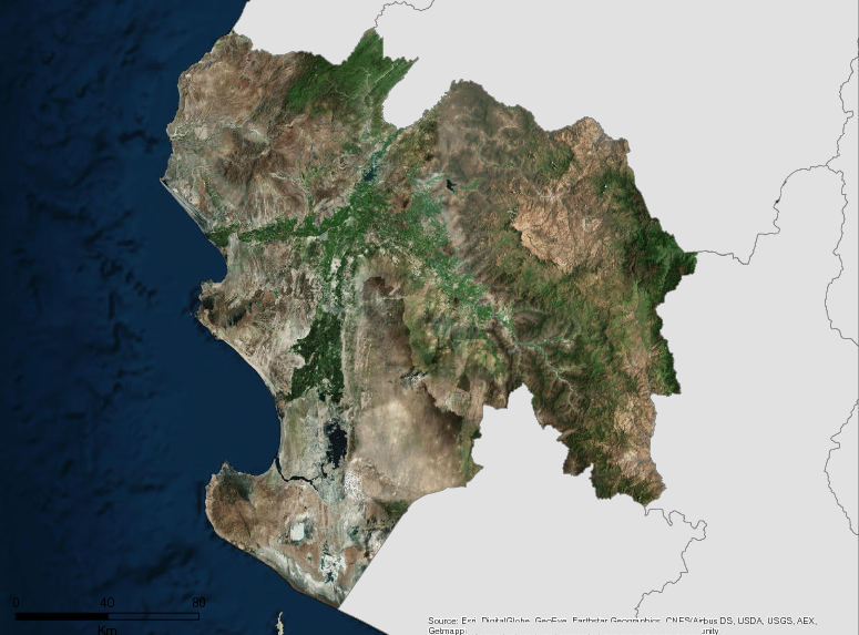
Description
The Piura Region is located in the North-Western zone of Peru, between latitude South 4º04’50 “and 6º22’10” and longitude West 79º13’15 “and 81º19’35”; at a distance of 981 km from the city of Lima. Its territorial extension is 35,892km2, which represents 2.79% of the country’s territory.
At a political-administrative level, the region is divided into 08 provinces: Piura, Sullana, Talara, Paita, Sechura, Morropón, Huancabamba and Ayabaca. Within these 8 provinces lie 65 districts.
The climate of the department of Piura is varied. The coast is warm with high temperatures throughout the year, which fluctuate between 34.2ºC and 15ºC. In the mountains, the climate is mild with seasonal rainfalls. The region is particularly prone to effects from El Niño Southern Oscillation, which may be exacerbated by climate change.
Piura is a region with a unique biodiversity, which is an important source of resources on which activities such as agriculture, fishing, aquaculture and tourism depend. It is important to note that according to the Ecological and Economic Zoning of the Region (2013), 22.30% of the continental territory of Piura has aptitude for conservation and protection, which reflects the ecological value of several important areas in the region.
Additional information can be found on the GCF Impact Platform.
Summary
Demographics
Urban vs. Rural Population
| Category | % | |
|---|---|---|
| Urban | 77.00 | |
| Rural | 23.00 |
Economy
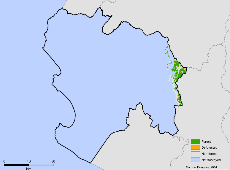
Forest Status
Major Vegetation Types
| Category | km² | |
|---|---|---|
| Dry forest | 17,919 | |
| Others | 8,333 | |
| Dry scrub | 4,612 | |
| Natural grass | 2,934 | |
| Intensive agriculture | 2,287 |
Forest Management
| Category | km² | |
|---|---|---|
| Peasant communities | 18,291 | |
| Private lands | 9,310 | |
| Without defined tenure or other types of tenure without available data | 5,754 | |
| National Protected Areas | 1,248 | |
| Private Conservation Areas - ACP | 563 | |
| Regional Conservation Areas | 288 | |
| Areas of Environmental Conservation - ACA | 205 | |
| Concessions for conservation | 130 | |
| Non-timber forest concessions | 56 | |
| Ramsar site | 34 | |
| Concessions for Forestation and Reforestation | 14 |
Drivers of Deforestation
Currently in Piura there is no specialized and specific document to determine the drivers of deforestation; however, in the Technical Report for determining the rate of deforestation in Piura, requests for change of use and requests for oil and other deforestation are mentioned as part of the analysis of the determination. In addition, there is also the document “Study of the costs of desertification and land degradation in the department of Piura (Morales, et al., 2013) and the” Study of identification, prioritization, evaluation and integration of economic valuation of ecosystem services in the planning and public investment processes of the Piura Region “(Orihuela and Albán, 2012)
Deforestation Rates
Notes
| a. | Due to different methodological approaches and base years, Forest Status data fields may differ slightly. Data sources for each field are listed below. |
Sources
| 1. | (INEI, 2016) link |
| 2. | Instituto Nacional de Estadística e Informática. Población estimada para el año 2017 |
| 3. | Instituto Nacional de Estadística e Informática. |
| 4. | Información Calculada con Datos del Instituto Nacional de Estadística |
| 5. | Información tomada de la Memoria Final de la Zonificación Económica Ecológica |
| 6. | (PROMPERÚ, S/F) link |
| 7. | Geobosques 2001 |
| 8. | Geobosques 2016 |
| 9. | (MINAM, 2016) link |
| 10. | Other: Dry Forests |
| 11. | (MINAM, 2016) link |
Overview of Forest Monitoring and Measurement Systems
Currently, MINAM provides information on tropical forests; however, this information does not cover the coverage of dry forests in the Piura region.
Reference Levels and Targets
Deforestation Rates
Sources
| 1. | (MINAM, 2016) link |
Laws, Policies & Strategies
Strategies and Policies
Regional Forest Plan (PRDF 2013-2032) – establishes a vision and the strategies for the restoration of forest resources and environmental services.
Master Plan of the Dry Forest Regional Conservation Area Salitral – Huarmaca, 2017-2021– A planning document for the the first protected natural area of Regional Administration in the department of Piura – The Regional Conservation Area Bosques Secos Salitral – Huarmaca. The plan seeks to develop and promote practices for the sustainable use of dry forest resources that ensure the sustainability of the ecosystem and the valuable objects of conservation that houses.
Regional Environmental Action Plan Piura 2016 – 2021 – Intended to be a long-term regional planning instrument, formulated on the basis of the Regional Environmental Policy and Regional System of Environmental Management. The plan contains the priority environmental goals for a six year period for the region and has an objective to improve the quality of life of people, ensuring the existence of healthy, viable and functional ecosystems in the long term, the sustainable development of Piura, through prevention , protection and recovery of the environment and its components, the conservation and sustainable use of natural resources, in a responsible and consistent manner
Regional Development Plan 2016-2021 – This development plan includes a goal “to promote and execute actions of territorial management (ordering, demarcation and cadastre) at the regional and local level”, with an indicator of success that includes “percentage of progress in the meso and micro processes of the ecological economic zoning of the department of Piura “.
Regional Action Plan to Combat Desertification and Drought– Approved through Regional Ordinance 286 – 2014, the plan seeks to provide political guidelines for the effective management of the fight against desertification and mitigation of the effects of drought in the arid, semi-arid and dry sub-humid areas of Piura.
Regional Strategy for Biological Diversity– approved through the Ordinance Regional Ordinance 279-2013-GRP / CR. This strategy has five objectives: To conserve, recover and reduce threats to biodiversity and priority ecosystem services for the region; sustainable use and equitable distribution of the benefits derived from biodiversity; generate awareness of the value of biodiversity in all population groups; integrate and increase scientific knowledge about the region’s biodiversity; and strengthen and articulate institutional capacities for the conservation and sustainable use of biodiversity.
Laws and Regulations
Ordinance 392/2017 – Approves the Master Plan of the Dry Forest Regional Conservation Area Salitral -Huarmaca, for the period 2017-2021, as a higher-level planning document to develop and promote practices for the sustainable use of dry forest resources that ensure the sustainability of the ecosystem.
Ordinance 378/2017 – Approves the regional environmental agenda 2017 – 2019 – the Regional Environmental Agenda 2017-2019, prepared by the Regional Environmental Commission, is a management instrument of a cross-sectoral nature of mandatory compliance for the treatment of environmental issues in the region in the short term, conservation of natural resources and improvement of quality of life, in order to achieve sustainable regional development in four (04) fronts: a) Front of Biodiversity, b) Environmental Quality Front, c) Environmental Governance Front, and d) Climate Change Front.
Ordinance 346/2016 – Approves the Regional Environmental Action Plan of Piura within the framework of the Regional Environmental Policy.
Ordinance 316/2015– Approves the Policy Guidelines for the Territorial Planning of the Piura Region. Entrusts the Regional General Management, in coordination with the Regional Management of Natural Resources and Environmental Management and the Regional Center for Strategic Planning – CEPLAR, with the implementation of this territorial planning.
Ordinance 286/2014– Ordinance that approves the regional action plan to combat desertification and drought
Ordinance 261/2013– Ordinance that approves the economic ecological mesozonification of the piura department
Ordinance 274/2013 – Ordinance that modifies the regulations of organization and functions – ROF of the piura regional government, including the function of issuing environmental certifications
Ordinance Regiona 249-2012-GRP – Creates the Regional Program for the Conservation and Sustainable Use of the Forest Heritage -Norbosques based on a previous program focused on dry forest
Regional Ordinance No. 224-2011 / GRP – Approves the Regional Strategy on Climate Change and raises five objectives: identification of vulnerabilities and adaptation measures, improvement of decision-making processes at the policy level, promotion of clean energies and processes, as well as energy efficiency, integrated water management in the Chira-Piura basin, research and oriented towards the implementation of information and knowledge measures on climate change.
Regional Ordinance 147-2008 – Establishes the Regional System of Conservation of Natural Areas of Piura-SRCAN is created in charge of the management and monitoring of regional conservation areas, private conservation areas, and other conservation categories.
Regional Decree No. 006-2006 – Approves the Regional Policy on Environmental Education. There are 4 strategic objectives that imply the achievement of environmental awareness in population and institutions improving knowledge, skills and practice
Institutional Framework
Regional Management of Natural Resources and Environment Management – Formulates, proposes, directs, executes, and administers the regional policies related to protected areas and environment in accordance with regional and sectoral plans.
Regional Management of Economic Development – Formulates, proposes, directs, executes, and administers the regional policies related to agriculture, mining, fishing, energy, and tourism in accordance with regional and national plans.
Regional Committee against Illegal Logging, Timber Trafficking and Transport- group to coordinate to reduce illegal logging consisting of 7 public institutions and led by the Piura government. The group has developed an interactive map of illegal logging in Piura and is developing mechanisms for sustainable development of forest resources in farming communities through the formation of local Forest Management Committees.
Zoning & Spatial Planning
Piura has developed an Ecologic and Economic Zoning at the meso level (scale 1/100,000), which has been approved through Regional Ordinance No. 261-2013-GRP-CR .
Currently, ZEE is being applied as a guiding instrument for decision making and sustainable management of the territory, taking advantage of the potential and minimizing the risks for the benefit of the population. In this sense, they are articulating the EEZ to other territorial management instruments such as the Concerted Development Plan.
Additionally, in this department four (04) micro-EEZ processes (1/25 000 scale) have been executed in priority areas of the provinces of Ayabaca, Huamcabamba, Morropón and Sullana, with resources from the Budget Support Agreement Euro Eco Trade
Engagement & Participation with Indigenous Peoples and Local Communities
In accordance with the Law of Campesinos No. 27908 and its regulations approved with Supreme Decree N ° 025-2003-JUS, and after meetings held by the Assembly of Campesinos in Piura, the Government of Piura approves 30 of March 2011 Regional Ordinance No. 205-2011 / GRP-CR declaring the “Rondas Campesinas” as “Protectors of the Páramo Ecosystem”. The Regional Government also approved Regional Executive Resolution No. 082-2006 / GRP-PR, which established the approval of the “forest and wildlife registry on lands privately owned by the state and peasant communities” within the jurisdictional scope of the Piura Regional Government. This was later used as precedent to approve the creation of the Regional Program for the Sustainable Management of Dry Forests – Norbosque Piura through Regional Ordinance No. 130 – 2007 / GRP-C R.
In conjunction with CIPCA, the Regional Government of Piura promotes a “space for dialogue and coordination, with the communities and peasant patrols for the implementation of a regional policy to promote the rights and well-being of the communities and peasant patrols.”
Partnerships and Ongoing Initiatives
Binational Integrated Management of transboundary river basins as mitigation and adaptation to climate change water without frontiers
- Description
-
The initiative will improve binational watershed management of the border area with Ecuador- Peru. The project seeks to advance both climate change adapatation and mitigation measures and will help reduce povertyfrom 2016-2018.. Currently the project is undergoing a participatory process to establish forest roundtable. The project is supported by partner organizations likeEIA, ECO, REDD, Ecological Forum and DAR.
- Partners
- AIDESEP
- Initiative Type
- Technical Assistance Partnership
- Initiative Status
- In Progress
Capacity Building Management System Regional Natural Areas Conservation
- Description
-
The initiative will create 15 Private Conservation Areas. Currently, Piura has 233,382.10 hectares of conservation areas, which represents 6.5% of the regional territory as part of the Regional Conservation System.
- Partners
- Servicio Nacional de Áreas Naturales Protegidas – SERNANP
- Initiative Type
- Public Investment
- Initiative Status
- In Pogress
Development of capacities for forest conservation and REDD + mechanisms in the Republic of Peru
- Description
-
This project considers technical assistance to implement key components of the National Strategy on Forests and Climate Change. Among the programmed activities are considered: a) develop and implement a multisector management system, effectively implement and strengthen actions against deforestation, b) complete the diagnosis and baseline vulnerability of forest ecosystems including wetlands through the introduction of technologies advanced remote sensing, c) contribute to the construction of the national forest and wildlife plan, d) facilitate the process of participation of public and private actors, e) support the implementation of SNCVFFS, f) implement training in new platforms for detection of alerts provided by JICA-JAXA cooperation and others, g) strengthening capacity for the classification of forest / non-forest cover in dry forests, and h) transfer of technical capacities at the national and sub-national levels. Specific activities for Piura will be defined in 2019.
- Partners
- Ministry of the Environment, Ministry of Agriculture and Irrigation, SERFOR
- Funding Amount
- Undefined
- Initiative Type
- Project of technical cooperation through JICA to national agencies (MINAM-PNCB, SERFOR-MINAGRI)
- Initiative Status
- In implementation
Interregional Northern Forests Platform
- Description
-
The objectives of the Platform are: to share a common territorial vision that integrates the fight against deforestation and forest degradation with the generation of local productive and economic development options. In addition, platform wants increase visibility to contribution of forests in environmental, economic and social terms and reduces vulnerability to natural hazards; develop climate change mitigation strategies through a macroregional conservation system that integrates dry forests, cloud forests, mangroves and coastal marine areas. Also, design a common strategy against illegal logging from forest mapping and identification of deforested areas; strengthen internal coordination between natural resource management and environmental management, economic development and planning offices; enhance management capacity to secure funding for conservation projects; develop broad strategies for partnerships and synergies with institutions and the recognition of the macroregional platform by MINAM and SERFOR as the valid interlocutor of regional governments.
- Partners
- GORE Piura, GORE Tumbes, GORE Lambayeque
- Initiative Type
- Governmental Planning Initiative
- Initiative Status
- In Design
National Program of Agrarian Innovation (PNIA)
- Description
-
The PNIA is a national incentive program of the Ministry of Agriculture and Irrigation (MINAGRI) that seeks to contribute to the establishment and consolidation of a modern national system of science, technology and innovation for the development of the Peruvian agrarian sector, decentralized, plural, oriented by the demand, in association with the private sector; with the purpose of increasing profitability and improving the competitiveness of the sector, through the generation and adoption of sustainable and environmentally safe technologies. This Program is conducted by MINAGRI and allows the implementation of projects oriented to innovation and technology development, which are financed by competitions. In Ucayali, 6 projects have been financed: 4 for extension services, 1 for applied research and 1 for strategic research. In San Martin, at least 23 projects have been financed: 4 for adaptive research, 1 for competency-based training, 1 for seed companies, 3 for strategic research and 14 for extension. In Huánuco, 8 projects have been financed: 5 on extension services and 3 on seed companies. In Amazonas, 26 projects have been financed: 6 for strategic research, 3 for adaptive research, 11 for extension services, 11 for competency-based training, 2 seed companies, 1 for applied research and 1 for technology transfer. In Piura, 43 projects have been financed: 3 for strategic research, 6 for adaptive research, 30 for extension services, 1 for skills training, 1 for seed companies, and 2 for technology transfer. In Loreto, 6 projects have been financed: 1 for basic research, 3 for applied research and 2 for technology transfer.
- Partners
- Ministry of Agriculture and Irrigation, National Institute of Agrarian Innovation
- Funding Amount
- Not determined for individual jurisdictions
- Initiative Type
- Incentive program for agrarian innovation at the national level
- Initiative Status
- Under implementation
National UN-REDD Peru Program
- Description
-
The UN-REDD National Program seeks to strengthen the strategic framework necessary for the implementation of REDD + and the ENBCC. Thus, it is expected to improve regional governance for the implementation of the ENBCC, NDC and REDD +, provide national or regional public institutions with instruments that facilitate the implementation of ENBCC, REDD + and NDC, develop public and private investment projects for the implementation of the policy, programs and measures prioritized in the framework of the ENBCC, to elaborate a proposal of reference level of forest emissions that integrate emissions data due to forest degradation, in addition to achieving that the indigenous approach is integrated in the module of forest cover and other SNIFFS modules in Peru, as appropriate. Specific activities for Ucayali will be defined in 2019.
- Partners
- Ministry of the Environment, UNDP, UNEP, FAO
- Funding Amount
- USD 4,065,779
- Initiative Type
- Project implemented through the national implementation modality (component under UNDP) and direct implementation (UNEP and FAO components)
- Initiative Status
- At the start of execution. Period December 2017-May 2020
Phase II of the Support to the Implementation of the National Strategy for the Reduction of Emissions for Avoided Deforestation and Forest Degradation in Peru "(RPP-2)
- Description
-
The RRP-2 Project 1.1. seeks to create the necessary conditions for the preparation and implementation stage of REDD + in Peru. This Project will consider strengthening spaces for citizen participation, such as the REDD + Indigenous Tables, the design of a grievance mechanism, implementing the PPIA, strengthening regional governments to implement the NDC and the ENBCC, and conducting studies for the effectiveness of strategies and land use planning instruments, contribute to the implementation of the national REDD registry, design benefit sharing mechanisms, improve the forest monitoring platform, update the forest reference level, design early response protocols to the monitoring reports of forests and implement a pilot of the Safeguards Information System. Specific activities for Amazonas will be defined in 2019.
- Partners
- Ministry of the Environment, FCPF, Ministry of Economy and Finance, Inter-American Development Bank
- Funding Amount
- USD 5,000,000.00 for all of Peru. Total for Amazonas not determined.
- Initiative Type
- Project that enters as a donation from the FCPF to the Peruvian Government through the IDB. Executed by MINAM (PNCB Executing Unit)
- Initiative Status
- At the start of execution
Regional Ris3 Innovation Agenda Project Piura
- Description
-
The Project seeks to achieve an impact on regional economic development, based on research and innovation strategies for smart specialization (Research and Innovation Strategy form Smart Specialization, RIS3), which promote a favorable scenario for social and economic growth, with a planning of how to invest in research, development and innovation (R + D + i). This initiative is promoted by the Regional Government of Piura, the National University of Piura, the University of Piura and the Chamber of Commerce and Production of Piura. Account with the subsidy of the Concytec, through Cienciactiva. It seeks to articulate the dynamic proposed by the Regional Development Agency for Piura as a coordination mechanism and inter-sectorial and intergovernmental coordination and that, through the Secretariat of Decentralization, are promoted and directed to lead the articulation of the national Government.
- Partners
- Regional Government of Piura, National University of Piura Chamber of Commerce and Production of Piura
- Funding Amount
- Undetermined
- Initiative Type
- Project implemented with CONCYTEC resources through Active Science.
- Initiative Status
- In implementation
Regional Water Fund (FORASAN)
- Description
-
With the approval of the Regional Ordinance, the Piura Regional Government officially constitutes FORASAN, encouraging the participation of all water users to contribute to the integrated management of water resources in the Chira Piura basin, based on the implementation of the Plan of Water Resources Management and as an operational unit to the Technical Secretariat of the Water Resources Council of the Chira Piura Basin.
The purpose of FORASAN is to capture, manage and channel investments to guarantee the quantity and quality of water resources in the Chira Piura basin. It has strategic allies at the local, regional, national and international cooperation levels such as: user boards, private companies, the Piura Regional Government, the National Water Authority through the Chira Piura CRHC and the National Fund for Protected Natural Areas by the State-PROFONANPE; Also, the National Superintendence of Sanitation Services -SUNASS, The Nature Conservancy (TNC), World Bank, USAID Project FOR Water, Swiss Cooperation – SECO and Fund of the Americas-FONDAM.
- Partners
- The FORASAN is led by the Regional Government of Piura and the National Water Authority – ANA through the Council of Water Resources of the Chira Piura Basin and has an independent mechanism for the management of resources that favors transparency
- Funding Source
- USAID, Swiss State Secretariat for Economic Affairs (SECO)
- Initiative Status
- Developed in 2015.
Services improving protection and sustainable management of forests Regional Conservation Area Dry Salitral Huarmaca
- Description
-
The project seeks to promote sustainable management of ACR Salitral Huarmaca Dry Forest through six primary activities: i) the construction of infrastructure and equipment for management, control and monitoring; ii) the preparation of planning and normative documents of the ACR and provide technical assistance for the design and development of planning software; iii) the development of an efficient system of control, monitoring and surveillance; iv) designing a management plan for the protection of flora and fauna; v) the development of appropriate knowledge and commitments of the population for participation in conservation; vi) a commitment from the local government to suppor the conservation and protection of the ACR.
- Partners
- SERNANP
- Initiative Type
- Technical Assistance Partnership
- Initiative Status
- In Progress
Social Fund of the Integral Bayóvar Project (FOSPIBAY)
- Description
-
The FOSPIBAY is a non-profit civil association that was set up with the purpose of managing the resources of the Social Fund of the Integral Bayóvar Project in social programs aimed at executing projects to benefit the area of influence of the Bayóvar Project. The area of influence of the Bayóvar project is understood to be the Province of Sechura and in particular the San Martín de Sechura Rural Community, included within the territory of the province, located in the department of Piura where the sustainable development projects will be developed. The FOSPIBAY has as priorities: a) health care programs for the elderly, girls, boys and women in gestation, especially those living in poverty and extreme poverty, in agreement with the MINSA or private entities, b) public service centers or similar for rural population centers, providing them with sustainable basic public services, c) scholarships to pay for the education of children and young people, especially those living in poverty and extreme poverty, in the zones rural, d) infrastructure and basic services (education, health, water and sanitation, electrification, access roads), training and strengthening of technical and management capacities, e) improvement of the quality of education in schools, including programs of education promoted by the State, such as equipping schools with the necessary infrastructure to implement the extension of the hours of dictation and the program bilingual English-Spanish teaching, f) construction of basic agricultural infrastructure, g) formation of commercial conglomerates, development of productive chains and technical assistance to agricultural producers, h) promotion of business training and market information for small local entrepreneurs, ei) technology management projects for the recovery, conservation and management of natural resources for production.
- Partners
- FOSPIBAY, Piura Regional Government
- Funding Amount
- Variable depending on annual transfers
- Initiative Type
- Social fund administrator by a civil association
- Initiative Status
- In action
Strengthening capacities for sustainable forest management of the dry tropical forest of the north coast of Peru
- Description
-
This Project funded by the ITTO considers three products: a) improving the management level of the regional administration for the management of the degraded forests of Tumbes, Piura and Lambayeque, b) the public sector and civil society are actively involved in decision-making for sustainable forest management at the regional level, and c) capacities developed for the operational technical management of SFM of community forests on the north coast. Specific activities for Piura not defined.
- Partners
- SERFOR, AIDER, Regional Government of Piura
- Funding Amount
- USD437,478.00 (of which the project costs are USD355,741.00). Specific budget for Piura not defined.
- Initiative Type
- Project of international cooperation with resources of the International Tropical Timber Organization implemented by AIDER
- Initiative Status
- In implementation since the second quarter of 2017